Home / Recent Earthquakes

| Prel. Rep. | Date | Time(UTC) | Time(Local) | Lat. | Lon. | Depth | Mag. | Region | Waveform |
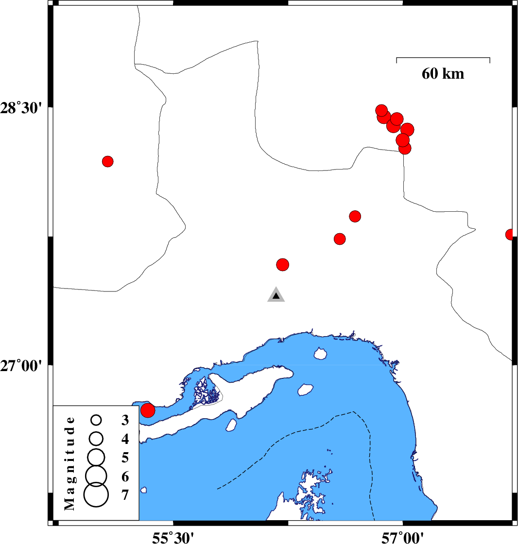
| 2023/02/20 | 07:39:19.6 | 11:09:19.6 | 27.586 | 56.214 | 10 | ML:3.7 | Hormozgan Province, 45 km North of Bandar-e abbas | ||
| 2023/02/19 | 22:02:18.0 | 01:32:18.0 | 27.735 | 56.588 | 12 | ML:3.4 | Hormozgan Province, 68 km North-East of Bandar-e abbas | ||
| 2023/02/15 | 07:50:50.5 | 11:20:50.5 | 28.431 | 56.96 | 12 | ML:3.8 | Kerman Province, 81 km South-West of Jiroft | ||
| 2023/02/11 | 09:54:20.8 | 13:24:20.8 | 28.185 | 55.071 | 14 | ML:3.2 | Fars Province, 83 km South-West of Hajiabad | ||
| 2023/02/11 | 03:12:45.0 | 06:42:45.0 | 28.391 | 56.938 | 12 | ML:4.1 | Kerman Province, 84 km South-West of Jiroft | ||
| 2023/02/10 | 08:43:26.4 | 12:13:26.4 | 28.309 | 56.998 | 10 | ML:3.9 | Kerman Province, 79 km North-West of Kahnuj | ||
| 2023/02/09 | 13:07:51.5 | 16:37:51.5 | 27.866 | 56.688 | 7 | ML:3.4 | Hormozgan Province, 73 km North-West of Dehbarez | ||
| 2023/02/09 | 12:29:54.8 | 15:59:54.8 | 28.369 | 57.029 | 12 | ML:3.9 | Kerman Province, 77 km South-West of Jiroft | ||
| 2023/02/09 | 12:09:52.1 | 15:39:52.1 | 28.48 | 56.861 | 12 | ML:3.5 | Kerman Province, 87 km South-East of Baft | ||
| 2023/02/09 | 09:19:23.9 | 12:49:23.9 | 28.262 | 57.013 | 12 | ML:3.6 | Kerman Province, 75 km North-West of Kahnuj | ||
| 2023/02/08 | 23:25:21.9 | 02:55:21.9 | 28.444 | 56.876 | 12 | ML:4.1 | Kerman Province, 92 km South-East of Baft | ||
| 2023/02/07 | 02:30:57.5 | 06:00:57.5 | 26.734 | 55.333 | 12 | ML:4.2 | Persian Gulf, 53 km North-East of Bandar-e lengeh | ||
| 2023/01/25 | 17:19:00.8 | 20:49:00.8 | 27.761 | 57.706 | 12 | ML:3.3 | Kerman Province, 21 km South of Kahnuj |