
The Zagros fold-thrust belt, which extends for approximately 1600 kilometers from the Taurus mountains in northeastern Turkey, the Kurdistan region in northern Iraq, and southwestern Iran, continues to the Strait of Hormoz, with a northwest-southeast orientation.
The northeastern boundary of the Zagros belt is marked by the Main Zagros fault, which separates the Senjed-Sirjan zone from the Zagros mountains (Stocklin, 1974; Berberian, 1995). However, some researchers (Alavi, 1994) consider the thrust zone located to the northeast of the main Zagros fault, which is associated with metamorphic rock outcrops (Senjed-Sirjan zone), as part of the Zagros belt (Figure 1). Since the northwestern continuation of the main Zagros fault (north of 33° latitude) exhibits right-lateral strike-slip faulting and is seismically active, it is referred to as the young main Zagros fault (Tchalenko and Brand, 1974).
The structure of the crust beneath the Zagros can be considered an inactive continental margin. According to the proposed model, the crust underwent extension and thinning during the early stages of the formation of the Zagros basin, which led to the development of normal faults in the basement (Jackson, 1980). These basement normal faults were subsequently buried beneath the marine sediments (sedimentary cover) that vary in thickness from 5 to 12 kilometers. The presence of evaporitic sediments (Hormuz formation) on top of the Zagros basement created a detachment layer between the basement and the sedimentary cover. The convergence of the Arabian and Iranian plates caused the basement normal faults to be reactivated as reverse faults. This reverse motion has not caused abnormal thickening of the crust and likely will continue until the basement returns to its original thickness. In this process, the activity of reverse faults has been accompanied by relative thickening of the basement, leading to severe folding in the sedimentary cover. As convergence continued in the northeastern Zagros (southeast of the Main Zagros Reverse fault), the sedimentary cover slid over the Hormoz formation and was folded due to the tangential pressure from central Iran. This motion, which occurs independently of the basement, has caused the deformation in the basement to be decoupled from the sedimentary cover.
The convergence between the Arabian and Eurasian plates, attributed to the subduction of the northern margin of the Neotethys oceanic plate beneath central Iran (Eurasia) during the Late Cretaceous, resulted in the emplacement of ophiolitic masses along the northern edge of the Arabian plate during the Campanian-Maastrichtian (Sherkati and Letouzey, 2004). Therefore, the emplacement of the ophiolites at the northern edge of Arabia, which was accompanied by deformation in the Zagros, occurred before the complete closure of Neotethys and the continental collision between Iran and Arabia (in the early Miocene). The deformation of the Zagros folded belt began in the late Eocene and propagated progressively during various stages (Figure 1), reaching its climax in the Pliocene-Pleistocene (the unconformity between the Aghajari and Bakhtiari formations) (Hessami et al., 2001). As shortening continued, the deformation front and consequently the foreland basin (Persian Gulf and Mesopotamian Plain) migrated southwestward. The angular unconformity between the Bakhtiari formation and younger sediments, the folding and faulting in the present-day sediments, and the occurrence of frequent earthquakes all indicate ongoing orogenic activity in the Zagros due to continental collision.
According to reports on earthquakes in the Zagros region, basement faulting has not been associated with surface faulting due to the presence of the Hormoz salt formation and other evaporitic units in the Zagros sedimentary cover (except for the 1990 Forg earthquake, perhaps) (Walker et al., 2005). Due to this limitation, the study of morpho-structural features in the Zagros, in relation to the concentration of surface earthquakes, has long been of interest to researchers. The result of these studies led to the identification of several seismically active morphotectonic features (Falcon, 1961; Ni and Barazangi, 1986; Berberian, 1995). Among these features, the mountain front flexure (Falcon, 1961) stands out. Berberian (1995) noted the concentration of medium to large earthquakes along this structure, i.e. MFF, (northwest of the Kazerun fault) and attributed this to the activity of basement faults responsible for the structure. Although medium to large earthquakes in the southeast of the Kazerun fault are mainly concentrated along the 2000-meter topographic line (about 100 kilometers north of the MFF), several earthquakes associated with faults located along the northern shores of the Persian Gulf (such as the 2001 Hormozgan double earthquake and the 2005 Qeshm earthquake) indicate seismic activity along structures linked to the deformation front (near the coast) at the extreme southeastern Zagros.
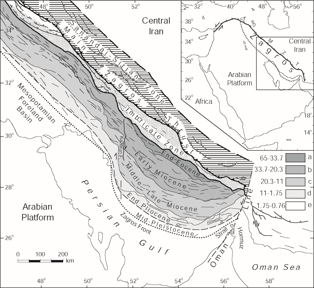
Figure 1: Different stages of the formation and migration of folding in the Zagros mountain range. The folding began in the late Eocene with the deformation of the north easternmost part of the folded Zagros and the migration of the sedimentary basin towards the southwest. In later stages (during the early Miocene, middle-late Miocene, late Pliocene, and mid-Pleistocene), other parts of the Zagros progressively underwent folding and faulting, and the sedimentary basin continued to migrate southwestward.

(Image editing: Masoumeh Rakhshandeh)
 IIEES All Rights Reserved

