سبد خرید خالی است.
خانه / مشخصات زلزله
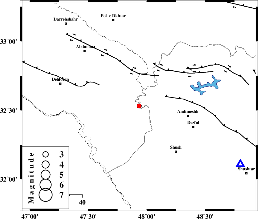
Magnitude |
:2.5 |
| Date & Time (UTC) | 2016-11-01 11:47:31.8 |
| Date & Time (Local) | 1395/8/11 15:17:31.8 |
| Location | Lat:32.532 Lon: 47.934 |
| Region | Ilam Province, 40 km -West of Andimeshk |
Nearest Cities |
|
| 34 km South West of Hoseinieh, Khoozestan Province | |
| 38 km South West of Bidruyeh, Khoozestan Province | |
| 40 km North West of Andimeshk, Khoozestan Province | |
| 46 km South West of Sorkhakan, Khoozestan Province | |
| 47 km North West of Dezful, Khoozestan Province | |
| Depth | 14 km |
| Agency | |
Faults within 150 km: |
|
| DEZFUL_EMBAYMENT (Length: 228 km) , Distance to epicenter: 22 km | |
| BALARUD_F_Z1 (Length: 87 km) , Distance to epicenter: 26 km | |
| BALARUD_F_Z3 (Length: 53 km) , Distance to epicenter: 35 km | |
| Number of Phases | 7 |
| RMS | 0.3 |
| Number of Stations | 6 |
| Error in Latitude | >9.9 km |
| Error in Longitude | 3.8 km |
| Error in Depth | 9 km |
Download waveform in seisan format
to download seisan software Click here
to access information about IIEES stations Click here
Amplitude | ||||||||
| UID | Agency | Station | Component | Amplitude | Period | Arrival Time | Proccessing Time | Signal Clip |
| 110476 | IIEES | SNGE | N | 17.8 | 0.68 | 2016-11-01 11:49:12 | 2016-11-02 04:59:00 | n |
| 110477 | IIEES | ASAO | N | 15.5 | 0.55 | 2016-11-01 11:49:05 | 2016-11-02 04:59:00 | n |
| 110478 | IIEES | GHVR | N | 6.8 | 0.54 | 2016-11-01 11:49:19 | 2016-11-02 04:59:00 | n |
| 110479 | IIEES | GHVR | E | 8.4 | 0.6 | 2016-11-01 11:49:28 | 2016-11-02 04:59:00 | n |
Phase | ||||||||||||
| Agency | Station | Component | Phase Type | Phase Quality | First Motion | Observed Arrival Time | Time Residual | Loc. Flag | Input Weight | Distance | Azimuth | |
| IIEES | ILBA | Z | Pg | E | 2016-11-01 11:48:04 | -0.42 | y | 202 | 307 | |||
| IIEES | KHMZ | Z | Pn | E | 2016-11-01 11:48:08 | -0.13 | y | 232 | 54 | |||
| IIEES | KHMZ | E | Sg | E | 2016-11-01 11:48:37 | -0.22 | y | 232 | 54 | |||
| IIEES | SNGE | Z | Pn | E | 2016-11-01 11:48:16 | 0.56 | y | 289 | 349 | |||
| IIEES | ASAO | Z | Pn | E | 2016-11-01 11:48:16 | 0.23 | y | 296 | 40 | |||
| IIEES | GHVR | Z | Pn | E | 2016-11-01 11:48:29 | 3.73 | n | 4 | 376 | 54 | ||
| IIEES | NASN | Z | Pn | E | 2016-11-01 11:48:36 | 0.04 | y | 458 | 85 | |||
کلیه حقوق مادی و معنوی این سایت متعلق به پژوهشگاه بین المللی زلزله شناسی و مهندسی زلزله می باشد.
