خانه / مشخصات زلزله
Magnitude |
:3.3 |
| Date & Time (UTC) | 2017-05-13 23:54:57.7 |
| Date & Time (Local) | 1396/2/24 04:24:57.7 |
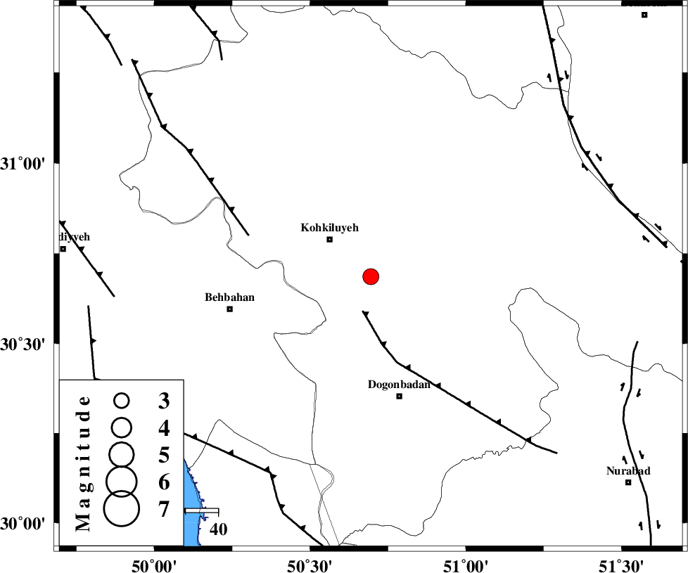
| Location | Lat:30.685 Lon: 50.695 |
| Region | Kohkiluieh va boyerahmad Province, 17 km South-East of Dehdasht |
Nearest Cities |
|
| 17 km South East of Dehdasht, Kohkiluieh va boyerahmad Province | |
| 24 km South of Savari, Kohkiluieh va boyerahmad Province | |
| 38 km North of Dogonbadan, Kohkiluieh va boyerahmad Province | |
| 38 km North East of Mansuriyeh, Khoozestan Province | |
| 42 km South East of Lendeh, Kohkiluieh va boyerahmad Province | |
| Depth | 46 km |
| Agency | |
Faults within 150 km: |
|
| MISHAN_F (Length: 76 km) , Distance to epicenter: 11 km | |
| MFF4 (Length: 62 km) , Distance to epicenter: 40 km | |
| RAG_E_SEFID_F (Length: 84 km) , Distance to epicenter: 68 km | |
| Number of Phases | 6 |
| RMS | 0.1 |
| Number of Stations | 3 |
| Error in Latitude | >1.1 km |
| Error in Longitude | 4.3 km |
| Error in Depth | 3.2 km |
Download waveform in seisan format
to download seisan software Click here
to access information about IIEES stations Click here
Amplitude | ||||||||
| UID | Agency | Station | Component | Amplitude | Period | Arrival Time | Proccessing Time | Signal Clip |
| 115886 | IIEES | AHRM | N | 281.3 | 0.64 | 2017-05-13 23:56:01 | 2017-05-14 05:00:00 | n |
| 115887 | IIEES | AHRM | E | 167.8 | 0.52 | 2017-05-13 23:56:01 | 2017-05-14 05:00:00 | n |
| 115888 | IIEES | GHIR | N | 85.1 | 0.61 | 2017-05-13 23:56:41 | 2017-05-14 05:00:00 | n |
Phase | ||||||||||||
| Agency | Station | Component | Phase Type | Phase Quality | First Motion | Observed Arrival Time | Time Residual | Loc. Flag | Input Weight | Distance | Azimuth | |
| IIEES | AHRM | Z | Pg | E | 2017-05-13 23:55:31 | 0.07 | y | 210 | 164 | |||
| IIEES | AHRM | E | Sg | E | 2017-05-13 23:55:56 | 0.01 | y | 210 | 164 | |||
| IIEES | NASN | Z | Pn | E | 2017-05-13 23:55:41 | 0.07 | y | 308 | 40 | |||
| IIEES | NASN | N | Sg | E | 2017-05-13 23:56:23 | 0 | y | 308 | 40 | |||
| IIEES | GHIR | Z | Pn | E | 2017-05-13 23:55:45 | -0.2 | y | 347 | 140 | |||
| IIEES | GHIR | E | Sg | E | 2017-05-13 23:56:32 | 0.05 | y | 347 | 140 | |||
کلیه حقوق مادی و معنوی این سایت متعلق به پژوهشگاه بین المللی زلزله شناسی و مهندسی زلزله می باشد.
