خانه / مشخصات زلزله
Magnitude |
:3.1 |
| Date & Time (UTC) | 2018-02-26 11:19:55.1 |
| Date & Time (Local) | 1396/12/7 14:49:55.1 |
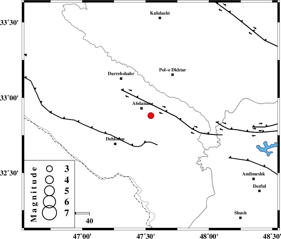
| Location | Lat:32.881 Lon: 47.541 |
| Region | Ilam Province, 9 km of Abdanan |
Nearest Cities |
|
| 3 km of Sarabbagh, Ilam Province | |
| 9 km of Abdanan, Ilam Province | |
| 28 km South West of Sarab hammam, Lorestan Province | |
| 34 km North East of Dehloran, Ilam Province | |
| 34 km South West of Pol-e dokhtar, Lorestan Province | |
| Depth | 14 km |
| Agency | |
Faults within 150 km: |
|
| BALARUD_F_Z1 (Length: 87 km) , Distance to epicenter: 19 km | |
| MFF6 (Length: 144 km) , Distance to epicenter: 20 km | |
| BALARUD_F_Z3 (Length: 53 km) , Distance to epicenter: 48 km | |
| Number of Phases | 5 |
| RMS | 0.1 |
| Number of Stations | 3 |
| Error in Latitude | >3.9 km |
| Error in Longitude | 3.9 km |
| Error in Depth | 8.5 km |
Download waveform in seisan format
to download seisan software Click here
to access information about IIEES stations Click here
Amplitude | ||||||||
| UID | Agency | Station | Component | Amplitude | Period | Arrival Time | Proccessing Time | Signal Clip |
| 129014 | IIEES | ILBA | N | 913.9 | 0.7 | 2018-02-26 11:20:43 | 2018-02-27 07:25:00 | n |
| 129015 | IIEES | SNGE | N | 52.6 | 0.6 | 2018-02-26 11:21:11 | 2018-02-27 07:25:00 | n |
| 129016 | IIEES | SNGE | E | 76.5 | 0.76 | 2018-02-26 11:21:12 | 2018-02-27 07:25:00 | n |
| 129017 | IIEES | ASAO | N | 49.4 | 0.57 | 2018-02-26 11:21:23 | 2018-02-27 07:25:00 | n |
| 129018 | IIEES | ASAO | E | 47.7 | 0.52 | 2018-02-26 11:21:29 | 2018-02-27 07:25:00 | n |
Phase | ||||||||||||
| Agency | Station | Component | Phase Type | Phase Quality | First Motion | Observed Arrival Time | Time Residual | Loc. Flag | Input Weight | Distance | Azimuth | |
| IIEES | ILBA | Z | Pg | E | 2018-02-26 11:20:19 | -0.24 | y | 149 | 304 | |||
| IIEES | ILBA | N | Sg | E | 2018-02-26 11:20:38 | 0.15 | y | 149 | 304 | |||
| IIEES | SNGE | Z | Pn | E | 2018-02-26 11:20:33 | 0.13 | y | 246 | 356 | |||
| IIEES | SNGE | N | Sg | E | 2018-02-26 11:21:04 | -0.08 | y | 246 | 356 | |||
| IIEES | ASAO | Z | Pn | E | 2018-02-26 11:20:39 | 0.03 | y | 295 | 51 | |||
کلیه حقوق مادی و معنوی این سایت متعلق به پژوهشگاه بین المللی زلزله شناسی و مهندسی زلزله می باشد.
