خانه / مشخصات زلزله
Magnitude |
:2.6 |
| Date & Time (UTC) | 2018-11-04 06:56:12.9 |
| Date & Time (Local) | 1397/8/13 10:26:12.9 |
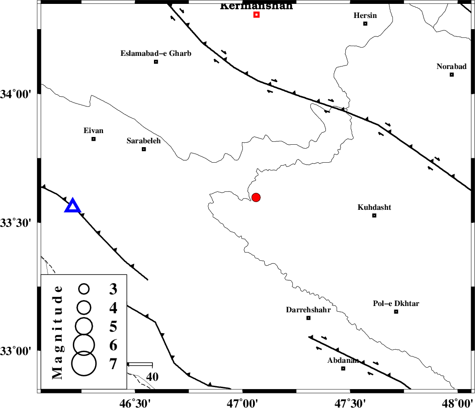
| Location | Lat:33.598 Lon: 47.062 |
| Region | Lorestan Province, 52 km -West of Kuhdasht |
Nearest Cities |
|
| 23 km North West of Garab, Lorestan Province | |
| 25 km East of Belaveh tare-e sofla, Ilam Province | |
| 34 km North West of Kunani, Lorestan Province | |
| 34 km East of Sartang-e malehmaran, Ilam Province | |
| 35 km South East of Qale-ye harsam, Kermanshah Province | |
| Depth | 14 km |
| Agency | |
Faults within 150 km: |
|
| HZF4 (Length: 492 km) , Distance to epicenter: 47 km | |
| MFF7 (Length: 99 km) , Distance to epicenter: 59 km | |
| BALARUD_F_Z1 (Length: 87 km) , Distance to epicenter: 65 km | |
| Number of Phases | 7 |
| RMS | 0.3 |
| Number of Stations | 5 |
| Error in Latitude | >4.2 km |
| Error in Longitude | 3.9 km |
| Error in Depth | 9 km |
Download waveform in seisan format
to download seisan software Click here
to access information about IIEES stations Click here
Amplitude | ||||||||
| UID | Agency | Station | Component | Amplitude | Period | Arrival Time | Proccessing Time | Signal Clip |
| 138251 | IIEES | ILBA | E | 192.2 | 0.39 | 2018-11-04 06:56:37 | 2018-11-04 08:43:00 | n |
| 138252 | IIEES | ILBA | N | 275.6 | 0.56 | 2018-11-04 06:56:48 | 2018-11-04 08:43:00 | n |
| 138253 | IIEES | SNGE | E | 111.2 | 0.84 | 2018-11-04 06:57:06 | 2018-11-04 08:43:00 | n |
| 138254 | IIEES | SNGE | N | 88.7 | 0.5 | 2018-11-04 06:57:06 | 2018-11-04 08:43:00 | n |
Phase | ||||||||||||
| Agency | Station | Component | Phase Type | Phase Quality | First Motion | Observed Arrival Time | Time Residual | Loc. Flag | Input Weight | Distance | Azimuth | |
| IIEES | ILBA | Z | Pg | E | 2018-11-04 06:56:26 | 0.21 | y | 79.4 | 272 | |||
| IIEES | ILBA | N | Sg | E | 2018-11-04 06:56:36 | -0.09 | y | 79.4 | 272 | |||
| IIEES | SNGE | Z | Pg | E | 2018-11-04 06:56:40 | -0.38 | y | 168 | 9 | |||
| IIEES | SNGE | N | Sg | E | 2018-11-04 06:57:01 | 0.16 | y | 168 | 9 | |||
| IIEES | KHMZ | Z | Pn | E | 2018-11-04 06:56:53 | -0.37 | y | 270 | 86 | |||
| IIEES | ASAO | Z | Pn | E | 2018-11-04 06:56:57 | 0.43 | y | 293 | 68 | |||
| IIEES | SRSL | Z | Pn | E | 2018-11-04 06:57:01 | 0.07 | y | 326 | 333 | |||
کلیه حقوق مادی و معنوی این سایت متعلق به پژوهشگاه بین المللی زلزله شناسی و مهندسی زلزله می باشد.
