خانه / مشخصات زلزله
Magnitude |
:2.7 |
| Date & Time (UTC) | 2018-11-12 05:15:42.2 |
| Date & Time (Local) | 1397/8/21 08:45:42.2 |
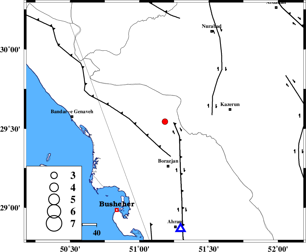
| Location | Lat:29.544 Lon: 51.184 |
| Region | Bushehr Province, 31 km North of Borazjan |
Nearest Cities |
|
| 15 km West of Khesht, Fars Province | |
| 16 km North West of Dalki, Bushehr Province | |
| 19 km North of Nazar aqa, Bushehr Province | |
| 19 km North of Saedabad, Bushehr Province | |
| 20 km North East of Dehkohneh, Bushehr Province | |
| Depth | 14 km |
| Agency | |
Faults within 150 km: |
|
| BORAZJAN_F (Length: 168 km) , Distance to epicenter: 6 km | |
| ZFF3 (Length: 125 km) , Distance to epicenter: 16 km | |
| KAZERUN_F (Length: 96 km) , Distance to epicenter: 33 km | |
| Number of Phases | 6 |
| RMS | 0.2 |
| Number of Stations | 4 |
| Error in Latitude | >3.2 km |
| Error in Longitude | 3.9 km |
| Error in Depth | 8.8 km |
Download waveform in seisan format
to download seisan software Click here
to access information about IIEES stations Click here
Amplitude | ||||||||
| UID | Agency | Station | Component | Amplitude | Period | Arrival Time | Proccessing Time | Signal Clip |
| 138343 | IIEES | GHIR | N | 87 | 0.75 | 2018-11-12 05:16:56 | 2018-11-12 09:26:00 | n |
| 138344 | IIEES | NASN | N | 6.9 | 0.28 | 2018-11-12 05:17:26 | 2018-11-12 09:26:00 | n |
Phase | ||||||||||||
| Agency | Station | Component | Phase Type | Phase Quality | First Motion | Observed Arrival Time | Time Residual | Loc. Flag | Input Weight | Distance | Azimuth | |
| IIEES | AHRM | Z | Pg | E | 2018-11-12 05:15:55 | -0.08 | y | 76 | 172 | |||
| IIEES | AHRM | N | Sg | E | 2018-11-12 05:16:04 | -0.04 | y | 76 | 172 | |||
| IIEES | GHIR | Z | Pn | E | 2018-11-12 05:16:18 | 0.38 | y | 224 | 128 | |||
| IIEES | GHIR | N | Sg | E | 2018-11-12 05:16:45 | -0.13 | y | 224 | 128 | |||
| IIEES | NASN | Z | Pn | E | 2018-11-12 05:16:38 | -0.17 | y | 393 | 23 | |||
| IIEES | YZKH | Z | Pn | E | 2018-11-12 05:16:46 | 0 | y | 453 | 45 | |||
کلیه حقوق مادی و معنوی این سایت متعلق به پژوهشگاه بین المللی زلزله شناسی و مهندسی زلزله می باشد.
