خانه / مشخصات زلزله
Magnitude |
:2.5 |
| Date & Time (UTC) | 2018-12-08 16:43:41.1 |
| Date & Time (Local) | 1397/9/17 20:13:41.1 |
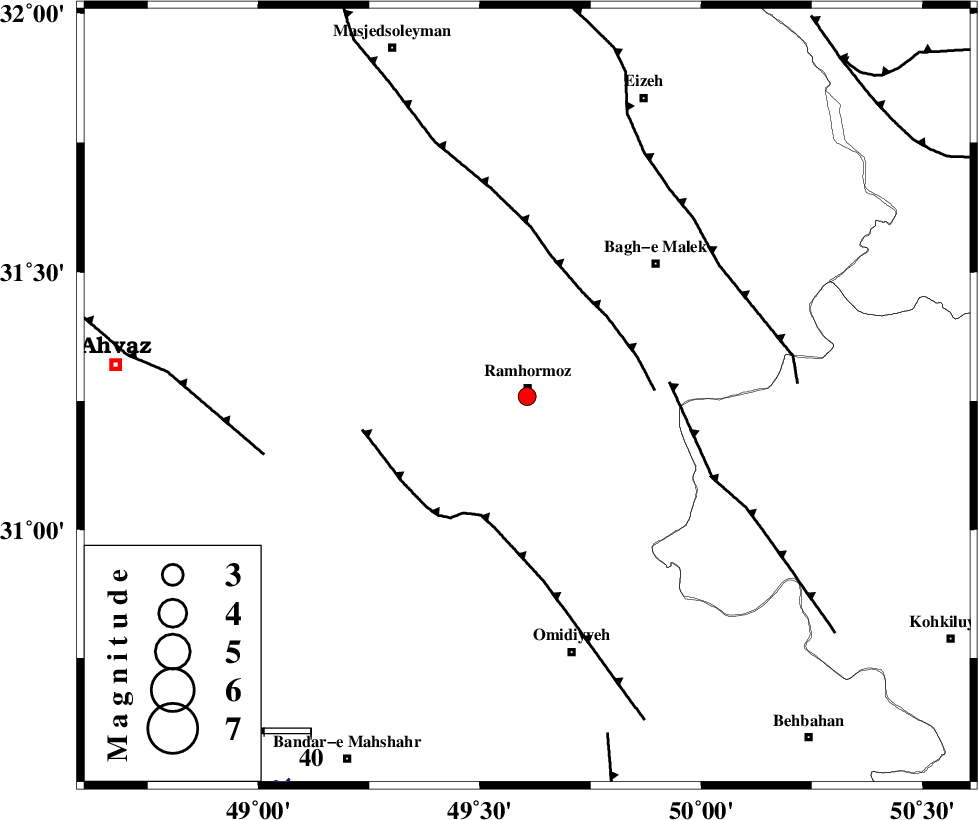
| Location | Lat:31.259 Lon: 49.607 |
| Region | Khoozestan Province, 2 km of Ramhormoz |
Nearest Cities |
|
| 2 km of Ramhormoz, Khoozestan Province | |
| 17 km East of Marbacheh, Khoozestan Province | |
| 22 km South of Haftgol, Khoozestan Province | |
| 23 km South West of Midavood-e sofla, Khoozestan Province | |
| 25 km North of Soltanabad, Khoozestan Province | |
| Depth | 15 km |
| Agency | |
Faults within 150 km: |
|
| DEZFUL_EMBAYMENT (Length: 228 km) , Distance to epicenter: 24 km | |
| AGHAJARI_F (Length: 88 km) , Distance to epicenter: 27 km | |
| MFF4 (Length: 62 km) , Distance to epicenter: 31 km | |
| Number of Phases | 6 |
| RMS | 0.2 |
| Number of Stations | 6 |
| Error in Latitude | >7.1 km |
| Error in Longitude | 2.1 km |
| Error in Depth | 0 km |
Download waveform in seisan format
to download seisan software Click here
to access information about IIEES stations Click here
Amplitude | ||||||||
| UID | Agency | Station | Component | Amplitude | Period | Arrival Time | Proccessing Time | Signal Clip |
| 139144 | IIEES | ASAO | N | 8 | 0.53 | 2018-12-08 16:45:40 | 2018-12-09 06:18:00 | n |
| 139145 | IIEES | GHVR | E | 6.9 | 0.73 | 2018-12-08 16:45:43 | 2018-12-09 06:18:00 | n |
Phase | ||||||||||||
| Agency | Station | Component | Phase Type | Phase Quality | First Motion | Observed Arrival Time | Time Residual | Loc. Flag | Input Weight | Distance | Azimuth | |
| IIEES | KHMZ | Z | Pn | E | 2018-12-08 16:44:23 | -0.27 | y | 277 | 7 | |||
| IIEES | NASN | Z | Pn | E | 2018-12-08 16:44:31 | -0.24 | y | 347 | 60 | |||
| IIEES | ASAO | Z | Pn | E | 2018-12-08 16:44:34 | 0.23 | y | 367 | 6 | |||
| IIEES | GHVR | Z | Pn | E | 2018-12-08 16:44:37 | 0.18 | y | 389 | 23 | |||
| IIEES | ILBA | Z | Pn | E | 2018-12-08 16:44:40 | -0.01 | y | 413 | 310 | |||
| IIEES | YZKH | Z | Pn | E | 2018-12-08 16:44:49 | 0.19 | y | 488 | 74 | |||
کلیه حقوق مادی و معنوی این سایت متعلق به پژوهشگاه بین المللی زلزله شناسی و مهندسی زلزله می باشد.
