خانه / مشخصات زلزله
Magnitude |
:2.5 |
| Date & Time (UTC) | 2018-12-13 11:13:19.0 |
| Date & Time (Local) | 1397/9/22 14:43:19.0 |
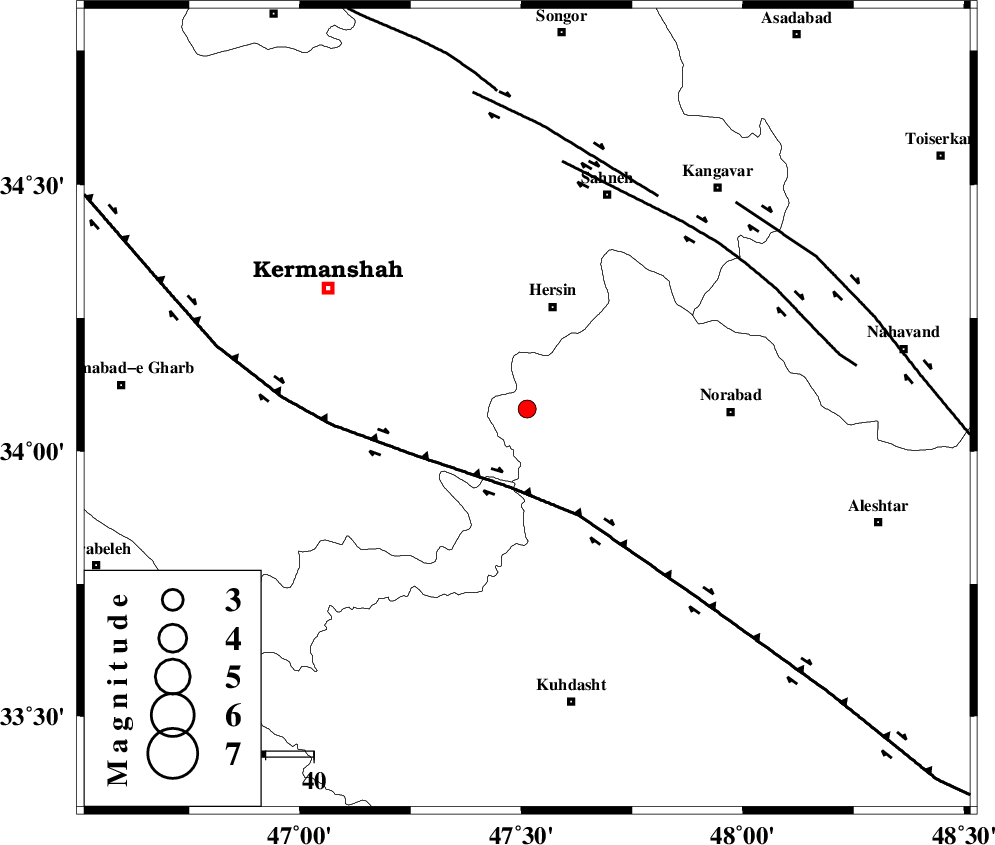
| Location | Lat:34.079 Lon: 47.513 |
| Region | Lorestan Province, 22 km South of Harsin |
Nearest Cities |
|
| 18 km South East of Cheshmeh kabud, Kermanshah Province | |
| 19 km North West of Kahrizvardasht-e olia, Lorestan Province | |
| 22 km South of Harsin, Kermanshah Province | |
| 27 km South West of Haftcheshmeh, Lorestan Province | |
| 33 km South of Bisotun, Kermanshah Province | |
| Depth | 6 km |
| Agency | |
Faults within 150 km: |
|
| HZF4 (Length: 492 km) , Distance to epicenter: 17 km | |
| SAHANEH_F (Length: 77 km) , Distance to epicenter: 51 km | |
| DINEHVAR_F (Length: 46 km) , Distance to epicenter: 52 km | |
| Number of Phases | 7 |
| RMS | 0.2 |
| Number of Stations | 5 |
| Error in Latitude | >2.5 km |
| Error in Longitude | 2.4 km |
| Error in Depth | 5.6 km |
Download waveform in seisan format
to download seisan software Click here
to access information about IIEES stations Click here
Amplitude | ||||||||
| UID | Agency | Station | Component | Amplitude | Period | Arrival Time | Proccessing Time | Signal Clip |
| 139394 | IIEES | SNGE | E | 86 | 0.71 | 2018-12-13 11:14:04 | 2018-12-17 07:22:00 | n |
| 139395 | IIEES | SNGE | N | 62.2 | 0.36 | 2018-12-13 11:14:04 | 2018-12-17 07:22:00 | n |
| 139396 | IIEES | ILBA | N | 168.8 | 0.34 | 2018-12-13 11:14:02 | 2018-12-17 07:22:00 | n |
| 139397 | IIEES | ILBA | E | 127 | 0.5 | 2018-12-13 11:14:04 | 2018-12-17 07:22:00 | n |
| 139398 | IIEES | GHVR | N | 14 | 0.47 | 2018-12-13 11:15:02 | 2018-12-17 07:22:00 | n |
| 139399 | IIEES | GHVR | E | 9.5 | 0.62 | 2018-12-13 11:15:05 | 2018-12-17 07:22:00 | n |
Phase | ||||||||||||
| Agency | Station | Component | Phase Type | Phase Quality | First Motion | Observed Arrival Time | Time Residual | Loc. Flag | Input Weight | Distance | Azimuth | |
| IIEES | SNGE | Z | Pg | E | 2018-12-13 11:13:38 | -0.22 | y | 114 | 352 | |||
| IIEES | SNGE | N | Sg | E | 2018-12-13 11:13:53 | 0.09 | y | 114 | 352 | |||
| IIEES | ILBA | Z | Pg | E | 2018-12-13 11:13:41 | 0.04 | y | 131 | 248 | |||
| IIEES | ILBA | N | S | E | 2018-12-13 11:13:57 | 0.02 | y | 131 | 248 | |||
| IIEES | KHMZ | Z | Pn | E | 2018-12-13 11:13:56 | -0.32 | y | 230 | 99 | |||
| IIEES | ASAO | Z | Pn | E | 2018-12-13 11:13:57 | 0.24 | y | 237 | 77 | |||
| IIEES | GHVR | Z | Pn | E | 2018-12-13 11:14:10 | 0.19 | y | 346 | 82 | |||
کلیه حقوق مادی و معنوی این سایت متعلق به پژوهشگاه بین المللی زلزله شناسی و مهندسی زلزله می باشد.
