خانه / مشخصات زلزله
Magnitude |
:3.2 |
| Date & Time (UTC) | 2018-12-28 19:56:56.8 |
| Date & Time (Local) | 1397/10/7 23:26:56.8 |
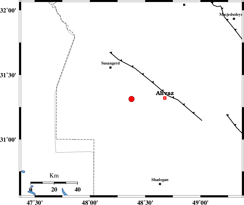
| Location | Lat:31.313 Lon: 48.376 |
| Region | Khoozestan Province, 29 km -West of Ahvaz |
Nearest Cities |
|
| 19 km South of Dehkade, Khoozestan Province | |
| 19 km South of Hamidiyeh, Khoozestan Province | |
| 22 km North West of Bahr, Khoozestan Province | |
| 27 km South East of Jalaliyeh, Khoozestan Province | |
| 29 km West of Ahvaz, Khoozestan Province | |
| Depth | 14 km |
| Agency | |
Faults within 150 km: |
|
| AHVAZ_F (Length: 99 km) , Distance to epicenter: 23 km | |
| AGHAJARI_F (Length: 88 km) , Distance to epicenter: 83 km | |
| DEZFUL_EMBAYMENT (Length: 228 km) , Distance to epicenter: 106 km | |
| Number of Phases | 6 |
| RMS | 0.3 |
| Number of Stations | 6 |
| Error in Latitude | >4.7 km |
| Error in Longitude | 3.5 km |
| Error in Depth | 0 km |
Download waveform in seisan format
to download seisan software Click here
to access information about IIEES stations Click here
Amplitude | ||||||||
| UID | Agency | Station | Component | Amplitude | Period | Arrival Time | Proccessing Time | Signal Clip |
| 139649 | IIEES | ILBA | N | 174.8 | 0.56 | 2018-12-28 19:58:41 | 2018-12-29 08:19:00 | n |
| 139650 | IIEES | ILBA | E | 110.2 | 0.56 | 2018-12-28 19:58:44 | 2018-12-29 08:19:00 | n |
| 139651 | IIEES | AHRM | E | 24.7 | 0.48 | 2018-12-28 19:59:07 | 2018-12-29 08:19:00 | n |
| 139652 | IIEES | AHRM | N | 21.4 | 0.48 | 2018-12-28 19:59:12 | 2018-12-29 08:19:00 | n |
| 139653 | IIEES | SNGE | N | 20.2 | 0.32 | 2018-12-28 19:58:47 | 2018-12-29 08:19:00 | n |
| 139654 | IIEES | GHVR | N | 14.4 | 0.27 | 2018-12-28 19:58:51 | 2018-12-29 08:19:00 | n |
Phase | ||||||||||||
| Agency | Station | Component | Phase Type | Phase Quality | First Motion | Observed Arrival Time | Time Residual | Loc. Flag | Input Weight | Distance | Azimuth | |
| IIEES | KHMZ | Z | Pn | E | 2018-12-28 19:57:43 | 0.36 | y | 308 | 29 | |||
| IIEES | ILBA | Z | Pn | E | 2018-12-28 19:57:45 | 0.28 | y | 328 | 322 | |||
| IIEES | ASAO | Z | Pn | E | 2018-12-28 19:57:53 | 0.15 | y | 391 | 23 | |||
| IIEES | AHRM | Z | Pn | E | 2018-12-28 19:57:52 | -0.04 | y | 391 | 133 | |||
| IIEES | SNGE | Z | Pn | E | 2018-12-28 19:57:57 | -0.6 | y | 430 | 347 | |||
| IIEES | GHVR | Z | Pn | E | 2018-12-28 19:57:59 | -0.3 | y | 442 | 37 | |||
کلیه حقوق مادی و معنوی این سایت متعلق به پژوهشگاه بین المللی زلزله شناسی و مهندسی زلزله می باشد.
