خانه / مشخصات زلزله
Magnitude |
:2.9 |
| Date & Time (UTC) | 2018-12-29 02:38:41.6 |
| Date & Time (Local) | 1397/10/8 06:08:41.6 |
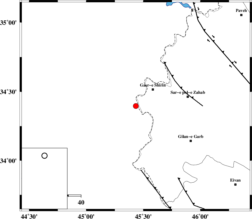
| Location | Lat:34.396 Lon: 45.434 |
| Region | Iraq, 19 km South-West of Qasr-E-Shirin |
Nearest Cities |
|
| 4 km of Khosravi, Kermanshah Province | |
| 16 km West of Seyyed sohrab, Kermanshah Province | |
| 19 km South West of Qasr-E-Shirin, Kermanshah Province | |
| 27 km South West of Aqabarar, Kermanshah Province | |
| 33 km West of Qareh belagh, Kermanshah Province | |
| Depth | 15 km |
| Agency | |
Faults within 150 km: |
|
| MFF8 (Length: 48 km) , Distance to epicenter: 37 km | |
| ZFF4 (Length: 128 km) , Distance to epicenter: 52 km | |
| MFF7 (Length: 99 km) , Distance to epicenter: 67 km | |
| Number of Phases | 7 |
| RMS | 0.3 |
| Number of Stations | 5 |
| Error in Latitude | >3.1 km |
| Error in Longitude | 5.5 km |
| Error in Depth | 7.2 km |
Download waveform in seisan format
to download seisan software Click here
to access information about IIEES stations Click here
Amplitude | ||||||||
| UID | Agency | Station | Component | Amplitude | Period | Arrival Time | Proccessing Time | Signal Clip |
| 139678 | IIEES | ILBA | N | 194.3 | 0.36 | 2018-12-29 02:39:22 | 2018-12-30 07:11:00 | n |
| 139679 | IIEES | SNGE | E | 106.8 | 0.49 | 2018-12-29 02:39:40 | 2018-12-30 07:11:00 | n |
| 139680 | IIEES | SNGE | N | 101.7 | 0.43 | 2018-12-29 02:39:40 | 2018-12-30 07:11:00 | n |
| 139681 | IIEES | SRSL | E | 103.3 | 0.42 | 2018-12-29 02:39:40 | 2018-12-30 07:11:00 | n |
| 139682 | IIEES | SRSL | N | 148.2 | 0.58 | 2018-12-29 02:39:42 | 2018-12-30 07:11:00 | n |
Phase | ||||||||||||
| Agency | Station | Component | Phase Type | Phase Quality | First Motion | Observed Arrival Time | Time Residual | Loc. Flag | Input Weight | Distance | Azimuth | |
| IIEES | ILBA | Z | Pg | E | 2018-12-29 02:39:00 | 0.23 | y | 111 | 140 | |||
| IIEES | SNGE | Z | Pg | E | 2018-12-29 02:39:12 | -0.69 | y | 192 | 66 | |||
| IIEES | SNGE | N | Sg | E | 2018-12-29 02:39:36 | 0.24 | y | 192 | 66 | |||
| IIEES | SRSL | Z | Pn | E | 2018-12-29 02:39:14 | -0.15 | y | 202 | 0 | |||
| IIEES | SRSL | N | Sg | E | 2018-12-29 02:39:39 | 0.22 | y | 202 | 0 | |||
| IIEES | ZNJK | Z | Pn | E | 2018-12-29 02:39:37 | 0.04 | y | 388 | 49 | |||
| IIEES | ASAO | Z | Pn | E | 2018-12-29 02:39:42 | 0.15 | y | 422 | 86 | |||
کلیه حقوق مادی و معنوی این سایت متعلق به پژوهشگاه بین المللی زلزله شناسی و مهندسی زلزله می باشد.
