خانه / مشخصات زلزله
Magnitude |
:2.8 |
| Date & Time (UTC) | 2019-01-13 02:07:42.0 |
| Date & Time (Local) | 1397/10/23 05:37:42.0 |
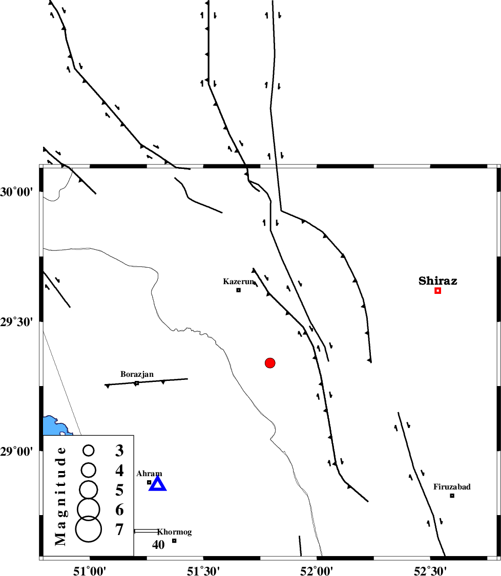
| Location | Lat:29.34 Lon: 51.793 |
| Region | Fars Province, 34 km South-East of Kazerun |
Nearest Cities |
|
| 7 km North of Dadin-e olia, Fars Province | |
| 16 km North West of Baladeh, Fars Province | |
| 22 km North West of Jareh, Fars Province | |
| 27 km South East of Mehranjan, Fars Province | |
| 29 km South of Kalani, Fars Province | |
| Depth | 16 km |
| Agency | |
Faults within 150 km: |
|
| KAREBASS_F (Length: 98 km) , Distance to epicenter: 35 km | |
| KAZERUN_F (Length: 96 km) , Distance to epicenter: 38 km | |
| BORAZJAN_F (Length: 168 km) , Distance to epicenter: 49 km | |
| Number of Phases | 7 |
| RMS | 0.1 |
| Number of Stations | 5 |
| Error in Latitude | >3.2 km |
| Error in Longitude | 1.2 km |
| Error in Depth | 7.9 km |
Download waveform in seisan format
to download seisan software Click here
to access information about IIEES stations Click here
Amplitude | ||||||||
| UID | Agency | Station | Component | Amplitude | Period | Arrival Time | Proccessing Time | Signal Clip |
| 140145 | IIEES | GHIR | N | 103.3 | 0.4 | 2019-01-13 02:08:38 | 2019-01-14 06:29:00 | n |
| 140146 | IIEES | KRBR | N | 8.5 | 0.31 | 2019-01-13 02:09:44 | 2019-01-14 06:29:00 | n |
| 140147 | IIEES | KRBR | E | 8.4 | 0.48 | 2019-01-13 02:09:44 | 2019-01-14 06:29:00 | n |
Phase | ||||||||||||
| Agency | Station | Component | Phase Type | Phase Quality | First Motion | Observed Arrival Time | Time Residual | Loc. Flag | Input Weight | Distance | Azimuth | |
| IIEES | AHRM | Z | Pg | E | 2019-01-13 02:07:54 | 0 | y | 71.4 | 223 | |||
| IIEES | AHRM | N | Sg | E | 2019-01-13 02:08:03 | 0 | y | 71.4 | 223 | |||
| IIEES | GHIR | Z | Pg | E | 2019-01-13 02:08:09 | 0.08 | y | 165 | 135 | |||
| IIEES | GHIR | N | Sg | E | 2019-01-13 02:08:29 | -0.08 | y | 165 | 135 | |||
| IIEES | NASN | Z | Pn | E | 2019-01-13 02:08:38 | -0.1 | y | 396 | 14 | |||
| IIEES | YZKH | Z | Pn | E | 2019-01-13 02:08:43 | 0.03 | y | 431 | 38 | |||
| IIEES | KRBR | Z | Pn | E | 2019-01-13 02:08:50 | 0.08 | y | 486 | 80 | |||
کلیه حقوق مادی و معنوی این سایت متعلق به پژوهشگاه بین المللی زلزله شناسی و مهندسی زلزله می باشد.
