خانه / مشخصات زلزله
Magnitude |
:2.9 |
| Date & Time (UTC) | 2019-01-19 11:22:00.4 |
| Date & Time (Local) | 1397/10/29 14:52:00.4 |
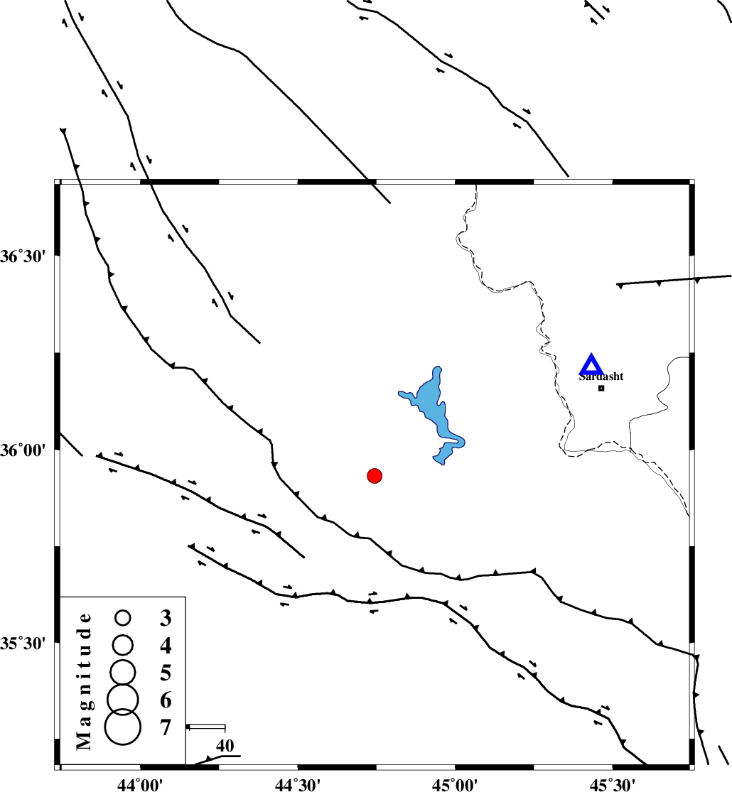
| Location | Lat:35.932 Lon: 44.744 |
| Region | Iraq, 69 km South-West of Sardasht |
Nearest Cities |
|
| 63 km South West of Bivaran-e sofla, Azarbaijan Gharbi Province | |
| 69 km South West of Sardasht, Azarbaijan Gharbi Province | |
| 75 km North West of Sulaymaniyah, Iraq Province | |
| 75 km South West of Felas, Azarbaijan Gharbi Province | |
| 76 km South West of Bersiv, Azarbaijan Gharbi Province | |
| Depth | 14 km |
| Agency | |
Faults within 150 km: |
|
| PIRANSHAHR_F (Length: 253 km) , Distance to epicenter: 77 km | |
| HZF4 (Length: 492 km) , Distance to epicenter: 91 km | |
| Number of Phases | 6 |
| RMS | 0.2 |
| Number of Stations | 4 |
| Error in Latitude | >3.5 km |
| Error in Longitude | 6.9 km |
| Error in Depth | 6.8 km |
Download waveform in seisan format
to download seisan software Click here
to access information about IIEES stations Click here
Amplitude | ||||||||
| UID | Agency | Station | Component | Amplitude | Period | Arrival Time | Proccessing Time | Signal Clip |
| 140420 | IIEES | SRSL | N | 472.8 | 0.39 | 2019-01-19 11:22:25 | 2019-01-19 12:03:00 | n |
| 140421 | IIEES | SRSL | E | 770.8 | 0.33 | 2019-01-19 11:22:25 | 2019-01-19 12:03:00 | n |
Phase | ||||||||||||
| Agency | Station | Component | Phase Type | Phase Quality | First Motion | Observed Arrival Time | Time Residual | Loc. Flag | Input Weight | Distance | Azimuth | |
| IIEES | SRSL | Z | Pg | E | 2019-01-19 11:22:12 | -0.21 | y | 69.5 | 63 | |||
| IIEES | SNGE | Z | Pn | E | 2019-01-19 11:22:39 | -0.12 | y | 254 | 111 | |||
| IIEES | SNGE | N | Sg | E | 2019-01-19 11:23:12 | 0.06 | y | 254 | 111 | |||
| IIEES | ILBA | Z | Pn | E | 2019-01-19 11:22:44 | 0.09 | y | 289 | 152 | |||
| IIEES | ILBA | N | S | E | 2019-01-19 11:23:15 | -0.09 | y | 289 | 152 | |||
| IIEES | ZNJK | Z | Pn | E | 2019-01-19 11:22:53 | 0.32 | y | 363 | 76 | |||
کلیه حقوق مادی و معنوی این سایت متعلق به پژوهشگاه بین المللی زلزله شناسی و مهندسی زلزله می باشد.
