خانه / مشخصات زلزله
Magnitude |
:3 |
| Date & Time (UTC) | 2019-01-23 18:48:48.2 |
| Date & Time (Local) | 1397/11/3 22:18:48.2 |
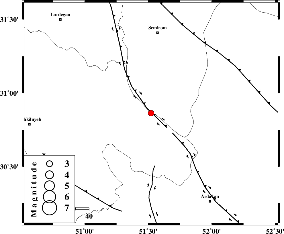
| Location | Lat:30.864 Lon: 51.522 |
| Region | Kohkiluieh va boyerahmad Province, 6 km of Sisakht |
Nearest Cities |
|
| 6 km of Sisakht, Kohkiluieh va boyerahmad Province | |
| 11 km North East of Kerik, Kohkiluieh va boyerahmad Province | |
| 22 km North of Yasuj, Kohkiluieh va boyerahmad Province | |
| 23 km North East of Chitab, Kohkiluieh va boyerahmad Province | |
| 23 km South of Kameh, Esfahan Province | |
| Depth | 15 km |
| Agency | |
Faults within 150 km: |
|
| DENA_F (Length: 137 km) , Distance to epicenter: 5 km | |
| HZF3 (Length: 197 km) , Distance to epicenter: 22 km | |
| KAZERUN_F (Length: 96 km) , Distance to epicenter: 40 km | |
| Number of Phases | 9 |
| RMS | 0.5 |
| Number of Stations | 9 |
| Error in Latitude | >3.5 km |
| Error in Longitude | 4.5 km |
| Error in Depth | 0 km |
Download waveform in seisan format
to download seisan software Click here
to access information about IIEES stations Click here
Amplitude | ||||||||
| UID | Agency | Station | Component | Amplitude | Period | Arrival Time | Proccessing Time | Signal Clip |
| 140512 | IIEES | AHRM | N | 97.9 | 0.71 | 2019-01-23 18:50:06 | 2019-01-26 11:57:00 | n |
| 140513 | IIEES | GHIR | N | 39.8 | 0.52 | 2019-01-23 18:50:27 | 2019-01-26 11:57:00 | n |
| 140514 | IIEES | GHVR | N | 17.9 | 0.61 | 2019-01-23 18:51:03 | 2019-01-26 11:57:00 | n |
Phase | ||||||||||||
| Agency | Station | Component | Phase Type | Phase Quality | First Motion | Observed Arrival Time | Time Residual | Loc. Flag | Input Weight | Distance | Azimuth | |
| IIEES | AHRM | Z | Pn | E | 2019-01-23 18:49:23 | 0.55 | y | 223 | 186 | |||
| IIEES | NASN | Z | Pn | E | 2019-01-23 18:49:26 | 0.02 | y | 247 | 29 | |||
| IIEES | GHIR | Z | Pn | E | 2019-01-23 18:49:34 | -0.71 | y | 319 | 153 | |||
| IIEES | YZKH | Z | Pn | E | 2019-01-23 18:49:38 | 0.27 | y | 337 | 59 | |||
| IIEES | GHVR | Z | Pn | E | 2019-01-23 18:49:45 | 0.15 | y | 402 | 356 | |||
| IIEES | ASAO | Z | Pn | E | 2019-01-23 18:49:50 | 0.37 | y | 432 | 341 | |||
| IIEES | DAMV | Z | Pn | E | 2019-01-23 18:50:01 | -0.83 | y | 530 | 4 | |||
| IIEES | ILBA | Z | Pn | E | 2019-01-23 18:50:08 | -0.3 | y | 587 | 303 | |||
| IIEES | TABS | Z | Pn | E | 2019-01-23 18:50:12 | 0.27 | y | 611 | 58 | |||
کلیه حقوق مادی و معنوی این سایت متعلق به پژوهشگاه بین المللی زلزله شناسی و مهندسی زلزله می باشد.
