خانه / مشخصات زلزله
Magnitude |
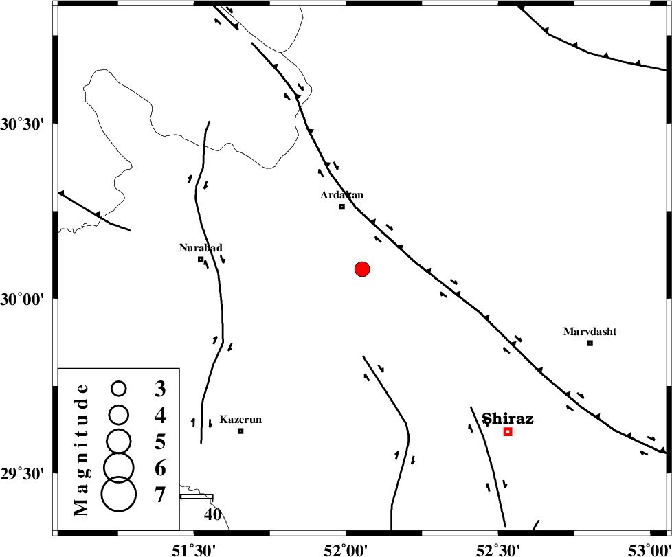
:3.1 |
| Date & Time (UTC) | 2019-02-18 18:58:46.8 |
| Date & Time (Local) | 1397/11/29 22:28:46.8 |
| Location | Lat:30.084 Lon: 52.053 |
| Region | Fars Province, 21 km South of Ardakan |
Nearest Cities |
|
| 15 km South of Bahrghan, Fars Province | |
| 21 km South of Ardakan, Fars Province | |
| 35 km West of Banesh, Fars Province | |
| 36 km North West of Baiza, Fars Province | |
| 39 km South West of Dorudzan, Fars Province | |
| Depth | 6 km |
| Agency | |
Faults within 150 km: |
|
| HZF3 (Length: 197 km) , Distance to epicenter: 17 km | |
| KAREBASS_F (Length: 98 km) , Distance to epicenter: 28 km | |
| KAZERUN_F (Length: 96 km) , Distance to epicenter: 46 km | |
| Number of Phases | 8 |
| RMS | 0.1 |
| Number of Stations | 7 |
| Error in Latitude | >3.9 km |
| Error in Longitude | 2.7 km |
| Error in Depth | 8.3 km |
Download waveform in seisan format
to download seisan software Click here
to access information about IIEES stations Click here
Amplitude | ||||||||
| UID | Agency | Station | Component | Amplitude | Period | Arrival Time | Proccessing Time | Signal Clip |
| 141238 | IIEES | AHRM | N | 310.2 | 0.67 | 2019-02-18 18:59:36 | 2019-02-20 08:55:00 | n |
| 141239 | IIEES | GHVR | N | 15.9 | 0.33 | 2019-02-18 19:00:51 | 2019-02-20 08:55:00 | n |
| 141240 | IIEES | GHVR | E | 14.3 | 0.33 | 2019-02-18 19:00:51 | 2019-02-20 08:55:00 | n |
Phase | ||||||||||||
| Agency | Station | Component | Phase Type | Phase Quality | First Motion | Observed Arrival Time | Time Residual | Loc. Flag | Input Weight | Distance | Azimuth | |
| IIEES | AHRM | Z | EPg | E | 2019-02-18 18:59:13 | -0.05 | y | 154 | 209 | |||
| IIEES | NASN | Z | EPn | E | 2019-02-18 18:59:34 | -0.01 | y | 310 | 13 | |||
| IIEES | YZKH | Z | EPn | E | 2019-02-18 18:59:39 | -0.16 | y | 352 | 43 | |||
| IIEES | KHMZ | Z | EPn | E | 2019-02-18 18:59:51 | 0.14 | y | 451 | 335 | |||
| IIEES | KRBR | Z | EPn | E | 2019-02-18 18:59:52 | 0.15 | y | 454 | 90 | |||
| IIEES | GHVR | Z | EPn | E | 2019-02-18 18:59:56 | 0.03 | y | 493 | 351 | |||
| IIEES | GHVR | N | ES | E | 2019-02-18 19:00:47 | -0.07 | y | 493 | 351 | |||
| IIEES | ASAO | Z | EPn | E | 2019-02-18 19:00:01 | 0.03 | y | 531 | 339 | |||
کلیه حقوق مادی و معنوی این سایت متعلق به پژوهشگاه بین المللی زلزله شناسی و مهندسی زلزله می باشد.
