خانه / مشخصات زلزله
Magnitude |
:3.2 |
| Date & Time (UTC) | 2019-03-10 17:17:28.0 |
| Date & Time (Local) | 1397/12/19 20:47:28.0 |
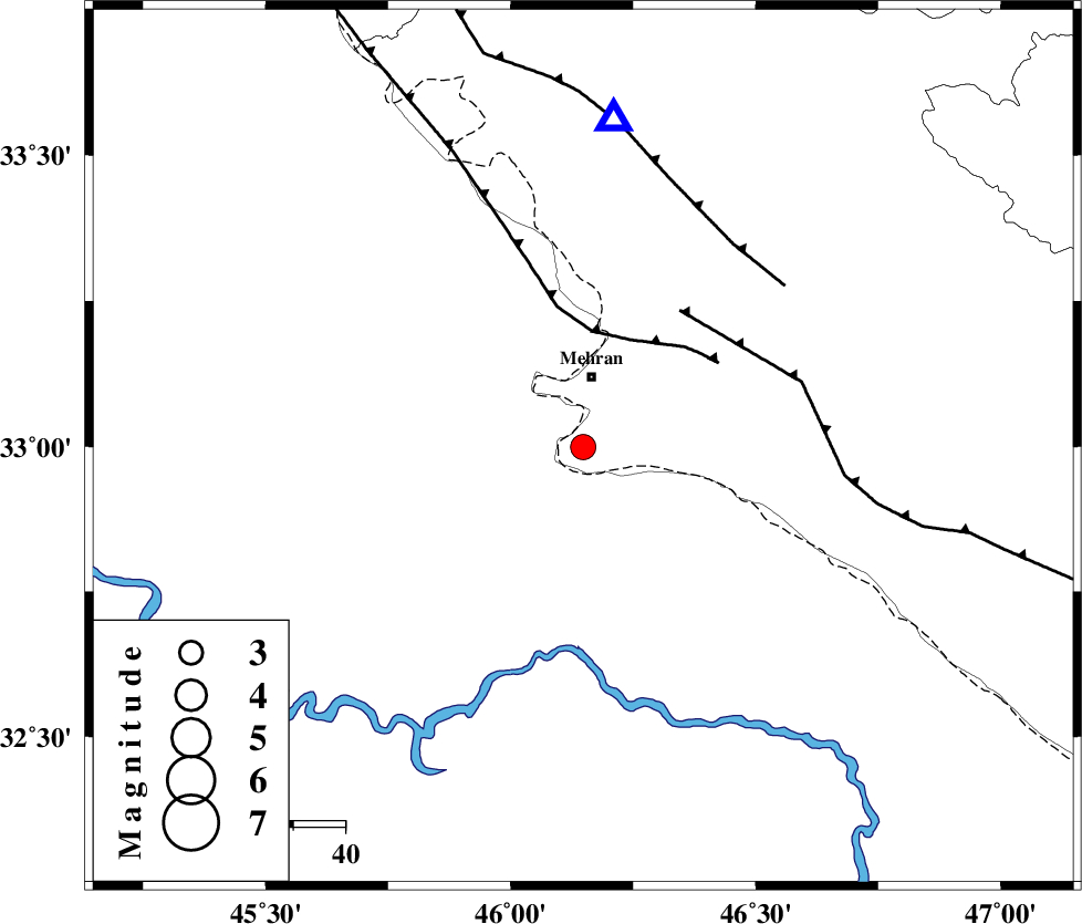
| Location | Lat:32.999 Lon: 46.148 |
| Region | Ilam Province, 14 km South of Mehran |
Nearest Cities |
|
| 14 km South of Mehran, Ilam Province | |
| 46 km South West of Galeh-yedarre-hemalakshahi, Ilam Province | |
| 47 km South West of Gonbad-e pirmohammad, Ilam Province | |
| 53 km South of Salehabad, Ilam Province | |
| 58 km South West of Mehr, Ilam Province | |
| Depth | 14 km |
| Agency | |
Faults within 150 km: |
|
| ZFF4 (Length: 128 km) , Distance to epicenter: 22 km | |
| MFF6 (Length: 144 km) , Distance to epicenter: 32 km | |
| MFF7 (Length: 99 km) , Distance to epicenter: 48 km | |
| Number of Phases | 7 |
| RMS | 0.2 |
| Number of Stations | 5 |
| Error in Latitude | >6.2 km |
| Error in Longitude | 5.2 km |
| Error in Depth | 9.8 km |
Download waveform in seisan format
to download seisan software Click here
to access information about IIEES stations Click here
Amplitude | ||||||||
| UID | Agency | Station | Component | Amplitude | Period | Arrival Time | Proccessing Time | Signal Clip |
| 141554 | IIEES | ILBA | E | 1744.6 | 0.68 | 2019-03-10 17:18:04 | 2019-03-11 05:03:00 | n |
| 141555 | IIEES | SNGE | E | 87.3 | 0.57 | 2019-03-10 17:18:49 | 2019-03-11 05:03:00 | n |
| 141556 | IIEES | SNGE | N | 84.2 | 0.52 | 2019-03-10 17:18:49 | 2019-03-11 05:03:00 | n |
| 141557 | IIEES | SRSL | E | 50.4 | 0.61 | 2019-03-10 17:19:23 | 2019-03-11 05:03:00 | n |
| 141558 | IIEES | SRSL | N | 60.6 | 0.4 | 2019-03-10 17:19:24 | 2019-03-11 05:03:00 | n |
Phase | ||||||||||||
| Agency | Station | Component | Phase Type | Phase Quality | First Motion | Observed Arrival Time | Time Residual | Loc. Flag | Input Weight | Distance | Azimuth | |
| IIEES | ILBA | Z | EPg | E | 2019-03-10 17:17:40 | -0.16 | y | 69.6 | 5 | |||
| IIEES | SNGE | Z | EPn | E | 2019-03-10 17:18:08 | 0.42 | y | 257 | 25 | |||
| IIEES | SNGE | N | ESg | E | 2019-03-10 17:18:40 | -0.05 | y | 257 | 25 | |||
| IIEES | SRSL | Z | EPn | E | 2019-03-10 17:18:20 | -0.21 | y | 362 | 350 | |||
| IIEES | SRSL | N | ESg | E | 2019-03-10 17:19:09 | 0.1 | y | 362 | 350 | |||
| IIEES | KHMZ | Z | EPn | E | 2019-03-10 17:18:20 | -0.29 | y | 364 | 76 | |||
| IIEES | ASAO | Z | EPn | E | 2019-03-10 17:18:25 | 0.16 | y | 398 | 63 | |||
کلیه حقوق مادی و معنوی این سایت متعلق به پژوهشگاه بین المللی زلزله شناسی و مهندسی زلزله می باشد.
