خانه / مشخصات زلزله
Magnitude |
:2.6 |
| Date & Time (UTC) | 2019-10-12 20:53:26.1 |
| Date & Time (Local) | 1398/7/21 00:23:26.1 |
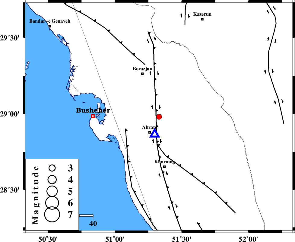
| Location | Lat:28.98 Lon: 51.33 |
| Region | Bushehr Province, 13 km North of Ahram |
Nearest Cities |
|
| 7 km North of Bazuei, Bushehr Province | |
| 13 km North West of Kalameh, Bushehr Province | |
| 13 km North of Ahram, Bushehr Province | |
| 26 km South East of Sarkareh, Bushehr Province | |
| 29 km East of Choghadak, Bushehr Province | |
| Depth | 5 km |
| Agency | |
Faults within 150 km: |
|
| BORAZJAN_F (Length: 168 km) , Distance to epicenter: 7 km | |
| MFF5 (Length: 74 km) , Distance to epicenter: 20 km | |
| ZFF2 (Length: 84 km) , Distance to epicenter: 26 km | |
| Number of Phases | 6 |
| RMS | 0.2 |
| Number of Stations | 4 |
| Error in Latitude | >0 km |
| Error in Longitude | 0 km |
| Error in Depth | 0 km |
Download waveform in seisan format
to download seisan software Click here
to access information about IIEES stations Click here
Amplitude | ||||||||
| UID | Agency | Station | Component | Amplitude | Period | Arrival Time | Proccessing Time | Signal Clip |
| 146528 | IIEES SC | AHRM | Z | 4400 | 1 | 2019-10-12 20:53:31 | 2019-10-13 02:16:00 | n |
| 146529 | IIEES SC | GHIR | Z | 15 | 1 | 2019-10-12 20:54:29 | 2019-10-13 02:16:00 | n |
| 146530 | IIEES SC | KLNJ | Z | 27 | 1 | 2019-10-12 20:54:42 | 2019-10-13 02:16:00 | n |
| 146531 | IIEES SC | YZKH | Z | 10 | 1 | 2019-10-12 20:54:54 | 2019-10-13 02:16:00 | n |
Phase | ||||||||||||
| Agency | Station | Component | Phase Type | Phase Quality | First Motion | Observed Arrival Time | Time Residual | Loc. Flag | Input Weight | Distance | Azimuth | |
| IIEES SC | AHRM | Z | IP | I | 2019-10-12 20:53:28 | -0.1 | y | 11 | 194 | |||
| IIEES SC | GHIR | Z | IP | I | 2019-10-12 20:53:56 | 0.1 | y | 177 | 115 | |||
| IIEES SC | KLNJ | N | IP | I | 2019-10-12 20:54:03 | 0.2 | y | 222 | 6 | |||
| IIEES SC | YZKH | Z | IP | I | 2019-10-12 20:54:35 | -0.5 | y | 489 | 40 | |||
| IIEES SC | AHRM | 2053 | 2019-10-12 20:53:41 | y | 11 | 194 | ||||||
| IIEES SC | GHIR | 2054 | 2019-10-12 20:54:35 | y | 177 | 115 | ||||||
کلیه حقوق مادی و معنوی این سایت متعلق به پژوهشگاه بین المللی زلزله شناسی و مهندسی زلزله می باشد.
