خانه / مشخصات زلزله
Magnitude |
:3.4 |
| Date & Time (UTC) | 2021-02-21 11:22:57.3 |
| Date & Time (Local) | 1399/12/3 14:52:57.3 |
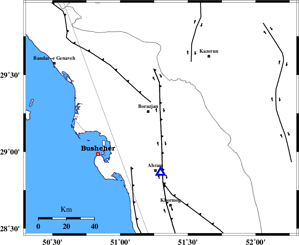
| Location | Lat:29.218 Lon: 51.302 |
| Region | Bushehr Province, 11 km of Borazjan |
Nearest Cities |
|
| 10 km North of Sarkareh, Bushehr Province | |
| 11 km of Borazjan, Bushehr Province | |
| 21 km South East of Nazar aqa, Bushehr Province | |
| 23 km East of Ziyarat, Bushehr Province | |
| 24 km South of Dalki, Bushehr Province | |
| Depth | 13 km |
| Agency | |
Faults within 150 km: |
|
| BORAZJAN_F (Length: 168 km) , Distance to epicenter: 5 km | |
| ZFF3 (Length: 125 km) , Distance to epicenter: 14 km | |
| ZFF2 (Length: 84 km) , Distance to epicenter: 41 km | |
| Number of Phases | 8 |
| RMS | 0.2 |
| Number of Stations | 8 |
| Error in Latitude | >2.4 km |
| Error in Longitude | 2.4 km |
| Error in Depth | 5 km |
Download waveform in seisan format
to download seisan software Click here
to access information about IIEES stations Click here
Amplitude | ||||||||
| UID | Agency | Station | Component | Amplitude | Period | Arrival Time | Proccessing Time | Signal Clip |
| 162105 | IIEES SC | KLNJ | Z | 0.6 | 1 | 2021-02-21 11:23:30 | 2021-02-23 06:29:00 | n |
| 162106 | IIEES SC | AMIS | Z | 0.4 | 1 | 2021-02-21 11:23:46 | 2021-02-23 06:29:00 | n |
| 162107 | IIEES SC | NASN | Z | 0.03 | 1 | 2021-02-21 11:23:57 | 2021-02-23 06:29:00 | n |
| 162108 | IIEES SC | ASAO | Z | 0.04 | 1 | 2021-02-21 11:24:20 | 2021-02-23 06:29:00 | n |
Phase | ||||||||||||
| Agency | Station | Component | Phase Type | Phase Quality | First Motion | Observed Arrival Time | Time Residual | Loc. Flag | Input Weight | Distance | Azimuth | |
| IIEES SC | AHRM | Z | EPg | E | 2021-02-21 11:23:04 | 0 | y | 0 | 39 | 181 | ||
| IIEES SC | KLNJ | Z | EPn | E | 2021-02-21 11:23:30 | 0.4 | y | 0 | 200 | 8 | ||
| IIEES SC | AMIS | Z | EPn | E | 2021-02-21 11:23:46 | 0.1 | y | 0 | 333 | 324 | ||
| IIEES SC | GTMR | Z | EPn | E | 2021-02-21 11:23:56 | -0.1 | y | 0 | 417 | 330 | ||
| IIEES SC | NASN | Z | EPn | E | 2021-02-21 11:23:57 | -0.6 | y | 0 | 422 | 20 | ||
| IIEES SC | YZKH | Z | EPn | E | 2021-02-21 11:24:03 | -0.1 | y | 0 | 472 | 42 | ||
| IIEES SC | KRBR | Z | EPn | E | 2021-02-21 11:24:06 | -5.8 | n | 4 | 536 | 81 | ||
| IIEES SC | ASAO | Z | EPn | E | 2021-02-21 11:24:20 | 0.2 | y | 0 | 603 | 348 | ||
کلیه حقوق مادی و معنوی این سایت متعلق به پژوهشگاه بین المللی زلزله شناسی و مهندسی زلزله می باشد.
