خانه / مشخصات زلزله
Magnitude |
:2.8 |
| Date & Time (UTC) | 2021-05-31 05:11:28.2 |
| Date & Time (Local) | 1400/3/10 09:41:28.2 |
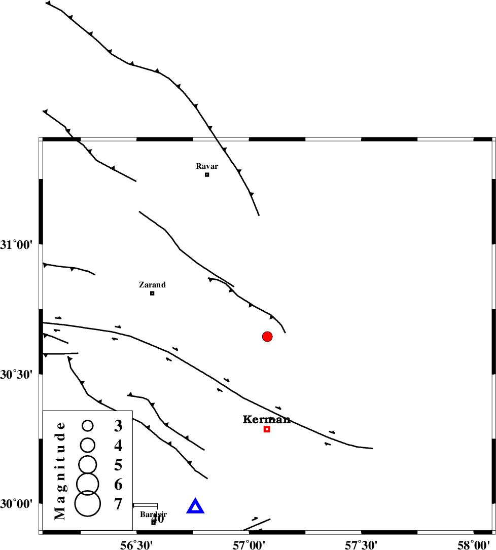
| Location | Lat:30.645 Lon: 57.081 |
| Region | Kerman Province, 40 km North of Kerman |
Nearest Cities |
|
| 5 km of Harjand, Kerman Province | |
| 16 km North East of Hutak, Kerman Province | |
| 16 km South East of Hejdak, Kerman Province | |
| 17 km North East of Chatrud, Kerman Province | |
| 24 km North East of Kazemabad, Kerman Province | |
| Depth | 12 km |
| Agency | |
Faults within 150 km: |
|
| KUHBANAN_F (Length: 189 km) , Distance to epicenter: 4 km | |
| CHATRUD_F (Length: 37 km) , Distance to epicenter: 13 km | |
| LAKARKUH_F (Length: 138 km) , Distance to epicenter: 28 km | |
| Number of Phases | 8 |
| RMS | 0.5 |
| Number of Stations | 8 |
| Error in Latitude | >5 km |
| Error in Longitude | 5 km |
| Error in Depth | 25.7 km |
Download waveform in seisan format
to download seisan software Click here
to access information about IIEES stations Click here
Amplitude | ||||||||
| UID | Agency | Station | Component | Amplitude | Period | Arrival Time | Proccessing Time | Signal Clip |
| 163466 | IIEES SC | YZKH | Z | 0.06 | 1 | 2021-05-31 05:12:14 | 2021-06-02 05:52:00 | n |
| 163467 | IIEES SC | NASN | Z | 0.02 | 1 | 2021-05-31 05:12:34 | 2021-06-02 05:52:00 | n |
| 163468 | IIEES SC | SHRO | Z | 0.007 | 1 | 2021-05-31 05:12:51 | 2021-06-02 05:52:00 | n |
Phase | ||||||||||||
| Agency | Station | Component | Phase Type | Phase Quality | First Motion | Observed Arrival Time | Time Residual | Loc. Flag | Input Weight | Distance | Azimuth | |
| IIEES SC | KRBR | Z | EPg | E | 2021-05-31 05:11:42 | 0 | y | 0 | 80 | 203 | ||
| IIEES SC | BSRN | Z | EPn | E | 2021-05-31 05:11:58 | -7.9 | n | 4 | 244 | 53 | ||
| IIEES SC | MEH | Z | EPn | E | 2021-05-31 05:12:03 | -3.5 | y | 0 | 250 | 289 | ||
| IIEES SC | YZKH | Z | EPn | E | 2021-05-31 05:12:14 | -0.1 | y | 0 | 306 | 309 | ||
| IIEES SC | TABS | Z | EPn | E | 2021-05-31 05:12:17 | 0.3 | y | 0 | 333 | 1 | ||
| IIEES SC | ZHSF | Z | EPn | E | 2021-05-31 05:12:22 | -0.3 | y | 0 | 373 | 108 | ||
| IIEES SC | NASN | Z | EPn | E | 2021-05-31 05:12:34 | 0.1 | y | 0 | 470 | 301 | ||
| IIEES SC | SHRO | Z | EPn | E | 2021-05-31 05:12:51 | 0.6 | y | 0 | 603 | 351 | ||
کلیه حقوق مادی و معنوی این سایت متعلق به پژوهشگاه بین المللی زلزله شناسی و مهندسی زلزله می باشد.
