خانه / مشخصات زلزله
Magnitude |
:3 |
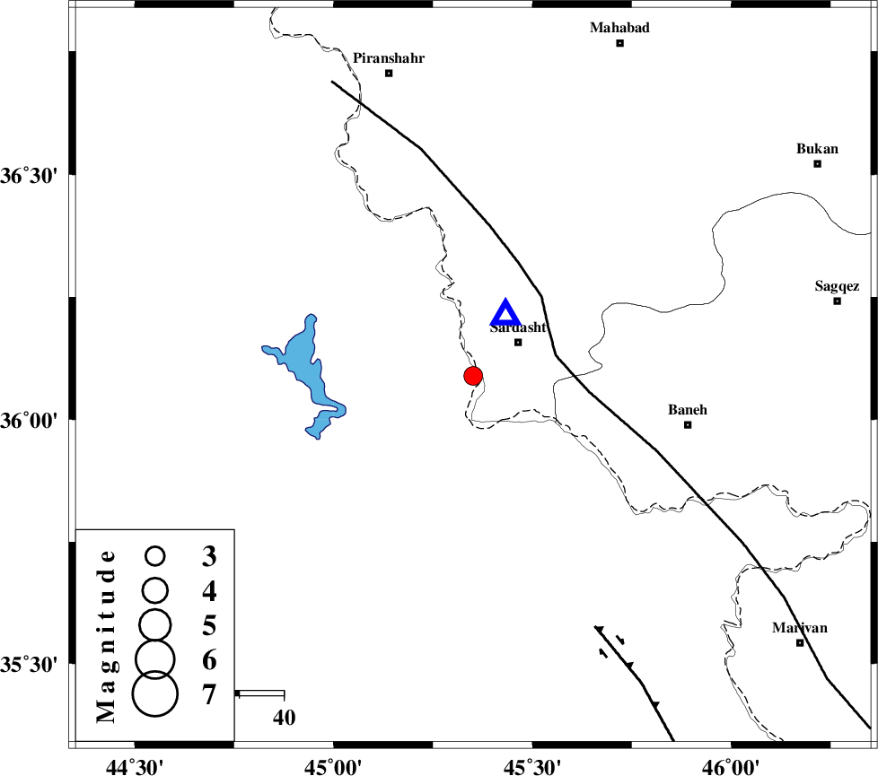
| Date & Time (UTC) | 2021-12-22 08:07:49.6 |
| Date & Time (Local) | 1400/10/1 11:37:49.6 |
| Location | Lat:36.089 Lon: 45.351 |
| Region | Iraq, 13 km -West of Sardasht |
Nearest Cities |
|
| 10 km of Bivaran-e sofla, Azarbaijan Gharbi Province | |
| 13 km West of Sardasht, Azarbaijan Gharbi Province | |
| 18 km West of Bersiv, Azarbaijan Gharbi Province | |
| 22 km South West of Rabat, Azarbaijan Gharbi Province | |
| 23 km South West of Felas, Azarbaijan Gharbi Province | |
| Depth | 12 km |
| Agency | |
Faults within 150 km: |
|
| PIRANSHAHR_F (Length: 253 km) , Distance to epicenter: 19 km | |
| HZF4 (Length: 492 km) , Distance to epicenter: 63 km | |
| Number of Phases | 6 |
| RMS | 0.5 |
| Number of Stations | 6 |
| Error in Latitude | >7.6 km |
| Error in Longitude | 7.6 km |
| Error in Depth | 19.4 km |
Download waveform in seisan format
to download seisan software Click here
to access information about IIEES stations Click here
Amplitude | ||||||||
| UID | Agency | Station | Component | Amplitude | Period | Arrival Time | Proccessing Time | Signal Clip |
| 167552 | IIEES SC | MAHB | Z | 1 | 1 | 2021-12-22 08:08:03 | 2021-12-22 09:00:00 | n |
| 167553 | IIEES SC | ILBA | Z | 0.07 | 1 | 2021-12-22 08:08:33 | 2021-12-22 09:00:00 | n |
| 167554 | IIEES SC | MRD | Z | 0.1 | 1 | 2021-12-22 08:08:33 | 2021-12-22 09:00:00 | n |
Phase | ||||||||||||
| Agency | Station | Component | Phase Type | Phase Quality | First Motion | Observed Arrival Time | Time Residual | Loc. Flag | Input Weight | Distance | Azimuth | |
| IIEES SC | MAHB | Z | EPg | E | 2021-12-22 08:08:03 | -0.8 | y | 0 | 82 | 23 | ||
| IIEES SC | AZR | Z | EPg | E | 2021-12-22 08:08:20 | 0.7 | y | 0 | 185 | 18 | ||
| IIEES SC | SNGE | Z | EPn | E | 2021-12-22 08:08:23 | -0.1 | y | 0 | 212 | 121 | ||
| IIEES SC | ILBA | Z | EPn | E | 2021-12-22 08:08:33 | 0.3 | y | 0 | 284 | 164 | ||
| IIEES SC | MRD | Z | EPn | E | 2021-12-22 08:08:33 | -0.6 | y | 0 | 293 | 6 | ||
| IIEES SC | GRMI | Z | EPn | E | 2021-12-22 08:08:44 | 0.3 | y | 0 | 376 | 37 | ||
کلیه حقوق مادی و معنوی این سایت متعلق به پژوهشگاه بین المللی زلزله شناسی و مهندسی زلزله می باشد.
