خانه / مشخصات زلزله
Magnitude |
:3.8 |
| Date & Time (UTC) | 2021-12-29 07:24:23.1 |
| Date & Time (Local) | 1400/10/8 10:54:23.1 |
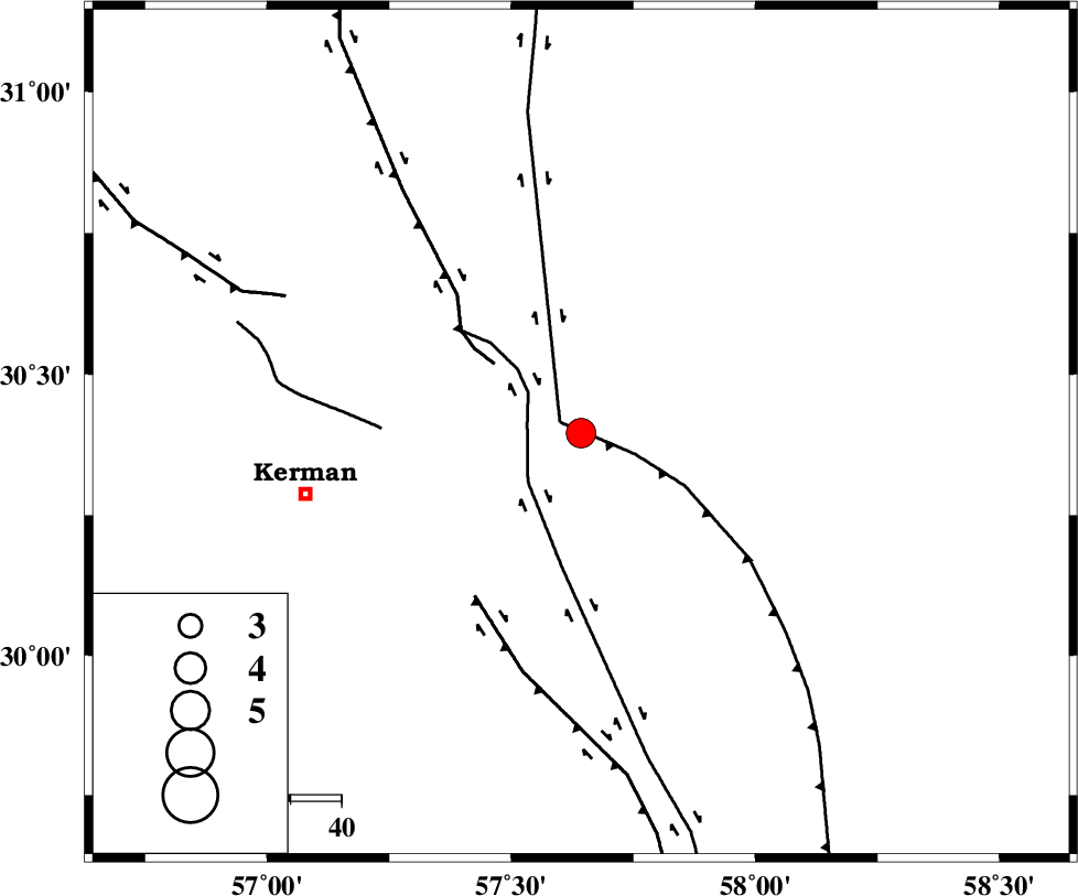
| Location | Lat:30.396 Lon: 57.643 |
| Region | Kerman Province, 55 km North-East of Kerman |
Nearest Cities |
|
| 6 km of Shahdad, Kerman Province | |
| 20 km West of Estehkam, Kerman Province | |
| 24 km North of Sirch, Kerman Province | |
| 32 km North of Jushan, Kerman Province | |
| 37 km South East of Dehlulu, Kerman Province | |
| Depth | 12 km |
| Agency | |
Faults within 150 km: |
|
| SHAHDAD_F (Length: 108 km) , Distance to epicenter: 5 km | |
| NAYBAND_F (Length: 258 km) , Distance to epicenter: 5 km | |
| GOLBAF_SIRCH_F (Length: 114 km) , Distance to epicenter: 11 km | |
| Number of Phases | 7 |
| RMS | 0.5 |
| Number of Stations | 7 |
| Error in Latitude | >4 km |
| Error in Longitude | 4 km |
| Error in Depth | 21.4 km |
Download waveform in seisan format
to download seisan software Click here
to access information about IIEES stations Click here
Amplitude | ||||||||
| UID | Agency | Station | Component | Amplitude | Period | Arrival Time | Proccessing Time | Signal Clip |
| 167831 | IIEES SC | KRBR | Z | 4 | 1 | 2021-12-29 07:24:39 | 2022-01-01 07:35:00 | n |
| 167832 | IIEES SC | BSRN | Z | 2 | 1 | 2021-12-29 07:24:59 | 2022-01-01 07:35:00 | n |
| 167833 | IIEES SC | TABS | Z | 0.3 | 1 | 2021-12-29 07:25:16 | 2022-01-01 07:35:00 | n |
Phase | ||||||||||||
| Agency | Station | Component | Phase Type | Phase Quality | First Motion | Observed Arrival Time | Time Residual | Loc. Flag | Input Weight | Distance | Azimuth | |
| IIEES SC | KRBR | Z | EPg | E | 2021-12-29 07:24:39 | 0 | y | 0 | 96 | 242 | ||
| IIEES SC | BSRN | Z | EPn | E | 2021-12-29 07:24:59 | 0.9 | y | 0 | 224 | 39 | ||
| IIEES SC | ZHSF | Z | EPn | E | 2021-12-29 07:25:09 | -0.5 | y | 0 | 314 | 106 | ||
| IIEES SC | BNDS | Z | EPn | E | 2021-12-29 07:25:17 | 0.9 | y | 0 | 362 | 203 | ||
| IIEES SC | TABS | Z | EPn | E | 2021-12-29 07:25:16 | 0.1 | y | 0 | 364 | 352 | ||
| IIEES SC | YZKH | Z | EPn | E | 2021-12-29 07:25:16 | -0.4 | y | 0 | 365 | 307 | ||
| IIEES SC | SHRT | Z | EPn | E | 2021-12-29 07:25:26 | 0.6 | y | 0 | 439 | 35 | ||
کلیه حقوق مادی و معنوی این سایت متعلق به پژوهشگاه بین المللی زلزله شناسی و مهندسی زلزله می باشد.
