خانه / مشخصات زلزله
Magnitude |
:3 |
| Date & Time (UTC) | 2022-01-23 16:09:19.2 |
| Date & Time (Local) | 1400/11/3 19:39:19.2 |
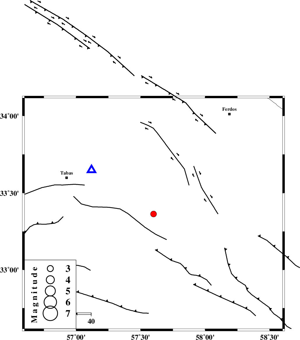
| Location | Lat:33.364 Lon: 57.6 |
| Region | Yazd Province, 68 km South-East of Tabas |
Nearest Cities |
|
| 13 km North East of Dihuk, Yazd Province | |
| 34 km North of Arababad, Yazd Province | |
| 42 km South East of Arsak, Khorasan(center) Province | |
| 58 km South East of Boshravieh, Khorasan(center) Province | |
| 60 km South East of Reqqeh, Khorasan(center) Province | |
| Depth | 10 km |
| Agency | |
Faults within 150 km: |
|
| ESFARDIAR_F (Length: 94 km) , Distance to epicenter: 15 km | |
| TABAS_F2 (Length: 67 km) , Distance to epicenter: 30 km | |
| TABAS_F1 (Length: 91 km) , Distance to epicenter: 30 km | |
| Number of Phases | 9 |
| RMS | 0.4 |
| Number of Stations | 9 |
| Error in Latitude | >1.3 km |
| Error in Longitude | 1.3 km |
| Error in Depth | 2.8 km |
Download waveform in seisan format
to download seisan software Click here
to access information about IIEES stations Click here
Amplitude | ||||||||
| UID | Agency | Station | Component | Amplitude | Period | Arrival Time | Proccessing Time | Signal Clip |
| 168499 | IIEES SC | BSRN | Z | 0.2 | 1 | 2022-01-23 16:09:53 | 2022-01-24 06:24:00 | n |
| 168500 | IIEES SC | YZKH | Z | 0.2 | 1 | 2022-01-23 16:10:05 | 2022-01-24 06:24:00 | n |
| 168501 | IIEES SC | SHRO | Z | 0.05 | 1 | 2022-01-23 16:10:08 | 2022-01-24 06:24:00 | n |
Phase | ||||||||||||
| Agency | Station | Component | Phase Type | Phase Quality | First Motion | Observed Arrival Time | Time Residual | Loc. Flag | Input Weight | Distance | Azimuth | |
| IIEES SC | TABS | Z | EPg | E | 2022-01-23 16:09:28 | -0.6 | y | 0 | 55 | 305 | ||
| IIEES SC | BSRN | Z | EPn | E | 2022-01-23 16:09:53 | -0.3 | y | 0 | 211 | 137 | ||
| IIEES SC | SHRT | Z | EPn | E | 2022-01-23 16:09:58 | -0.2 | y | 0 | 252 | 83 | ||
| IIEES SC | YZKH | Z | EPn | E | 2022-01-23 16:10:05 | 0.5 | y | 0 | 302 | 249 | ||
| IIEES SC | SHRO | Z | EPn | E | 2022-01-23 16:10:08 | 0.1 | y | 0 | 327 | 334 | ||
| IIEES SC | TBJM | Z | EPn | E | 2022-01-23 16:10:08 | 0.5 | y | 0 | 328 | 50 | ||
| IIEES SC | KRBR | Z | EPn | E | 2022-01-23 16:10:26 | 11.3 | n | 4 | 383 | 192 | ||
| IIEES SC | ANJ | Z | EPn | E | 2022-01-23 16:10:30 | 11.6 | n | 4 | 411 | 305 | ||
| IIEES SC | KAGH | Z | EPn | E | 2022-01-23 16:10:34 | 11.1 | n | 4 | 451 | 28 | ||
کلیه حقوق مادی و معنوی این سایت متعلق به پژوهشگاه بین المللی زلزله شناسی و مهندسی زلزله می باشد.
