خانه / مشخصات زلزله
Magnitude |
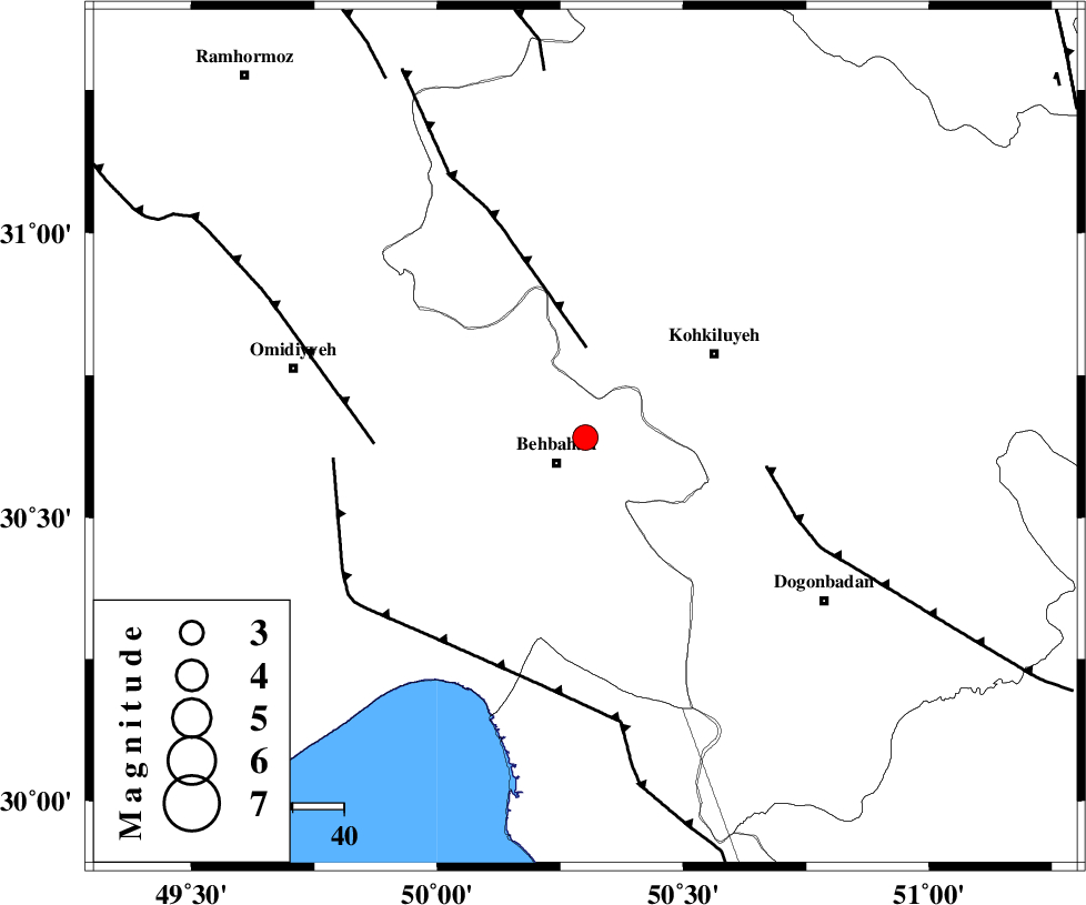
:3.3 |
| Date & Time (UTC) | 2022-02-20 11:48:06.8 |
| Date & Time (Local) | 1400/12/1 15:18:06.8 |
| Location | Lat:30.641 Lon: 50.301 |
| Region | Khoozestan Province, 7 km of Behbahan |
Nearest Cities |
|
| 1 km North of Mansuriyeh, Khoozestan Province | |
| 7 km North of Behbahan, Khoozestan Province | |
| 14 km East of Dodange-ye bozorg, Khoozestan Province | |
| 30 km South West of Dehdasht, Kohkiluieh va boyerahmad Province | |
| 37 km North of Sardasht, Khoozestan Province | |
| Depth | 12 km |
| Agency | |
Faults within 150 km: |
|
| MFF4 (Length: 62 km) , Distance to epicenter: 18 km | |
| MISHAN_F (Length: 76 km) , Distance to epicenter: 36 km | |
| AGHAJARI_F (Length: 88 km) , Distance to epicenter: 41 km | |
| Number of Phases | 8 |
| RMS | 0.2 |
| Number of Stations | 8 |
| Error in Latitude | >1.3 km |
| Error in Longitude | 1.3 km |
| Error in Depth | 8.9 km |
Download waveform in seisan format
to download seisan software Click here
to access information about IIEES stations Click here
Amplitude | ||||||||
| UID | Agency | Station | Component | Amplitude | Period | Arrival Time | Proccessing Time | Signal Clip |
| 169064 | IIEES SC | KLNJ | Z | 2 | 1 | 2022-02-20 11:48:28 | 2022-02-27 08:42:00 | n |
| 169065 | IIEES SC | ASAO | Z | 0.05 | 1 | 2022-02-20 11:49:09 | 2022-02-27 08:42:00 | n |
| 169066 | IIEES SC | YZKH | Z | 0.05 | 1 | 2022-02-20 11:49:11 | 2022-02-27 08:42:00 | n |
| 169067 | IIEES SC | SNGE | Z | 0.03 | 1 | 2022-02-20 11:49:24 | 2022-02-27 08:42:00 | n |
Phase | ||||||||||||
| Agency | Station | Component | Phase Type | Phase Quality | First Motion | Observed Arrival Time | Time Residual | Loc. Flag | Input Weight | Distance | Azimuth | |
| IIEES SC | KLNJ | Z | EPg | E | 2022-02-20 11:48:28 | -0.1 | y | 0 | 130 | 72 | ||
| IIEES SC | AHRM | Z | EPn | E | 2022-02-20 11:48:41 | 0.1 | y | 0 | 213 | 158 | ||
| IIEES SC | NASN | Z | EPn | E | 2022-02-20 11:48:57 | 0.1 | y | 0 | 337 | 45 | ||
| IIEES SC | GHIR | Z | EPn | E | 2022-02-20 11:48:59 | -0.8 | y | 0 | 369 | 135 | ||
| IIEES SC | ASAO | Z | EPn | E | 2022-02-20 11:49:09 | 0.2 | y | 0 | 434 | 357 | ||
| IIEES SC | YZKH | Z | EPn | E | 2022-02-20 11:49:11 | 0 | y | 0 | 451 | 65 | ||
| IIEES SC | ILBA | Z | EPn | E | 2022-02-20 11:49:17 | -0.1 | y | 0 | 508 | 311 | ||
| IIEES SC | SNGE | Z | EPn | E | 2022-02-20 11:49:24 | -0.3 | y | 0 | 566 | 331 | ||
کلیه حقوق مادی و معنوی این سایت متعلق به پژوهشگاه بین المللی زلزله شناسی و مهندسی زلزله می باشد.
