خانه / مشخصات زلزله
Magnitude |
:3.4 |
| Date & Time (UTC) | 2020-08-31 17:57:57.3 |
| Date & Time (Local) | 1399/6/10 22:27:57.3 |
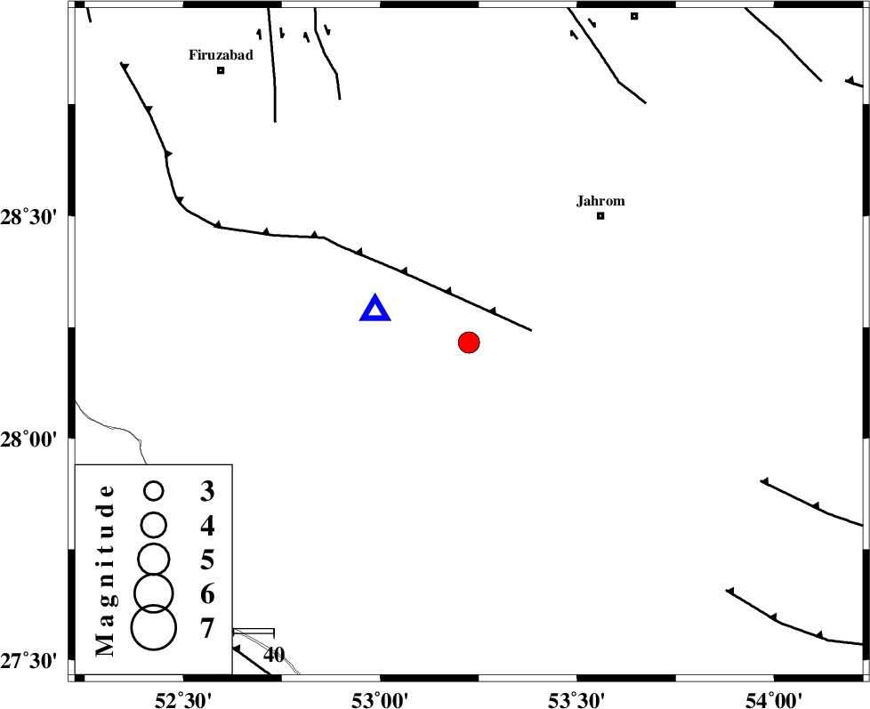
| Location | Lat:28.216 Lon: 53.225 |
| Region | Fars Province, 34 km South-East of Qir va Karzin |
Nearest Cities |
|
| 10 km North of Seyfabad, Fars Province | |
| 19 km South of Mobarakabad, Fars Province | |
| 26 km South East of Shahrak-e jonubi, Fars Province | |
| 31 km South of Fathabad, Fars Province | |
| 33 km South West of Hasanabad, Fars Province | |
| Depth | 8 km |
| Agency | |
Faults within 150 km: |
|
| QIR_F (Length: 130 km) , Distance to epicenter: 16 km | |
| SABZ_PUSHAN_F_Z2 (Length: 24 km) , Distance to epicenter: 68 km | |
| SABZ_PUSHAN_F_Z1 (Length: 69 km) , Distance to epicenter: 73 km | |
| Number of Phases | 6 |
| RMS | 0.4 |
| Number of Stations | 6 |
| Error in Latitude | >10.5 km |
| Error in Longitude | 10.5 km |
| Error in Depth | 9.1 km |
Download waveform in seisan format
to download seisan software Click here
to access information about IIEES stations Click here
Amplitude | ||||||||
| UID | Agency | Station | Component | Amplitude | Period | Arrival Time | Proccessing Time | Signal Clip |
| 193863 | IIEES SC | KRBR | Z | 0.1 | 1 | 2020-08-31 17:58:55 | 2024-06-30 05:58:00 | n |
| 193864 | IIEES SC | YZKH | Z | 0.05 | 1 | 2020-08-31 17:59:06 | 2024-06-30 05:58:00 | n |
| 193865 | IIEES SC | NASN | Z | 0.04 | 1 | 2020-08-31 17:59:08 | 2024-06-30 05:58:00 | n |
Phase | ||||||||||||
| Agency | Station | Component | Phase Type | Phase Quality | First Motion | Observed Arrival Time | Time Residual | Loc. Flag | Input Weight | Distance | Azimuth | |
| IIEES SC | GHIR | Z | EPg | E | 2020-08-31 17:58:01 | -0.3 | y | 0 | 25 | 288 | ||
| IIEES SC | AHRM | Z | EPn | E | 2020-08-31 17:58:30 | 0.3 | y | 0 | 202 | 291 | ||
| IIEES SC | KRBR | Z | EPn | E | 2020-08-31 17:58:55 | -0.1 | y | 0 | 396 | 60 | ||
| IIEES SC | YZKH | Z | EPn | E | 2020-08-31 17:59:06 | 0.7 | y | 0 | 481 | 16 | ||
| IIEES SC | NASN | Z | EPn | E | 2020-08-31 17:59:08 | -0.5 | y | 0 | 510 | 355 | ||
| IIEES SC | GTMR | Z | EPn | E | 2020-08-31 17:59:12 | -9.2 | n | 4 | 616 | 320 | ||
کلیه حقوق مادی و معنوی این سایت متعلق به پژوهشگاه بین المللی زلزله شناسی و مهندسی زلزله می باشد.
