خانه / مشخصات زلزله
Magnitude |
:2.7 |
| Date & Time (UTC) | 2014-03-11 20:44:10.5 |
| Date & Time (Local) | 1392/12/21 00:14:10.5 |
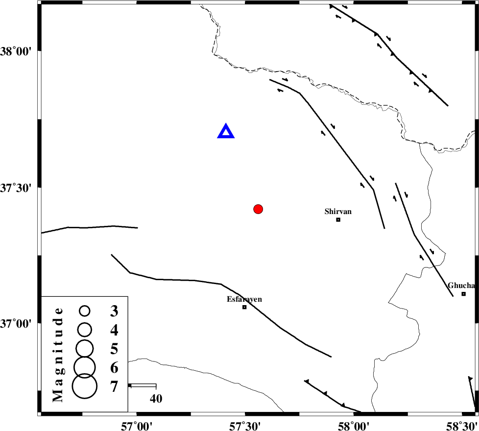
| Location | Lat:37.42 Lon: 57.56 |
| Region | Khorasan(north) Province, 21 km East of Bojnurd |
Nearest Cities |
|
| 13 km of Hesar-egarmkhanh, Khorasan(north) Province | |
| 19 km North West of Zavarom, Khorasan(north) Province | |
| 21 km East of Bojnurd, Khorasan(north) Province | |
| 21 km East of Void, Khorasan(north) Province | |
| 30 km West of Ziyarat, Khorasan(north) Province | |
| Depth | 15 km |
| Agency | |
Faults within 150 km: |
|
| ESFARAYEN_F (Length: 111 km) , Distance to epicenter: 34 km | |
| BAGHAN_GERMAB_F (Length: 79 km) , Distance to epicenter: 42 km | |
| ROBATE_QARABIL_F (Length: 168 km) , Distance to epicenter: 50 km | |
| Number of Phases | 3 |
| RMS | 0 |
| Number of Stations | 3 |
| Error in Latitude | >1.5 km |
| Error in Longitude | 3.4 km |
| Error in Depth | 0 km |
Download waveform in seisan format
to download seisan software Click here
to access information about IIEES stations Click here
Amplitude | ||||||||
| UID | Agency | Station | Component | Amplitude | Period | Arrival Time | Proccessing Time | Signal Clip |
| 91967 | IIEES | BJRD | E | 1476.4 | 0.44 | 2014-03-11 20:44:23 | 2014-03-12 03:08:00 | n |
| 91968 | IIEES | BJRD | N | 646.3 | 0.4 | 2014-03-11 20:44:23 | 2014-03-12 03:08:00 | n |
Phase | ||||||||||||
| Agency | Station | Component | Phase Type | Phase Quality | First Motion | Observed Arrival Time | Time Residual | Loc. Flag | Input Weight | Distance | Azimuth | |
| IIEES | BJRD | Z | Pg | E | 2014-03-11 20:44:17 | 0 | y | 34 | 336 | |||
| IIEES | SHRO | E | Pg | E | 2014-03-11 20:44:44 | 0 | y | 209 | 222 | |||
| IIEES | SHRT | Z | Pn | E | 2014-03-11 20:45:18 | 0 | y | 486 | 149 | |||
کلیه حقوق مادی و معنوی این سایت متعلق به پژوهشگاه بین المللی زلزله شناسی و مهندسی زلزله می باشد.
