خانه / مشخصات زلزله
Magnitude |
:2.2 |
| Date & Time (UTC) | 2014-11-28 02:19:29.7 |
| Date & Time (Local) | 1393/9/7 05:49:29.7 |
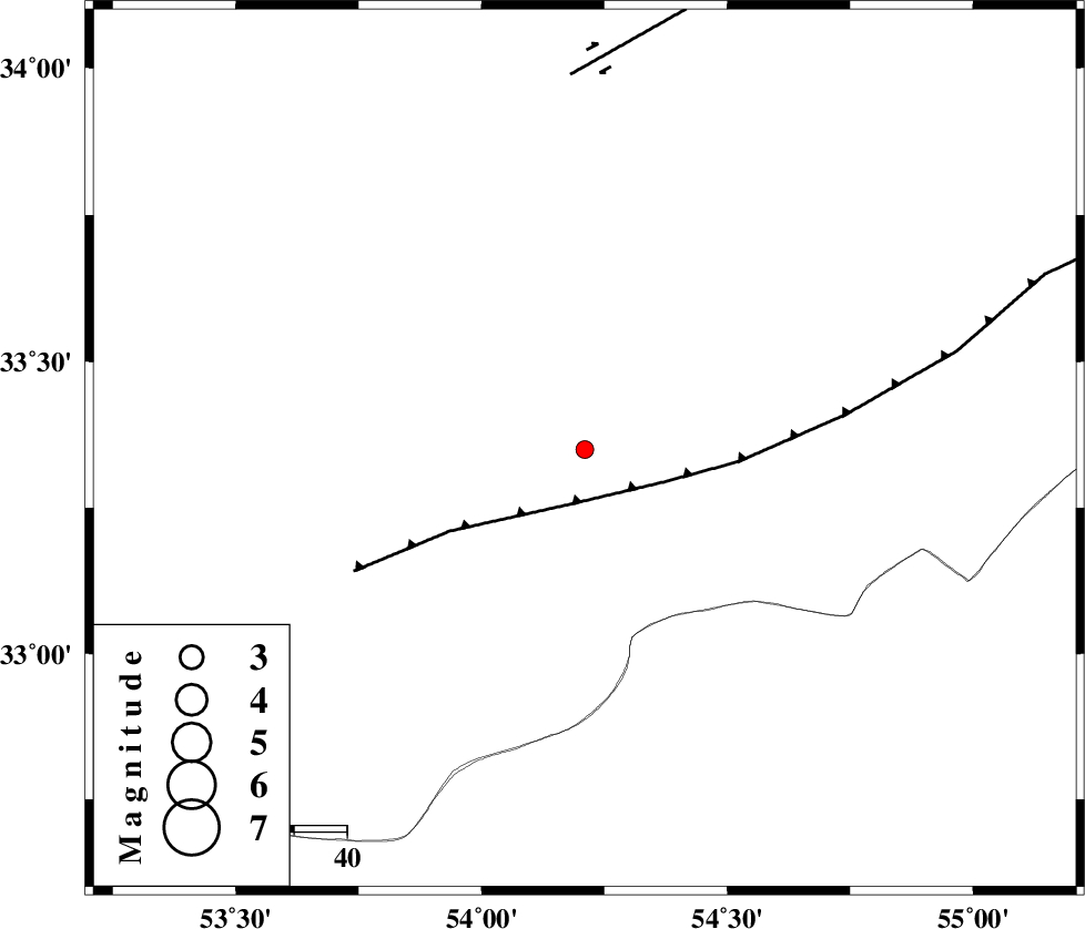
| Location | Lat:33.35 Lon: 54.21 |
| Region | Esfahan Province, 117 km North-East of Ardakan |
Nearest Cities |
|
| 34 km South West of Chupanan, Esfahan Province | |
| 48 km North East of Anarak, Esfahan Province | |
| 71 km North West of Hajiabad, Yazd Province | |
| 77 km North West of Zarrin, Yazd Province | |
| 79 km South West of Jondaq, Esfahan Province | |
| Depth | 43 km |
| Agency | |
Faults within 150 km: |
|
| BIABANAK_F (Length: 162 km) , Distance to epicenter: 10 km | |
| DORUNEH_F (Length: 713 km) , Distance to epicenter: 71 km | |
| CHAH_ZANGUL_F (Length: 123 km) , Distance to epicenter: 107 km | |
| Number of Phases | 7 |
| RMS | 0.3 |
| Number of Stations | 4 |
| Error in Latitude | >3.8 km |
| Error in Longitude | 3.5 km |
| Error in Depth | 5.4 km |
Download waveform in seisan format
to download seisan software Click here
to access information about IIEES stations Click here
Amplitude | ||||||||
| UID | Agency | Station | Component | Amplitude | Period | Arrival Time | Proccessing Time | Signal Clip |
| 94399 | IIEES | YZKH | E | 54.9 | 0.24 | 2014-11-28 02:20:05 | 2014-11-29 01:34:00 | n |
| 94400 | IIEES | TABS | N | 10.6 | 0.44 | 2014-11-28 02:20:59 | 2014-11-29 01:34:00 | n |
Phase | ||||||||||||
| Agency | Station | Component | Phase Type | Phase Quality | First Motion | Observed Arrival Time | Time Residual | Loc. Flag | Input Weight | Distance | Azimuth | |
| IIEES | YZKH | Z | Pn | E | 2014-11-28 02:19:48 | -0.57 | y | 112 | 162 | |||
| IIEES | YZKH | E | Sg | E | 2014-11-28 02:20:03 | 0.08 | y | 112 | 162 | |||
| IIEES | NASN | Z | Pn | E | 2014-11-28 02:19:53 | 0.32 | y | 145 | 245 | |||
| IIEES | NASN | E | Sg | E | 2014-11-28 02:20:11 | 0.1 | y | 145 | 245 | |||
| IIEES | TABS | Z | Pn | E | 2014-11-28 02:20:08 | 0.22 | y | 272 | 82 | |||
| IIEES | GHVR | Z | Pn | E | 2014-11-28 02:20:12 | 0.11 | y | 302 | 295 | |||
| IIEES | GHVR | N | Sg | E | 2014-11-28 02:20:52 | -0.28 | y | 302 | 295 | |||
کلیه حقوق مادی و معنوی این سایت متعلق به پژوهشگاه بین المللی زلزله شناسی و مهندسی زلزله می باشد.
