خانه / مشخصات زلزله
Magnitude |
:2.2 |
| Date & Time (UTC) | 2014-12-24 10:31:57.0 |
| Date & Time (Local) | 1393/10/3 14:01:57.0 |
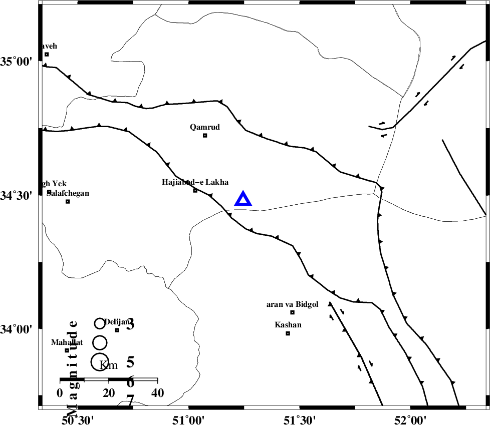
| Location | Lat:34.46 Lon: 51.34 |
| Region | Qom Province, 46 km North-West of Aran va bidgol |
Nearest Cities |
|
| 29 km East of Hajiabad-e lakha, Qom Province | |
| 33 km North of Mashgan, Esfahan Province | |
| 37 km North of Nasrabad, Esfahan Province | |
| 38 km South East of Qamrud, Qom Province | |
| 39 km North East of Yahyaabad, Esfahan Province | |
| Depth | 6 km |
| Agency | |
Faults within 150 km: |
|
| KASHAN_F (Length: 44 km) , Distance to epicenter: 34 km | |
| KUSHK_E_NOSRAT_F (Length: 230 km) , Distance to epicenter: 41 km | |
| SIAHKUH_F (Length: 154 km) , Distance to epicenter: 65 km | |
| Number of Phases | 6 |
| RMS | 0.1 |
| Number of Stations | 5 |
| Error in Latitude | >2.3 km |
| Error in Longitude | 2.1 km |
| Error in Depth | 4.3 km |
Download waveform in seisan format
to download seisan software Click here
to access information about IIEES stations Click here
Amplitude | ||||||||
| UID | Agency | Station | Component | Amplitude | Period | Arrival Time | Proccessing Time | Signal Clip |
| 94590 | IIEES | DAMV | E | 45.6 | 0.48 | 2014-12-24 10:32:41 | 2014-12-24 07:50:00 | n |
Phase | ||||||||||||
| Agency | Station | Component | Phase Type | Phase Quality | First Motion | Observed Arrival Time | Time Residual | Loc. Flag | Input Weight | Distance | Azimuth | |
| IIEES | GHVR | Z | Pg | E | 2014-12-24 10:31:58 | -0.16 | y | 8.58 | 287 | |||
| IIEES | ASAO | Z | Pg | E | 2014-12-24 10:32:18 | 0.01 | y | 121 | 275 | |||
| IIEES | ASAO | N | Sg | E | 2014-12-24 10:32:33 | 0.08 | y | 121 | 275 | |||
| IIEES | DAMV | Z | Pg | E | 2014-12-24 10:32:21 | 0.1 | y | 142 | 24 | |||
| IIEES | KHMZ | Z | Pg | E | 2014-12-24 10:32:22 | 0.02 | y | 149 | 238 | |||
| IIEES | CHTH | Z | Pg | E | 2014-12-24 10:32:25 | -0.05 | y | 162 | 353 | |||
کلیه حقوق مادی و معنوی این سایت متعلق به پژوهشگاه بین المللی زلزله شناسی و مهندسی زلزله می باشد.
