خانه / مشخصات زلزله
Magnitude |
:2.7 |
| Date & Time (UTC) | 2015-02-23 14:13:12.0 |
| Date & Time (Local) | 1393/12/4 17:43:12.0 |
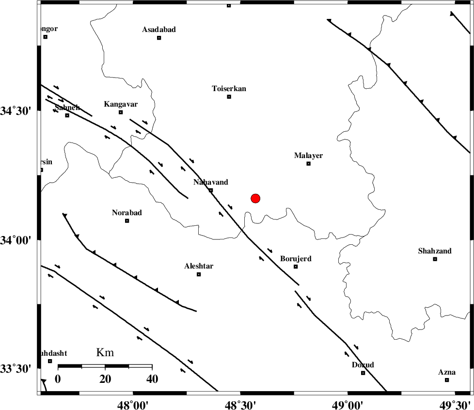
| Location | Lat:34.16 Lon: 48.57 |
| Region | Hamedan Province, 20 km East of Nahavand |
Nearest Cities |
|
| 5 km North of Anuj, Hamedan Province | |
| 8 km North of Kahakdan, Hamedan Province | |
| 11 km North of Jaefarabad, Lorestan Province | |
| 13 km of Avarzman, Hamedan Province | |
| 13 km West of Saman, Hamedan Province | |
| Depth | 14 km |
| Agency | |
Faults within 150 km: |
|
| NAHAVAND_F (Length: 102 km) , Distance to epicenter: 15 km | |
| SAHANEH_F (Length: 77 km) , Distance to epicenter: 29 km | |
| DORUD (Length: 100 km) , Distance to epicenter: 43 km | |
| Number of Phases | 4 |
| RMS | 0 |
| Number of Stations | 3 |
| Error in Latitude | >4.7 km |
| Error in Longitude | 6.5 km |
| Error in Depth | 4.7 km |
Download waveform in seisan format
to download seisan software Click here
to access information about IIEES stations Click here
Amplitude | ||||||||
| UID | Agency | Station | Component | Amplitude | Period | Arrival Time | Proccessing Time | Signal Clip |
| 95083 | IIEES | GHVR | N | 56.9 | 0.4 | 2015-02-23 14:14:23 | 2015-02-23 02:41:00 | n |
| 95084 | IIEES | GHVR | E | 43.9 | 0.44 | 2015-02-23 14:14:23 | 2015-02-23 02:41:00 | n |
Phase | ||||||||||||
| Agency | Station | Component | Phase Type | Phase Quality | First Motion | Observed Arrival Time | Time Residual | Loc. Flag | Input Weight | Distance | Azimuth | |
| IIEES | KHMZ | Z | Pg | E | 2015-02-23 14:13:34 | -0.02 | y | 137 | 109 | |||
| IIEES | KHMZ | Z | Sg | E | 2015-02-23 14:13:51 | 0.01 | y | 137 | 109 | |||
| IIEES | ASAO | Z | Pg | E | 2015-02-23 14:13:35 | -0.02 | y | 141 | 72 | |||
| IIEES | GHVR | Z | Pn | E | 2015-02-23 14:13:50 | 0.04 | y | 249 | 81 | |||
کلیه حقوق مادی و معنوی این سایت متعلق به پژوهشگاه بین المللی زلزله شناسی و مهندسی زلزله می باشد.
