خانه / مشخصات زلزله
Magnitude |
:2.6 |
| Date & Time (UTC) | 2015-10-03 15:26:18.2 |
| Date & Time (Local) | 1394/7/11 18:56:18.2 |
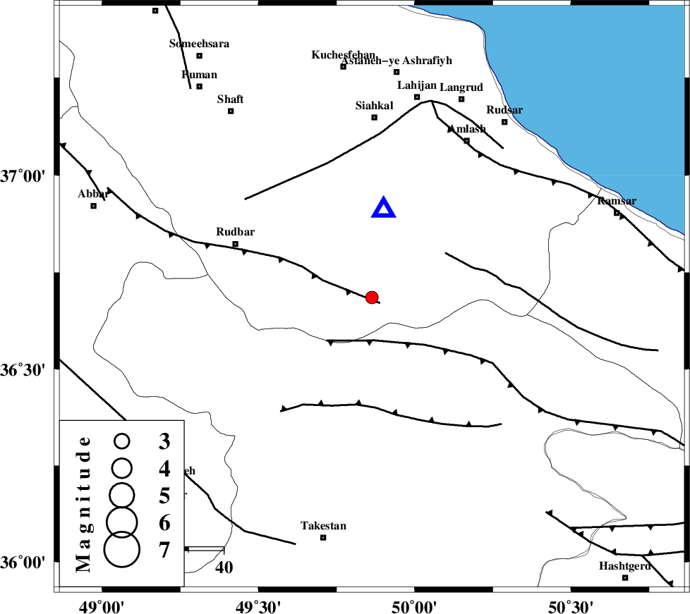
| Location | Lat:36.685 Lon: 49.863 |
| Region | Gilan Province, 52 km South of Siahkal |
Nearest Cities |
|
| 7 km of Jirhandeh, Gilan Province | |
| 12 km West of Kelishom, Gilan Province | |
| 19 km South of Barresar, Gilan Province | |
| 26 km South East of Dashtvil, Gilan Province | |
| 31 km North East of Kuhgir-e sofla, Ghazvin Province | |
| Depth | 14 km |
| Agency | |
Faults within 150 km: |
|
| RUDBAR_F (Length: 93 km) , Distance to epicenter: 3 km | |
| ALAMUTRUD_F (Length: 140 km) , Distance to epicenter: 12 km | |
| BONAN_F (Length: 74 km) , Distance to epicenter: 25 km | |
| Number of Phases | 7 |
| RMS | 0.4 |
| Number of Stations | 6 |
| Error in Latitude | >6 km |
| Error in Longitude | 5.9 km |
| Error in Depth | 9.8 km |
Download waveform in seisan format
to download seisan software Click here
to access information about IIEES stations Click here
Amplitude | ||||||||
| UID | Agency | Station | Component | Amplitude | Period | Arrival Time | Proccessing Time | Signal Clip |
| 101383 | IIEES | THKV | N | 99.2 | 0.12 | 2015-10-03 15:26:54 | 2015-10-04 06:26:00 | n |
| 101384 | IIEES | ASAO | N | 61.9 | 0.31 | 2015-10-03 15:27:27 | 2015-10-04 06:26:00 | n |
| 101385 | IIEES | ASAO | E | 48.8 | 0.35 | 2015-10-03 15:27:29 | 2015-10-04 06:26:00 | n |
| 101386 | IIEES | GHVR | E | 17.7 | 0.24 | 2015-10-03 15:27:41 | 2015-10-04 06:26:00 | n |
Phase | ||||||||||||
| Agency | Station | Component | Phase Type | Phase Quality | First Motion | Observed Arrival Time | Time Residual | Loc. Flag | Input Weight | Distance | Azimuth | |
| IIEES | ZNJK | Z | Pg | E | 2015-10-03 15:26:36 | -0.13 | y | 105 | 269 | |||
| IIEES | THKV | Z | Pg | E | 2015-10-03 15:26:38 | -0.97 | y | 125 | 133 | |||
| IIEES | CHTH | Z | Pg | E | 2015-10-03 15:26:42 | 0.12 | y | 143 | 127 | |||
| IIEES | DAMV | Z | Pg | E | 2015-10-03 15:26:55 | 0.47 | y | 223 | 121 | |||
| IIEES | ASAO | Z | Pn | E | 2015-10-03 15:26:55 | 0.33 | y | 238 | 176 | |||
| IIEES | ASAO | E | Sg | E | 2015-10-03 15:27:25 | -0.04 | y | 238 | 176 | |||
| IIEES | GHVR | Z | Pn | E | 2015-10-03 15:27:00 | 0.23 | y | 275 | 152 | |||
کلیه حقوق مادی و معنوی این سایت متعلق به پژوهشگاه بین المللی زلزله شناسی و مهندسی زلزله می باشد.
