سبد خرید خالی است.
خانه / مشخصات زلزله
Magnitude |
:2.6 |
| Date & Time (UTC) | 2017-04-16 09:27:28.1 |
| Date & Time (Local) | 1396/1/27 13:57:28.1 |
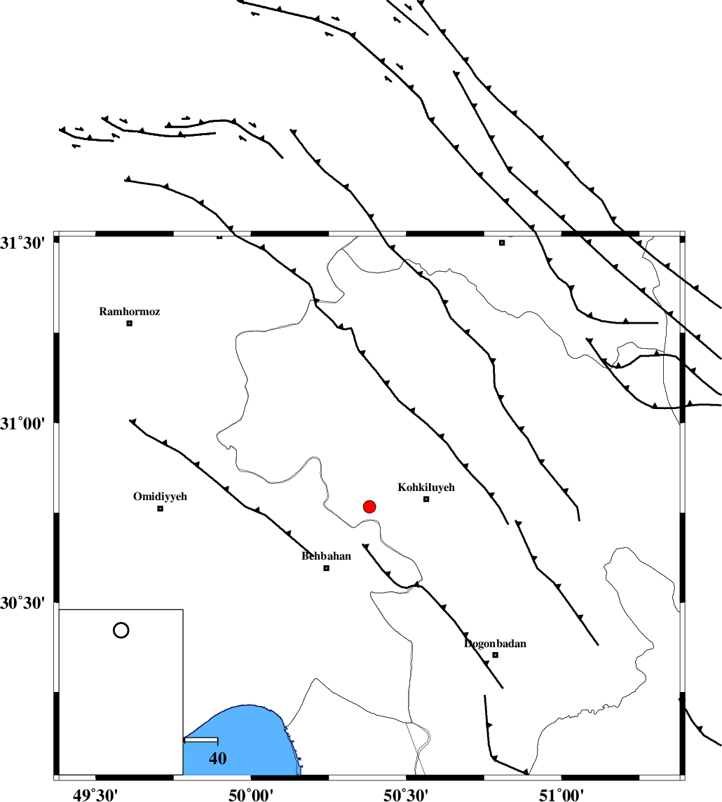
| Location | Lat:30.767 Lon: 50.381 |
| Region | Kohkiluieh va boyerahmad Province, 18 km -West of Dehdasht |
Nearest Cities |
|
| 17 km North of Mansuriyeh, Khoozestan Province | |
| 18 km West of Dehdasht, Kohkiluieh va boyerahmad Province | |
| 20 km North East of Dodange-ye bozorg, Khoozestan Province | |
| 23 km North East of Behbahan, Khoozestan Province | |
| 24 km South of Lendeh, Kohkiluieh va boyerahmad Province | |
| Depth | 15 km |
| Agency | |
Faults within 150 km: |
|
| MFF4 (Length: 62 km) , Distance to epicenter: 8 km | |
| MISHAN_F (Length: 76 km) , Distance to epicenter: 34 km | |
| AGHAJARI_F (Length: 88 km) , Distance to epicenter: 51 km | |
| Number of Phases | 7 |
| RMS | 0.3 |
| Number of Stations | 7 |
| Error in Latitude | >2.9 km |
| Error in Longitude | 3 km |
| Error in Depth | 0 km |
Download waveform in seisan format
to download seisan software Click here
to access information about IIEES stations Click here
Amplitude | ||||||||
| UID | Agency | Station | Component | Amplitude | Period | Arrival Time | Proccessing Time | Signal Clip |
| 115044 | IIEES | AHRM | E | 38 | 0.41 | 2017-04-16 09:28:37 | 2017-04-16 10:04:00 | n |
| 115045 | IIEES | AHRM | N | 30.2 | 0.2 | 2017-04-16 09:28:38 | 2017-04-16 10:04:00 | n |
| 115046 | IIEES | KHMZ | E | 9 | 0.36 | 2017-04-16 09:29:13 | 2017-04-16 10:04:00 | n |
| 115047 | IIEES | GHIR | E | 10 | 0.54 | 2017-04-16 09:29:05 | 2017-04-16 10:04:00 | n |
| 115048 | IIEES | GHIR | N | 16.4 | 0.27 | 2017-04-16 09:29:07 | 2017-04-16 10:04:00 | n |
| 115049 | IIEES | SNGE | E | 3.3 | 0.39 | 2017-04-16 09:29:41 | 2017-04-16 10:04:00 | n |
| 115050 | IIEES | SNGE | N | 3 | 0.31 | 2017-04-16 09:29:44 | 2017-04-16 10:04:00 | n |
Phase | ||||||||||||
| Agency | Station | Component | Phase Type | Phase Quality | First Motion | Observed Arrival Time | Time Residual | Loc. Flag | Input Weight | Distance | Azimuth | |
| IIEES | AHRM | Z | Pn | E | 2017-04-16 09:28:04 | 0.3 | y | 229 | 157 | |||
| IIEES | NASN | Z | Pn | E | 2017-04-16 09:28:16 | 0.37 | y | 322 | 45 | |||
| IIEES | KHMZ | Z | Pn | E | 2017-04-16 09:28:16 | -0.27 | y | 332 | 353 | |||
| IIEES | GHIR | Z | Pn | E | 2017-04-16 09:28:21 | -0.45 | y | 373 | 137 | |||
| IIEES | ASAO | Z | Pn | E | 2017-04-16 09:28:28 | -0.08 | y | 421 | 356 | |||
| IIEES | YZKH | Z | Pn | E | 2017-04-16 09:28:30 | -0.1 | y | 438 | 65 | |||
| IIEES | SNGE | Z | Pn | E | 2017-04-16 09:28:45 | 0.2 | y | 557 | 330 | |||
کلیه حقوق مادی و معنوی این سایت متعلق به پژوهشگاه بین المللی زلزله شناسی و مهندسی زلزله می باشد.
