خانه / مشخصات زلزله
Magnitude |
:2.6 |
| Date & Time (UTC) | 2017-06-12 01:56:23.4 |
| Date & Time (Local) | 1396/3/22 06:26:23.4 |
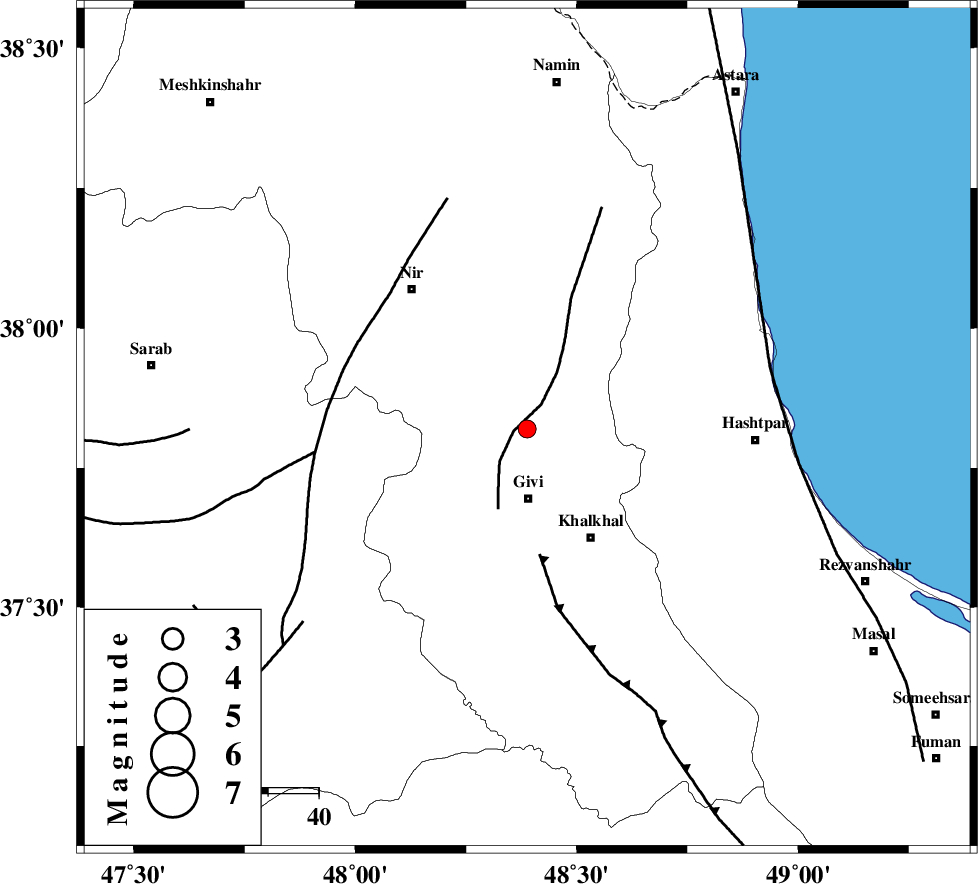
| Location | Lat:37.82 Lon: 48.388 |
| Region | Ardebil Province, 14 km North of Givi |
Nearest Cities |
|
| 14 km North of Givi, Ardebil Province | |
| 16 km North East of Ganjgah, Ardebil Province | |
| 20 km South East of Kuraeim, Ardebil Province | |
| 25 km North West of Khalkhal, Ardebil Province | |
| 26 km South of Budalalu, Ardebil Province | |
| Depth | 15 km |
| Agency | |
Faults within 150 km: |
|
| SANGAVAR_F (Length: 61 km) , Distance to epicenter: 3 km | |
| MASULEL_F (Length: 90 km) , Distance to epicenter: 25 km | |
| BOZQUSH (Length: 70 km) , Distance to epicenter: 38 km | |
| Number of Phases | 5 |
| RMS | 0.2 |
| Number of Stations | 5 |
| Error in Latitude | >3.9 km |
| Error in Longitude | 9.1 km |
| Error in Depth | 9.6 km |
Download waveform in seisan format
to download seisan software Click here
to access information about IIEES stations Click here
Amplitude | ||||||||
| UID | Agency | Station | Component | Amplitude | Period | Arrival Time | Proccessing Time | Signal Clip |
| 116709 | IIEES | GRMI | N | 89.8 | 0.19 | 2017-06-12 01:57:01 | 2017-06-12 07:19:00 | n |
| 116710 | IIEES | GRMI | E | 178.8 | 0.15 | 2017-06-12 01:57:01 | 2017-06-12 07:19:00 | n |
| 116711 | IIEES | GIDE | N | 70.6 | 0.25 | 2017-06-12 01:57:13 | 2017-06-12 07:19:00 | n |
| 116712 | IIEES | GIDE | E | 68.7 | 0.5 | 2017-06-12 01:57:18 | 2017-06-12 07:19:00 | n |
Phase | ||||||||||||
| Agency | Station | Component | Phase Type | Phase Quality | First Motion | Observed Arrival Time | Time Residual | Loc. Flag | Input Weight | Distance | Azimuth | |
| IIEES | GRMI | Z | Pg | E | 2017-06-12 01:56:43 | -0.24 | y | 118 | 339 | |||
| IIEES | ZNJK | Z | Pg | E | 2017-06-12 01:56:45 | -0.27 | y | 130 | 168 | |||
| IIEES | GIDE | Z | Pg | E | 2017-06-12 01:56:51 | 0.21 | y | 168 | 126 | |||
| IIEES | SNGE | Z | Pn | E | 2017-06-12 01:57:10 | 0.06 | y | 317 | 197 | |||
| IIEES | MAKU | Z | Pn | E | 2017-06-12 01:57:16 | 0.3 | y | 365 | 299 | |||
کلیه حقوق مادی و معنوی این سایت متعلق به پژوهشگاه بین المللی زلزله شناسی و مهندسی زلزله می باشد.
