خانه / مشخصات زلزله
Magnitude |
:2.7 |
| Date & Time (UTC) | 2017-11-14 21:13:41.4 |
| Date & Time (Local) | 1396/8/24 00:43:41.4 |
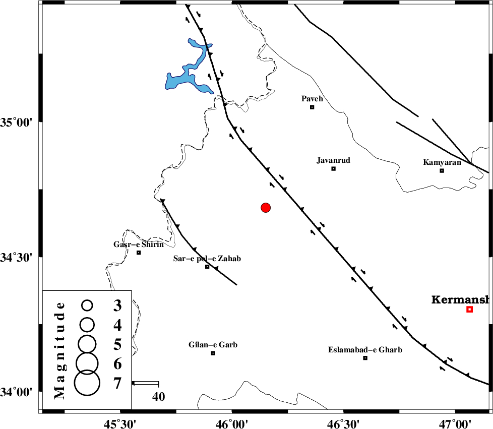
| Location | Lat:34.682 Lon: 46.151 |
| Region | Kermanshah Province, 30 km -East of Tazehabad |
Nearest Cities |
|
| 5 km of Qolqoleh, Kermanshah Province | |
| 14 km West of Mirabad, Kermanshah Province | |
| 21 km South West of Shervineh, Kermanshah Province | |
| 22 km North East of Bazmirabad, Kermanshah Province | |
| 25 km South East of Dehsheykh, Kermanshah Province | |
| Depth | 15 km |
| Agency | |
Faults within 150 km: |
|
| HZF4 (Length: 492 km) , Distance to epicenter: 11 km | |
| MFF8 (Length: 48 km) , Distance to epicenter: 33 km | |
| SARTAKHT_F (Length: 78 km) , Distance to epicenter: 64 km | |
| Number of Phases | 7 |
| RMS | 0.4 |
| Number of Stations | 5 |
| Error in Latitude | >4.9 km |
| Error in Longitude | 9.1 km |
| Error in Depth | 9.4 km |
Download waveform in seisan format
to download seisan software Click here
to access information about IIEES stations Click here
Amplitude | ||||||||
| UID | Agency | Station | Component | Amplitude | Period | Arrival Time | Proccessing Time | Signal Clip |
| 121864 | IIEES | ILBA | N | 182.6 | 0.61 | 2017-11-14 21:14:21 | 2017-11-18 07:31:00 | n |
| 121865 | IIEES | SNGE | N | 255.9 | 0.49 | 2017-11-14 21:14:18 | 2017-11-18 07:31:00 | n |
| 121866 | IIEES | SNGE | E | 244.3 | 0.44 | 2017-11-14 21:14:22 | 2017-11-18 07:31:00 | n |
| 121867 | IIEES | ASAO | E | 15.1 | 0.34 | 2017-11-14 21:15:31 | 2017-11-18 07:31:00 | n |
| 121868 | IIEES | ASAO | N | 10.2 | 0.68 | 2017-11-14 21:15:37 | 2017-11-18 07:31:00 | n |
Phase | ||||||||||||
| Agency | Station | Component | Phase Type | Phase Quality | First Motion | Observed Arrival Time | Time Residual | Loc. Flag | Input Weight | Distance | Azimuth | |
| IIEES | ILBA | Z | Pg | E | 2017-11-14 21:14:00 | -0.13 | y | 117 | 177 | |||
| IIEES | ILBA | N | Sg | E | 2017-11-14 21:14:15 | -0.23 | y | 117 | 177 | |||
| IIEES | SNGE | Z | Pg | E | 2017-11-14 21:14:01 | -0.15 | y | 118 | 67 | |||
| IIEES | SNGE | N | Sg | E | 2017-11-14 21:14:15 | -0.37 | y | 118 | 67 | |||
| IIEES | ASAO | Z | Pn | E | 2017-11-14 21:14:33 | 0.25 | y | 356 | 91 | |||
| IIEES | KHMZ | Z | Pn | E | 2017-11-14 21:14:35 | 0.94 | y | 367 | 105 | |||
| IIEES | GRMI | Z | Pn | E | 2017-11-14 21:14:49 | -0.15 | y | 484 | 18 | |||
کلیه حقوق مادی و معنوی این سایت متعلق به پژوهشگاه بین المللی زلزله شناسی و مهندسی زلزله می باشد.
