خانه / مشخصات زلزله
Magnitude |
:2.8 |
| Date & Time (UTC) | 2018-01-23 08:02:46.8 |
| Date & Time (Local) | 1396/11/3 11:32:46.8 |
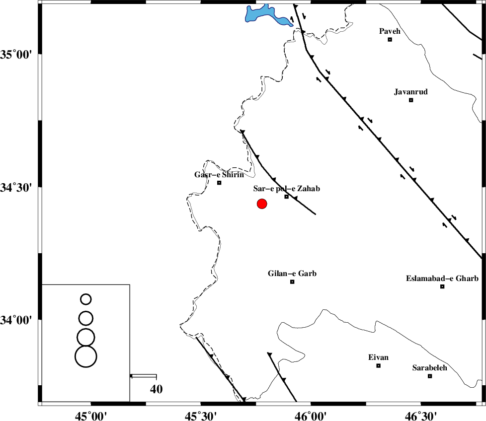
| Location | Lat:34.437 Lon: 45.777 |
| Region | Kermanshah Province, 11 km -West of Sar-e pol-e zahab |
Nearest Cities |
|
| 5 km of Qareh belagh, Kermanshah Province | |
| 11 km West of Sar-e pol-e zahab, Kermanshah Province | |
| 14 km North West of Tarkveys, Kermanshah Province | |
| 14 km South of Mirmiru, Kermanshah Province | |
| 15 km North of Chub baghan, Kermanshah Province | |
| Depth | 6 km |
| Agency | |
Faults within 150 km: |
|
| MFF8 (Length: 48 km) , Distance to epicenter: 11 km | |
| HZF4 (Length: 492 km) , Distance to epicenter: 54 km | |
| MFF7 (Length: 99 km) , Distance to epicenter: 62 km | |
| Number of Phases | 7 |
| RMS | 0.3 |
| Number of Stations | 6 |
| Error in Latitude | >2.6 km |
| Error in Longitude | 6.9 km |
| Error in Depth | 7.1 km |
Download waveform in seisan format
to download seisan software Click here
to access information about IIEES stations Click here
Amplitude | ||||||||
| UID | Agency | Station | Component | Amplitude | Period | Arrival Time | Proccessing Time | Signal Clip |
| 127413 | IIEES | SNGE | E | 65.5 | 0.42 | 2018-01-23 08:03:39 | 2018-01-24 06:13:00 | n |
| 127414 | IIEES | SNGE | N | 70 | 0.35 | 2018-01-23 08:03:42 | 2018-01-24 06:13:00 | n |
| 127415 | IIEES | SRSL | E | 127.7 | 0.31 | 2018-01-23 08:03:48 | 2018-01-24 06:13:00 | n |
| 127416 | IIEES | SRSL | N | 286.7 | 0.52 | 2018-01-23 08:03:49 | 2018-01-24 06:13:00 | n |
Phase | ||||||||||||
| Agency | Station | Component | Phase Type | Phase Quality | First Motion | Observed Arrival Time | Time Residual | Loc. Flag | Input Weight | Distance | Azimuth | |
| IIEES | ILBA | Z | Pg | E | 2018-01-23 08:03:03 | -0.3 | y | 98.5 | 156 | |||
| IIEES | ILBA | E | Sg | E | 2018-01-23 08:03:16 | 0.26 | y | 98.5 | 156 | |||
| IIEES | SNGE | Z | Pg | E | 2018-01-23 08:03:14 | -0.01 | y | 161 | 63 | |||
| IIEES | SRSL | Z | Pn | E | 2018-01-23 08:03:20 | 0.11 | y | 199 | 351 | |||
| IIEES | ZNJK | Z | Pn | E | 2018-01-23 08:03:40 | 0.4 | y | 362 | 46 | |||
| IIEES | ASAO | Z | Pn | E | 2018-01-23 08:03:43 | -0.3 | y | 390 | 87 | |||
| IIEES | GRMI | Z | Pn | E | 2018-01-23 08:03:59 | -0.23 | y | 521 | 21 | |||
کلیه حقوق مادی و معنوی این سایت متعلق به پژوهشگاه بین المللی زلزله شناسی و مهندسی زلزله می باشد.
