خانه / مشخصات زلزله
Magnitude |
:2.8 |
| Date & Time (UTC) | 2018-02-17 03:21:20.5 |
| Date & Time (Local) | 1396/11/28 06:51:20.5 |
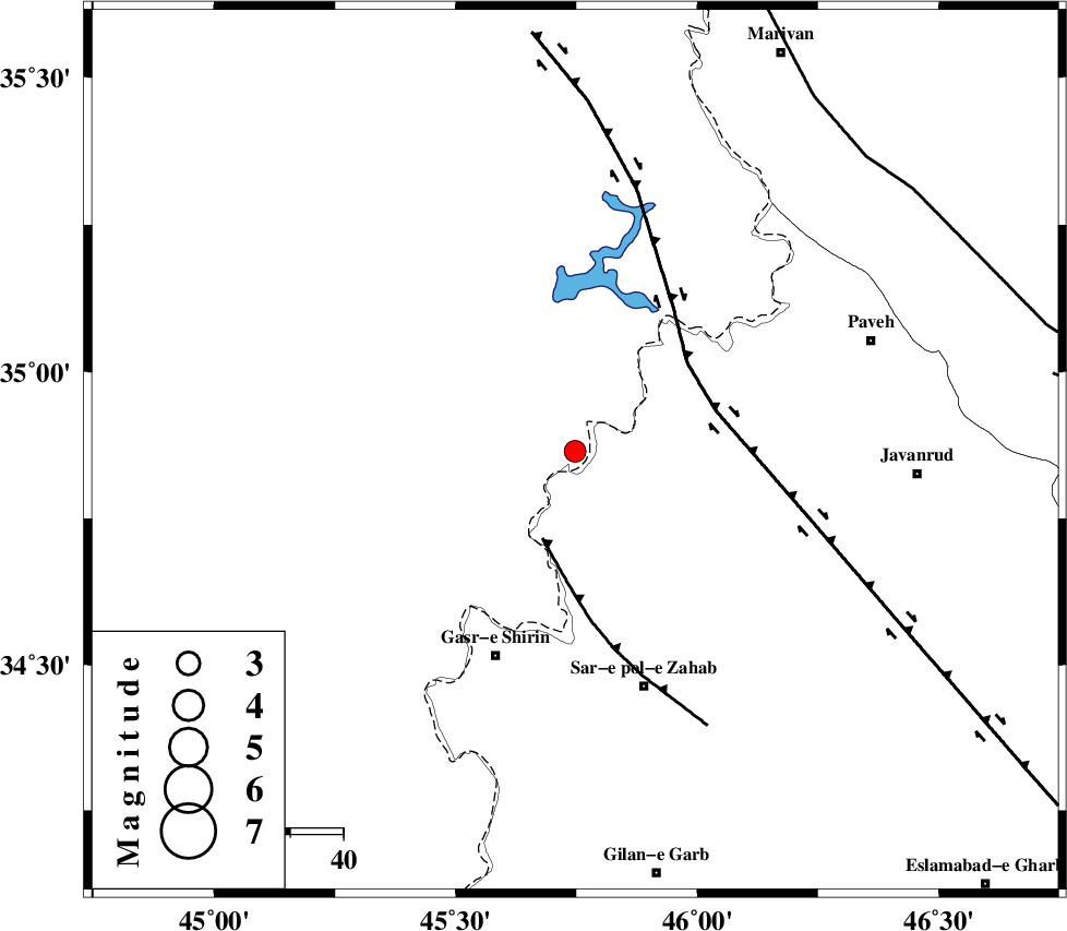
| Location | Lat:34.865 Lon: 45.747 |
| Region | Iraq, 14 km North of Tazehabad |
Nearest Cities |
|
| 12 km North of Tappeh rash, Kermanshah Province | |
| 14 km North of Tazehabad, Kermanshah Province | |
| 18 km North of Gardehnu, Kermanshah Province | |
| 21 km North West of Dehsheykh, Kermanshah Province | |
| 29 km South West of Markhil, Kermanshah Province | |
| Depth | 14 km |
| Agency | |
Faults within 150 km: |
|
| MFF8 (Length: 48 km) , Distance to epicenter: 18 km | |
| HZF4 (Length: 492 km) , Distance to epicenter: 27 km | |
| PIRANSHAHR_F (Length: 253 km) , Distance to epicenter: 78 km | |
| Number of Phases | 4 |
| RMS | 0.1 |
| Number of Stations | 4 |
| Error in Latitude | >1.9 km |
| Error in Longitude | 3.9 km |
| Error in Depth | 5.4 km |
Download waveform in seisan format
to download seisan software Click here
to access information about IIEES stations Click here
Amplitude | ||||||||
| UID | Agency | Station | Component | Amplitude | Period | Arrival Time | Proccessing Time | Signal Clip |
| 128680 | IIEES | ILBA | E | 218.2 | 0.29 | 2018-02-17 03:22:06 | 2018-02-18 06:38:00 | n |
| 128681 | IIEES | ILBA | N | 125.5 | 0.51 | 2018-02-17 03:22:09 | 2018-02-18 06:38:00 | n |
Phase | ||||||||||||
| Agency | Station | Component | Phase Type | Phase Quality | First Motion | Observed Arrival Time | Time Residual | Loc. Flag | Input Weight | Distance | Azimuth | |
| IIEES | ILBA | Z | Pg | E | 2018-02-17 03:21:44 | -0.03 | y | 144 | 163 | |||
| IIEES | SNGE | Z | Pg | E | 2018-02-17 03:21:45 | -0.1 | y | 148 | 80 | |||
| IIEES | SRSL | Z | Pg | E | 2018-02-17 03:21:45 | -0.01 | y | 152 | 349 | |||
| IIEES | ASAO | Z | Pn | E | 2018-02-17 03:22:17 | 0.17 | y | 394 | 94 | |||
کلیه حقوق مادی و معنوی این سایت متعلق به پژوهشگاه بین المللی زلزله شناسی و مهندسی زلزله می باشد.
