خانه / مشخصات زلزله
Magnitude |
:3.2 |
| Date & Time (UTC) | 2018-05-31 23:52:30.8 |
| Date & Time (Local) | 1397/3/11 04:22:30.8 |
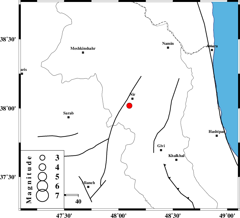
| Location | Lat:38.018 Lon: 48.099 |
| Region | Ardebil Province, 6 km of Nir |
Nearest Cities |
|
| 6 km North of Qarehshiran, Ardebil Province | |
| 6 km of Nir, Ardebil Province | |
| 11 km of Rezaqoli qeshlaq, Ardebil Province | |
| 14 km South of Eslamabad, Ardebil Province | |
| 15 km North West of Kuraeim, Ardebil Province | |
| Depth | 15 km |
| Agency | |
Faults within 150 km: |
|
| BOZQUSH (Length: 70 km) , Distance to epicenter: 9 km | |
| SANGAVAR_F (Length: 61 km) , Distance to epicenter: 32 km | |
| MASULEL_F (Length: 90 km) , Distance to epicenter: 55 km | |
| Number of Phases | 9 |
| RMS | 0.3 |
| Number of Stations | 9 |
| Error in Latitude | >6.1 km |
| Error in Longitude | 5.5 km |
| Error in Depth | 7.2 km |
Download waveform in seisan format
to download seisan software Click here
to access information about IIEES stations Click here
Amplitude | ||||||||
| UID | Agency | Station | Component | Amplitude | Period | Arrival Time | Proccessing Time | Signal Clip |
| 133015 | IIEES | ZNJK | E | 181 | 0.52 | 2018-05-31 23:53:23 | 2018-06-02 05:44:00 | n |
| 133016 | IIEES | GIDE | E | 281.1 | 0.53 | 2018-05-31 23:53:37 | 2018-06-02 05:44:00 | n |
| 133017 | IIEES | GIDE | N | 315.2 | 0.79 | 2018-05-31 23:53:37 | 2018-06-02 05:44:00 | n |
Phase | ||||||||||||
| Agency | Station | Component | Phase Type | Phase Quality | First Motion | Observed Arrival Time | Time Residual | Loc. Flag | Input Weight | Distance | Azimuth | |
| IIEES | ZNJK | Z | Pg | E | 2018-05-31 23:52:56 | -0.59 | y | 158 | 161 | |||
| IIEES | GIDE | Z | Pn | E | 2018-05-31 23:53:03 | -0.19 | y | 201 | 127 | |||
| IIEES | SRSL | Z | Pn | E | 2018-05-31 23:53:17 | 0.22 | y | 310 | 231 | |||
| IIEES | SNGE | Z | Pn | E | 2018-05-31 23:53:19 | 0.1 | y | 331 | 192 | |||
| IIEES | MAKU | Z | Pn | E | 2018-05-31 23:53:19 | -0.23 | y | 332 | 298 | |||
| IIEES | CHTH | Z | Pn | E | 2018-05-31 23:53:23 | 0.54 | y | 357 | 130 | |||
| IIEES | ASAO | Z | Pn | E | 2018-05-31 23:53:31 | 0.15 | y | 422 | 155 | |||
| IIEES | KHMZ | Z | Pn | E | 2018-05-31 23:53:41 | 0.08 | y | 504 | 160 | |||
| IIEES | ILBA | Z | Pn | E | 2018-05-31 23:53:42 | 0.1 | y | 516 | 200 | |||
کلیه حقوق مادی و معنوی این سایت متعلق به پژوهشگاه بین المللی زلزله شناسی و مهندسی زلزله می باشد.
