خانه / مشخصات زلزله
Magnitude |
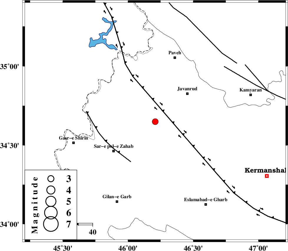
:2.9 |
| Date & Time (UTC) | 2018-09-17 21:06:36.3 |
| Date & Time (Local) | 1397/6/27 01:36:36.3 |
| Location | Lat:34.65 Lon: 46.209 |
| Region | Kermanshah Province, 30 km South-West of Javanrud |
Nearest Cities |
|
| 9 km of Qolqoleh, Kermanshah Province | |
| 10 km of Mirabad, Kermanshah Province | |
| 19 km North West of Zavleh olia, Kermanshah Province | |
| 22 km South of Shervineh, Kermanshah Province | |
| 24 km West of Dolatabad, Kermanshah Province | |
| Depth | 6 km |
| Agency | |
Faults within 150 km: |
|
| HZF4 (Length: 492 km) , Distance to epicenter: 12 km | |
| MFF8 (Length: 48 km) , Distance to epicenter: 33 km | |
| SARTAKHT_F (Length: 78 km) , Distance to epicenter: 62 km | |
| Number of Phases | 7 |
| RMS | 0.3 |
| Number of Stations | 7 |
| Error in Latitude | >3.3 km |
| Error in Longitude | 6.3 km |
| Error in Depth | 6.7 km |
Download waveform in seisan format
to download seisan software Click here
to access information about IIEES stations Click here
Amplitude | ||||||||
| UID | Agency | Station | Component | Amplitude | Period | Arrival Time | Proccessing Time | Signal Clip |
| 136889 | IIEES | ILBA | N | 287.3 | 0.32 | 2018-09-17 21:07:17 | 2018-09-18 07:58:00 | n |
| 136890 | IIEES | ILBA | E | 311.8 | 0.39 | 2018-09-17 21:07:19 | 2018-09-18 07:58:00 | n |
| 136891 | IIEES | SRSL | N | 217.7 | 0.28 | 2018-09-17 21:07:38 | 2018-09-18 07:58:00 | n |
| 136892 | IIEES | SRSL | E | 163.9 | 0.4 | 2018-09-17 21:07:42 | 2018-09-18 07:58:00 | n |
| 136893 | IIEES | ASAO | N | 12.6 | 0.72 | 2018-09-17 21:08:27 | 2018-09-18 07:58:00 | n |
| 136894 | IIEES | KHMZ | N | 22.5 | 0.84 | 2018-09-17 21:08:33 | 2018-09-18 07:58:00 | n |
Phase | ||||||||||||
| Agency | Station | Component | Phase Type | Phase Quality | First Motion | Observed Arrival Time | Time Residual | Loc. Flag | Input Weight | Distance | Azimuth | |
| IIEES | ILBA | Z | Pg | E | 2018-09-17 21:06:55 | -0.24 | y | 114 | 180 | |||
| IIEES | SNGE | Z | Pg | E | 2018-09-17 21:06:55 | -0.56 | y | 115 | 64 | |||
| IIEES | SRSL | Z | Pg | E | 2018-09-17 21:07:08 | 0.02 | y | 187 | 338 | |||
| IIEES | ZNJK | Z | Pn | E | 2018-09-17 21:07:24 | -0.11 | y | 317 | 44 | |||
| IIEES | ASAO | Z | Pn | E | 2018-09-17 21:07:29 | 0.43 | y | 350 | 91 | |||
| IIEES | KHMZ | Z | Pn | E | 2018-09-17 21:07:30 | 0.42 | y | 360 | 105 | |||
| IIEES | GRMI | Z | Pn | E | 2018-09-17 21:07:45 | 0.22 | y | 485 | 18 | |||
کلیه حقوق مادی و معنوی این سایت متعلق به پژوهشگاه بین المللی زلزله شناسی و مهندسی زلزله می باشد.
