خانه / مشخصات زلزله
Magnitude |
:2.7 |
| Date & Time (UTC) | 2018-10-01 06:16:30.0 |
| Date & Time (Local) | 1397/7/9 09:46:30.0 |
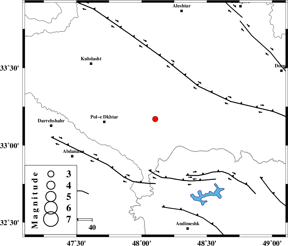
| Location | Lat:33.17 Lon: 48.104 |
| Region | Lorestan Province, 36 km -East of Pol-e dokhtar |
Nearest Cities |
|
| 26 km South East of Maeulan, Lorestan Province | |
| 27 km South of Shoorab-e sofla, Lorestan Province | |
| 32 km South of Godar-e mahmudvand, Lorestan Province | |
| 34 km South West of Daraei, Lorestan Province | |
| 36 km South of Mahmudvand, Lorestan Province | |
| Depth | 14 km |
| Agency | |
Faults within 150 km: |
|
| BALARUD_F_Z3 (Length: 53 km) , Distance to epicenter: 37 km | |
| HZF4 (Length: 492 km) , Distance to epicenter: 39 km | |
| BALARUD_F_Z2 (Length: 58 km) , Distance to epicenter: 46 km | |
| Number of Phases | 6 |
| RMS | 0.4 |
| Number of Stations | 5 |
| Error in Latitude | >6.4 km |
| Error in Longitude | 5.4 km |
| Error in Depth | 9.6 km |
Download waveform in seisan format
to download seisan software Click here
to access information about IIEES stations Click here
Amplitude | ||||||||
| UID | Agency | Station | Component | Amplitude | Period | Arrival Time | Proccessing Time | Signal Clip |
| 137389 | IIEES | ILBA | N | 113.4 | 0.42 | 2018-10-01 06:17:31 | 2018-10-03 07:26:00 | n |
| 137390 | IIEES | ILBA | E | 72 | 0.42 | 2018-10-01 06:17:32 | 2018-10-03 07:26:00 | n |
| 137391 | IIEES | ASAO | E | 33.1 | 0.52 | 2018-10-01 06:17:40 | 2018-10-03 07:26:00 | n |
| 137392 | IIEES | GHVR | E | 16.3 | 0.52 | 2018-10-01 06:18:09 | 2018-10-03 07:26:00 | n |
| 137393 | IIEES | GHVR | N | 15.7 | 0.62 | 2018-10-01 06:18:15 | 2018-10-03 07:26:00 | n |
Phase | ||||||||||||
| Agency | Station | Component | Phase Type | Phase Quality | First Motion | Observed Arrival Time | Time Residual | Loc. Flag | Input Weight | Distance | Azimuth | |
| IIEES | ILBA | Z | Pg | E | 2018-10-01 06:17:00 | -0.26 | y | 183 | 286 | |||
| IIEES | KHMZ | Z | Pg | E | 2018-10-01 06:16:59 | -0.55 | y | 184 | 69 | |||
| IIEES | SNGE | Z | Pn | E | 2018-10-01 06:17:06 | 0.56 | y | 224 | 342 | |||
| IIEES | SNGE | N | Sg | E | 2018-10-01 06:17:33 | -0.18 | y | 224 | 342 | |||
| IIEES | ASAO | Z | Pn | E | 2018-10-01 06:17:06 | -0.08 | y | 235 | 49 | |||
| IIEES | GHVR | Z | Pn | E | 2018-10-01 06:17:18 | 0.57 | y | 325 | 63 | |||
کلیه حقوق مادی و معنوی این سایت متعلق به پژوهشگاه بین المللی زلزله شناسی و مهندسی زلزله می باشد.
