خانه / مشخصات زلزله
Magnitude |
:2.5 |
| Date & Time (UTC) | 2018-10-02 07:31:52.1 |
| Date & Time (Local) | 1397/7/10 11:01:52.1 |
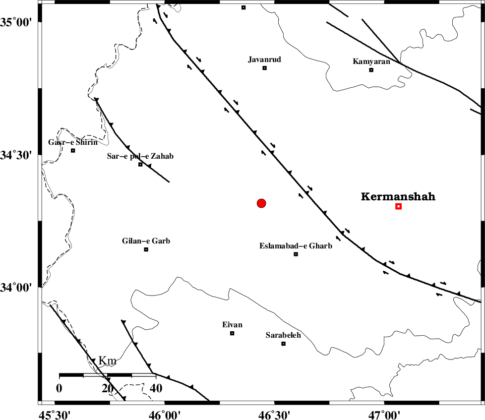
| Location | Lat:34.317 Lon: 46.44 |
| Region | Kermanshah Province, 26 km North-West of Eslam Abad-E-Gharb |
Nearest Cities |
|
| 8 km of Gahvareh, Kermanshah Province | |
| 16 km North of Khosroabad, Kermanshah Province | |
| 19 km North East of Kerend, Kermanshah Province | |
| 19 km North East of Telesm, Kermanshah Province | |
| 23 km North West of Hasanabad, Kermanshah Province | |
| Depth | 14 km |
| Agency | |
Faults within 150 km: |
|
| HZF4 (Length: 492 km) , Distance to epicenter: 22 km | |
| MFF8 (Length: 48 km) , Distance to epicenter: 39 km | |
| MFF7 (Length: 99 km) , Distance to epicenter: 76 km | |
| Number of Phases | 7 |
| RMS | 0.3 |
| Number of Stations | 5 |
| Error in Latitude | >2.1 km |
| Error in Longitude | 3.1 km |
| Error in Depth | 5.7 km |
Download waveform in seisan format
to download seisan software Click here
to access information about IIEES stations Click here
Amplitude | ||||||||
| UID | Agency | Station | Component | Amplitude | Period | Arrival Time | Proccessing Time | Signal Clip |
| 137408 | IIEES | ILBA | E | 344 | 0.53 | 2018-10-02 07:32:17 | 2018-10-03 07:26:00 | n |
| 137409 | IIEES | ILBA | N | 226.8 | 0.4 | 2018-10-02 07:32:19 | 2018-10-03 07:26:00 | n |
| 137410 | IIEES | SNGE | N | 54 | 0.31 | 2018-10-02 07:32:31 | 2018-10-03 07:26:00 | n |
Phase | ||||||||||||
| Agency | Station | Component | Phase Type | Phase Quality | First Motion | Observed Arrival Time | Time Residual | Loc. Flag | Input Weight | Distance | Azimuth | |
| IIEES | ILBA | Z | Pg | E | 2018-10-02 07:32:05 | -0.24 | y | 79.7 | 196 | |||
| IIEES | SNGE | Z | Pg | E | 2018-10-02 07:32:12 | -0.15 | y | 120 | 44 | |||
| IIEES | SNGE | N | Sg | E | 2018-10-02 07:32:26 | -0.24 | y | 120 | 44 | |||
| IIEES | SRSL | Z | Pn | E | 2018-10-02 07:32:28 | -0.18 | y | 229 | 337 | |||
| IIEES | SRSL | N | Sg | E | 2018-10-02 07:32:57 | 0.25 | y | 229 | 337 | |||
| IIEES | ASAO | Z | Pn | E | 2018-10-02 07:32:41 | 0.18 | y | 331 | 85 | |||
| IIEES | KHMZ | Z | Pn | E | 2018-10-02 07:32:41 | 0.46 | y | 332 | 100 | |||
کلیه حقوق مادی و معنوی این سایت متعلق به پژوهشگاه بین المللی زلزله شناسی و مهندسی زلزله می باشد.
