خانه / مشخصات زلزله
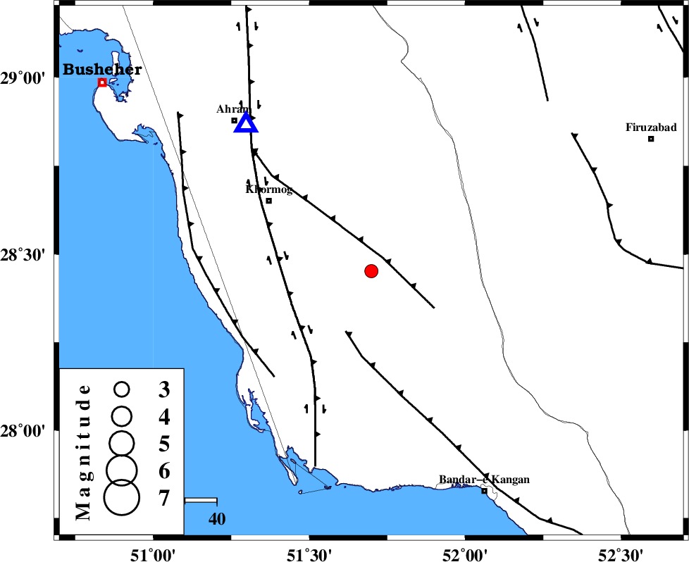
Magnitude |
:2.7 |
| Date & Time (UTC) | 2018-10-03 01:30:06.8 |
| Date & Time (Local) | 1397/7/11 05:00:06.8 |
| Location | Lat:28.452 Lon: 51.699 |
| Region | Bushehr Province, 39 km South-East of Khormog |
Nearest Cities |
|
| 9 km North of Shanbeh, Bushehr Province | |
| 21 km North East of Baduleh, Bushehr Province | |
| 22 km North East of Kaki, Bushehr Province | |
| 36 km South East of Buheyri, Bushehr Province | |
| 36 km North East of Abkesh, Bushehr Province | |
| Depth | 24 km |
| Agency | |
Faults within 150 km: |
|
| MFF5 (Length: 74 km) , Distance to epicenter: 6 km | |
| MFF3 (Length: 292 km) , Distance to epicenter: 21 km | |
| BORAZJAN_F (Length: 168 km) , Distance to epicenter: 27 km | |
| Number of Phases | 6 |
| RMS | 0.2 |
| Number of Stations | 4 |
| Error in Latitude | >9.3 km |
| Error in Longitude | 6.3 km |
| Error in Depth | 5.4 km |
Download waveform in seisan format
to download seisan software Click here
to access information about IIEES stations Click here
Amplitude | ||||||||
| UID | Agency | Station | Component | Amplitude | Period | Arrival Time | Proccessing Time | Signal Clip |
| 137428 | IIEES | GHIR | N | 171.9 | 0.37 | 2018-10-03 01:30:47 | 2018-10-03 07:26:00 | n |
| 137429 | IIEES | GHIR | E | 145.4 | 0.42 | 2018-10-03 01:30:50 | 2018-10-03 07:26:00 | n |
Phase | ||||||||||||
| Agency | Station | Component | Phase Type | Phase Quality | First Motion | Observed Arrival Time | Time Residual | Loc. Flag | Input Weight | Distance | Azimuth | |
| IIEES | AHRM | Z | Pg | E | 2018-10-03 01:30:17 | -0.14 | y | 60.4 | 319 | |||
| IIEES | AHRM | N | Sg | E | 2018-10-03 01:30:25 | 0.09 | y | 60.4 | 319 | |||
| IIEES | GHIR | Z | Pg | E | 2018-10-03 01:30:28 | 0.16 | y | 128 | 98 | |||
| IIEES | GHIR | N | Sg | E | 2018-10-03 01:30:43 | -0.11 | y | 128 | 98 | |||
| IIEES | NASN | Z | Pn | E | 2018-10-03 01:31:14 | -0.24 | y | 494 | 12 | |||
| IIEES | YZKH | Z | Pn | E | 2018-10-03 01:31:18 | 0.25 | y | 518 | 32 | |||
کلیه حقوق مادی و معنوی این سایت متعلق به پژوهشگاه بین المللی زلزله شناسی و مهندسی زلزله می باشد.
