خانه / مشخصات زلزله
Magnitude |
:2.5 |
| Date & Time (UTC) | 2018-10-08 00:01:31.0 |
| Date & Time (Local) | 1397/7/16 03:31:31.0 |
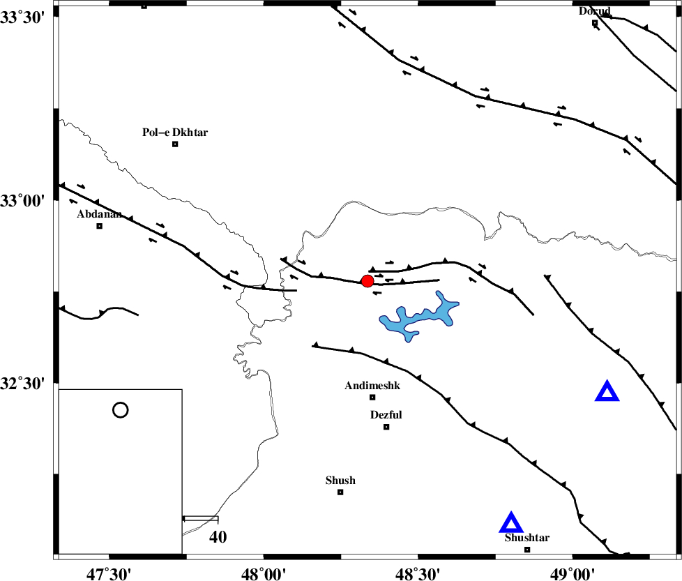
| Location | Lat:32.779 Lon: 48.336 |
| Region | Khoozestan Province, 36 km North of Andimeshk |
Nearest Cities |
|
| 1 km North of Sorkhakan, Khoozestan Province | |
| 10 km North of Bidruyeh, Khoozestan Province | |
| 14 km North of Hoseinieh, Khoozestan Province | |
| 36 km North of Andimeshk, Khoozestan Province | |
| 44 km West of Shuy, Khoozestan Province | |
| Depth | 14 km |
| Agency | |
Faults within 150 km: |
|
| BALARUD_F_Z3 (Length: 53 km) , Distance to epicenter: 2 km | |
| BALARUD_F_Z2 (Length: 58 km) , Distance to epicenter: 3 km | |
| BALARUD_F_Z1 (Length: 87 km) , Distance to epicenter: 22 km | |
| Number of Phases | 7 |
| RMS | 0.2 |
| Number of Stations | 5 |
| Error in Latitude | >7.5 km |
| Error in Longitude | 3.4 km |
| Error in Depth | 6.6 km |
Download waveform in seisan format
to download seisan software Click here
to access information about IIEES stations Click here
Amplitude | ||||||||
| UID | Agency | Station | Component | Amplitude | Period | Arrival Time | Proccessing Time | Signal Clip |
| 137588 | IIEES | ILBA | E | 45 | 0.3 | 2018-10-08 00:02:40 | 2018-10-08 05:47:00 | n |
| 137589 | IIEES | ILBA | N | 46 | 0.64 | 2018-10-08 00:02:41 | 2018-10-08 05:47:00 | n |
| 137590 | IIEES | ASAO | E | 24.7 | 0.58 | 2018-10-08 00:02:47 | 2018-10-08 05:47:00 | n |
| 137591 | IIEES | SNGE | E | 10.6 | 0.76 | 2018-10-08 00:02:55 | 2018-10-08 05:47:00 | n |
| 137592 | IIEES | GHVR | E | 12.9 | 0.51 | 2018-10-08 00:03:13 | 2018-10-08 05:47:00 | n |
| 137593 | IIEES | GHVR | N | 7.8 | 0.36 | 2018-10-08 00:03:16 | 2018-10-08 05:47:00 | n |
Phase | ||||||||||||
| Agency | Station | Component | Phase Type | Phase Quality | First Motion | Observed Arrival Time | Time Residual | Loc. Flag | Input Weight | Distance | Azimuth | |
| IIEES | KHMZ | Z | Pg | E | 2018-10-08 00:02:01 | -0.03 | y | 185 | 54 | |||
| IIEES | KHMZ | N | Sg | E | 2018-10-08 00:02:23 | -0.16 | y | 185 | 54 | |||
| IIEES | ILBA | Z | Pn | E | 2018-10-08 00:02:05 | -0.22 | y | 220 | 296 | |||
| IIEES | ILBA | N | S | E | 2018-10-08 00:02:31 | -0.04 | y | 220 | 296 | |||
| IIEES | ASAO | Z | Pn | E | 2018-10-08 00:02:10 | -0.05 | y | 251 | 38 | |||
| IIEES | SNGE | Z | Pn | E | 2018-10-08 00:02:13 | 0.29 | y | 272 | 341 | |||
| IIEES | GHVR | Z | Pn | E | 2018-10-08 00:02:19 | 0.25 | y | 329 | 54 | |||
کلیه حقوق مادی و معنوی این سایت متعلق به پژوهشگاه بین المللی زلزله شناسی و مهندسی زلزله می باشد.
