خانه / مشخصات زلزله
Magnitude |
:2.9 |
| Date & Time (UTC) | 2018-10-10 17:20:10.4 |
| Date & Time (Local) | 1397/7/18 20:50:10.4 |
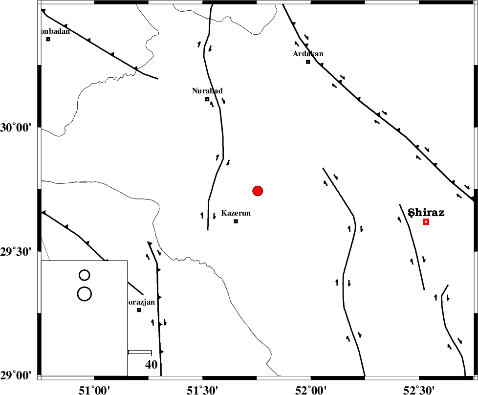
| Location | Lat:29.744 Lon: 51.754 |
| Region | Fars Province, 17 km North-East of Kazerun |
Nearest Cities |
|
| 8 km of Nodan, Fars Province | |
| 14 km East of Seyyed hasan, Fars Province | |
| 17 km North East of Kazerun, Fars Province | |
| 19 km North East of Deris, Fars Province | |
| 21 km North West of Kalani, Fars Province | |
| Depth | 15 km |
| Agency | |
Faults within 150 km: |
|
| KAZERUN_F (Length: 96 km) , Distance to epicenter: 20 km | |
| KAREBASS_F (Length: 98 km) , Distance to epicenter: 31 km | |
| BORAZJAN_F (Length: 168 km) , Distance to epicenter: 54 km | |
| Number of Phases | 7 |
| RMS | 0.1 |
| Number of Stations | 5 |
| Error in Latitude | >3.2 km |
| Error in Longitude | 1.9 km |
| Error in Depth | 9.2 km |
Download waveform in seisan format
to download seisan software Click here
to access information about IIEES stations Click here
Amplitude | ||||||||
| UID | Agency | Station | Component | Amplitude | Period | Arrival Time | Proccessing Time | Signal Clip |
| 137691 | IIEES | AHRM | N | 339.2 | 0.62 | 2018-10-10 17:20:46 | 2018-10-13 08:18:00 | n |
| 137692 | IIEES | GHIR | E | 108.8 | 0.36 | 2018-10-10 17:21:13 | 2018-10-13 08:18:00 | n |
| 137693 | IIEES | GHIR | N | 120.4 | 0.31 | 2018-10-10 17:21:18 | 2018-10-13 08:18:00 | n |
Phase | ||||||||||||
| Agency | Station | Component | Phase Type | Phase Quality | First Motion | Observed Arrival Time | Time Residual | Loc. Flag | Input Weight | Distance | Azimuth | |
| IIEES | AHRM | Z | Pg | E | 2018-10-10 17:20:28 | -0.19 | y | 107 | 205 | |||
| IIEES | AHRM | N | Sg | E | 2018-10-10 17:20:41 | 0.12 | y | 107 | 205 | |||
| IIEES | GHIR | Z | Pg | E | 2018-10-10 17:20:43 | 0.13 | y | 201 | 143 | |||
| IIEES | GHIR | E | Sg | E | 2018-10-10 17:21:07 | -0.06 | y | 201 | 143 | |||
| IIEES | NASN | Z | Pn | E | 2018-10-10 17:21:02 | -0.02 | y | 353 | 16 | |||
| IIEES | YZKH | Z | Pn | E | 2018-10-10 17:21:07 | 0.11 | y | 399 | 42 | |||
| IIEES | KRBR | Z | Pn | E | 2018-10-10 17:21:18 | -0.1 | y | 484 | 86 | |||
کلیه حقوق مادی و معنوی این سایت متعلق به پژوهشگاه بین المللی زلزله شناسی و مهندسی زلزله می باشد.
