خانه / مشخصات زلزله
Magnitude |
:2.7 |
| Date & Time (UTC) | 2018-10-13 00:13:44.8 |
| Date & Time (Local) | 1397/7/21 03:43:44.8 |
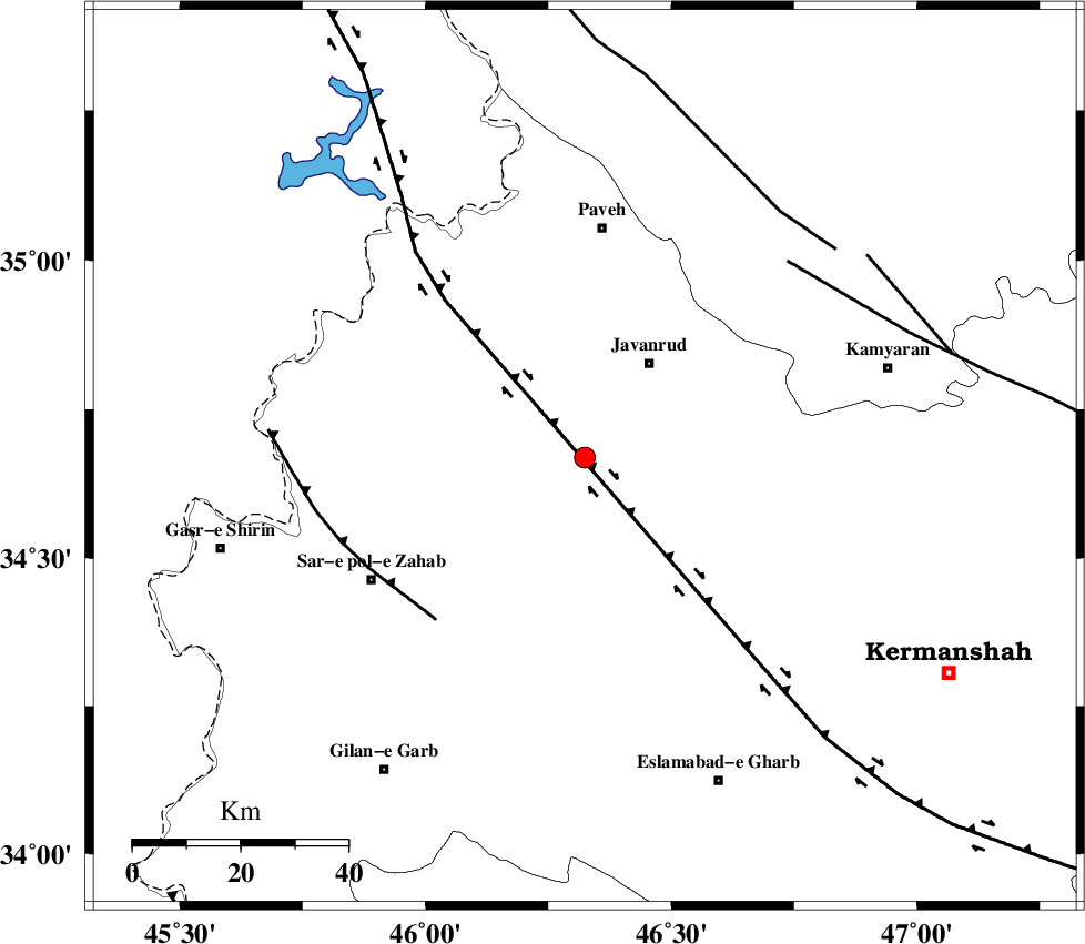
| Location | Lat:34.669 Lon: 46.324 |
| Region | Kermanshah Province, 21 km South-West of Javanrud |
Nearest Cities |
|
| 2 km of Mirabad, Kermanshah Province | |
| 14 km West of Dolatabad, Kermanshah Province | |
| 15 km West of Sarukhan, Kermanshah Province | |
| 16 km East of Qolqoleh, Kermanshah Province | |
| 19 km North of Zavleh olia, Kermanshah Province | |
| Depth | 16 km |
| Agency | |
Faults within 150 km: |
|
| HZF4 (Length: 492 km) , Distance to epicenter: 12 km | |
| MFF8 (Length: 48 km) , Distance to epicenter: 41 km | |
| SARTAKHT_F (Length: 78 km) , Distance to epicenter: 53 km | |
| Number of Phases | 7 |
| RMS | 0.1 |
| Number of Stations | 6 |
| Error in Latitude | >1.4 km |
| Error in Longitude | 1.7 km |
| Error in Depth | 2.6 km |
Download waveform in seisan format
to download seisan software Click here
to access information about IIEES stations Click here
Amplitude | ||||||||
| UID | Agency | Station | Component | Amplitude | Period | Arrival Time | Proccessing Time | Signal Clip |
| 137717 | IIEES | SNGE | N | 171.2 | 0.48 | 2018-10-13 00:14:19 | 2018-10-14 07:14:00 | n |
| 137718 | IIEES | ILBA | N | 183 | 0.42 | 2018-10-13 00:14:25 | 2018-10-14 07:14:00 | n |
| 137719 | IIEES | ILBA | E | 122.3 | 0.42 | 2018-10-13 00:14:26 | 2018-10-14 07:14:00 | n |
| 137720 | IIEES | SRSL | E | 84.9 | 0.43 | 2018-10-13 00:14:47 | 2018-10-14 07:14:00 | n |
| 137721 | IIEES | SRSL | N | 78.1 | 0.34 | 2018-10-13 00:14:48 | 2018-10-14 07:14:00 | n |
Phase | ||||||||||||
| Agency | Station | Component | Phase Type | Phase Quality | First Motion | Observed Arrival Time | Time Residual | Loc. Flag | Input Weight | Distance | Azimuth | |
| IIEES | SNGE | Z | Pg | E | 2018-10-13 00:14:02 | -0.17 | y | 105 | 63 | |||
| IIEES | SNGE | N | Sg | E | 2018-10-13 00:14:15 | 0.1 | y | 105 | 63 | |||
| IIEES | ILBA | Z | Pg | E | 2018-10-13 00:14:04 | 0.03 | y | 116 | 185 | |||
| IIEES | SRSL | Z | Pg | E | 2018-10-13 00:14:16 | 0.03 | y | 189 | 335 | |||
| IIEES | ZNJK | Z | Pn | E | 2018-10-13 00:14:30 | -0.01 | y | 308 | 43 | |||
| IIEES | ASAO | Z | Pn | E | 2018-10-13 00:14:34 | 0.02 | y | 340 | 91 | |||
| IIEES | KHMZ | Z | Pn | E | 2018-10-13 00:14:36 | -0.01 | y | 351 | 106 | |||
کلیه حقوق مادی و معنوی این سایت متعلق به پژوهشگاه بین المللی زلزله شناسی و مهندسی زلزله می باشد.
