خانه / مشخصات زلزله
Magnitude |
:2.5 |
| Date & Time (UTC) | 2018-10-13 21:01:03.0 |
| Date & Time (Local) | 1397/7/22 00:31:03.0 |
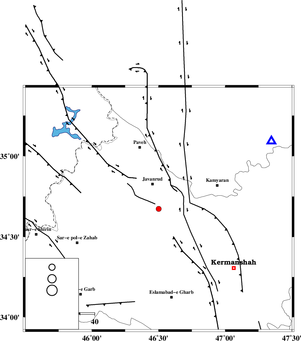
| Location | Lat:34.673 Lon: 46.501 |
| Region | Kermanshah Province, 18 km South of Javanrud |
Nearest Cities |
|
| 3 km of Dolatabad, Kermanshah Province | |
| 11 km of Sarukhan, Kermanshah Province | |
| 14 km West of Borhanaddin, Kermanshah Province | |
| 15 km West of Ravansar, Kermanshah Province | |
| 18 km East of Mirabad, Kermanshah Province | |
| Depth | 14 km |
| Agency | |
Faults within 150 km: |
|
| HZF4 (Length: 492 km) , Distance to epicenter: 13 km | |
| SARTAKHT_F (Length: 78 km) , Distance to epicenter: 42 km | |
| PIRANSHAHR_F (Length: 253 km) , Distance to epicenter: 49 km | |
| Number of Phases | 7 |
| RMS | 0.3 |
| Number of Stations | 5 |
| Error in Latitude | >2 km |
| Error in Longitude | 4.9 km |
| Error in Depth | 9.7 km |
Download waveform in seisan format
to download seisan software Click here
to access information about IIEES stations Click here
Amplitude | ||||||||
| UID | Agency | Station | Component | Amplitude | Period | Arrival Time | Proccessing Time | Signal Clip |
| 137742 | IIEES | ILBA | N | 113.4 | 0.3 | 2018-10-13 21:01:38 | 2018-10-14 07:14:00 | n |
| 137743 | IIEES | ILBA | E | 117.1 | 0.68 | 2018-10-13 21:01:44 | 2018-10-14 07:14:00 | n |
| 137744 | IIEES | SRSL | E | 35 | 0.49 | 2018-10-13 21:02:03 | 2018-10-14 07:14:00 | n |
| 137745 | IIEES | SRSL | N | 41.5 | 0.43 | 2018-10-13 21:02:04 | 2018-10-14 07:14:00 | n |
Phase | ||||||||||||
| Agency | Station | Component | Phase Type | Phase Quality | First Motion | Observed Arrival Time | Time Residual | Loc. Flag | Input Weight | Distance | Azimuth | |
| IIEES | SNGE | Z | Pg | E | 2018-10-13 21:01:18 | -0.52 | y | 90.2 | 59 | |||
| IIEES | ILBA | Z | Pg | E | 2018-10-13 21:01:23 | -0.02 | y | 119 | 193 | |||
| IIEES | ILBA | N | Sg | E | 2018-10-13 21:01:37 | -0.09 | y | 119 | 193 | |||
| IIEES | SRSL | Z | Pg | E | 2018-10-13 21:01:35 | -0.18 | y | 196 | 331 | |||
| IIEES | SRSL | N | Sg | E | 2018-10-13 21:01:59 | 0.19 | y | 196 | 331 | |||
| IIEES | ASAO | Z | Pn | E | 2018-10-13 21:01:51 | 0.59 | y | 324 | 91 | |||
| IIEES | KHMZ | Z | Pn | E | 2018-10-13 21:01:52 | 0.1 | y | 336 | 107 | |||
کلیه حقوق مادی و معنوی این سایت متعلق به پژوهشگاه بین المللی زلزله شناسی و مهندسی زلزله می باشد.
