خانه / مشخصات زلزله
Magnitude |
:2.8 |
| Date & Time (UTC) | 2018-10-20 15:10:31.7 |
| Date & Time (Local) | 1397/7/28 18:40:31.7 |
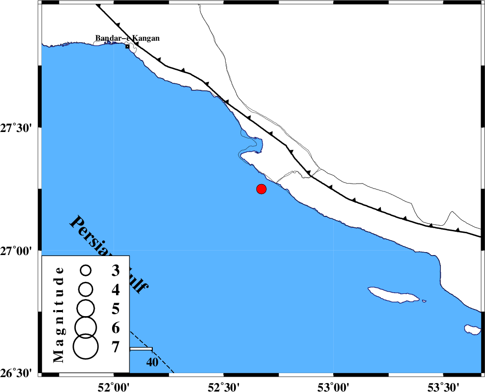
| Location | Lat:27.249 Lon: 52.671 |
| Region | Persian Gulf, 39 km South-West of Mehr |
Nearest Cities |
|
| 17 km South West of Chah-e mobarak, Bushehr Province | |
| 26 km South of Bandar-e asaluyeh, Bushehr Province | |
| 37 km South West of Khoozi, Fars Province | |
| 39 km South West of Mehr, Fars Province | |
| 40 km South West of Ardavan-e olia, Fars Province | |
| Depth | 14 km |
| Agency | |
Faults within 150 km: |
|
| MFF3 (Length: 292 km) , Distance to epicenter: 20 km | |
| ZFF1 (Length: 165 km) , Distance to epicenter: 122 km | |
| LAR_F (Length: 99 km) , Distance to epicenter: 127 km | |
| Number of Phases | 5 |
| RMS | 0.2 |
| Number of Stations | 3 |
| Error in Latitude | >5.9 km |
| Error in Longitude | 2.5 km |
| Error in Depth | 8.6 km |
Download waveform in seisan format
to download seisan software Click here
to access information about IIEES stations Click here
Amplitude | ||||||||
| UID | Agency | Station | Component | Amplitude | Period | Arrival Time | Proccessing Time | Signal Clip |
| 137962 | IIEES | GHIR | N | 272.9 | 0.32 | 2018-10-20 15:11:09 | 2018-10-22 07:04:00 | n |
| 137963 | IIEES | AHRM | N | 37.1 | 0.68 | 2018-10-20 15:11:39 | 2018-10-22 07:04:00 | n |
| 137964 | IIEES | KRBR | E | 6.4 | 0.44 | 2018-10-20 15:12:39 | 2018-10-22 07:04:00 | n |
| 137965 | IIEES | KRBR | N | 6.5 | 0.39 | 2018-10-20 15:12:44 | 2018-10-22 07:04:00 | n |
Phase | ||||||||||||
| Agency | Station | Component | Phase Type | Phase Quality | First Motion | Observed Arrival Time | Time Residual | Loc. Flag | Input Weight | Distance | Azimuth | |
| IIEES | GHIR | Z | Pg | E | 2018-10-20 15:10:51 | -0.16 | y | 119 | 15 | |||
| IIEES | GHIR | N | Sg | E | 2018-10-20 15:11:06 | 0.13 | y | 119 | 15 | |||
| IIEES | AHRM | Z | Pn | E | 2018-10-20 15:11:07 | 0.21 | y | 224 | 323 | |||
| IIEES | AHRM | N | Sg | E | 2018-10-20 15:11:34 | -0.12 | y | 224 | 323 | |||
| IIEES | KRBR | Z | Pn | E | 2018-10-20 15:11:41 | -0.1 | y | 502 | 52 | |||
کلیه حقوق مادی و معنوی این سایت متعلق به پژوهشگاه بین المللی زلزله شناسی و مهندسی زلزله می باشد.
