خانه / مشخصات زلزله
Magnitude |
:2 |
| Date & Time (UTC) | 2018-10-21 16:37:58.8 |
| Date & Time (Local) | 1397/7/29 20:07:58.8 |
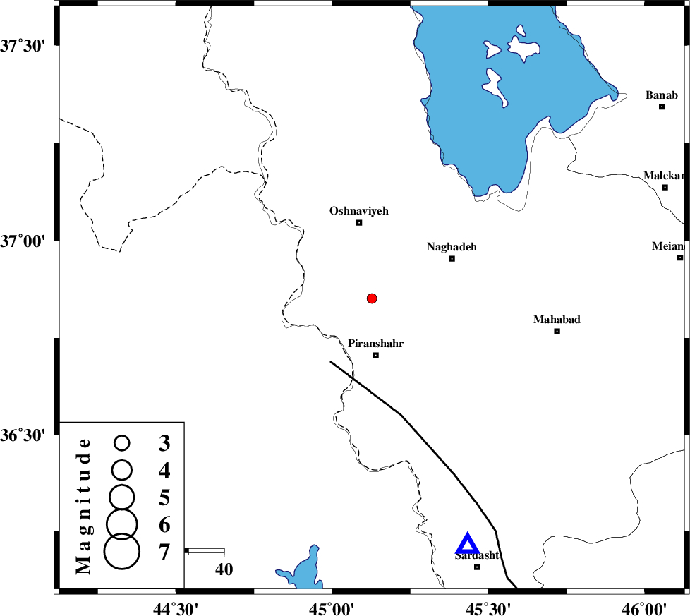
| Location | Lat:36.851 Lon: 45.127 |
| Region | Azarbaijan Gharbi Province, 16 km North of Piranshahr |
Nearest Cities |
|
| 6 km North of Silveh, Azarbaijan Gharbi Province | |
| 11 km North West of Darikeh, Azarbaijan Gharbi Province | |
| 13 km North West of Kardkeshaneh, Azarbaijan Gharbi Province | |
| 15 km South of Nalus, Azarbaijan Gharbi Province | |
| 16 km North of Piranshahr, Azarbaijan Gharbi Province | |
| Depth | 14 km |
| Agency | |
Faults within 150 km: |
|
| PIRANSHAHR_F (Length: 253 km) , Distance to epicenter: 22 km | |
| SALMAS (Length: 20 km) , Distance to epicenter: 136 km | |
| HZF4 (Length: 492 km) , Distance to epicenter: 150 km | |
| Number of Phases | 6 |
| RMS | 0.2 |
| Number of Stations | 3 |
| Error in Latitude | >4.5 km |
| Error in Longitude | 6.8 km |
| Error in Depth | 9.8 km |
Download waveform in seisan format
to download seisan software Click here
to access information about IIEES stations Click here
Amplitude | ||||||||
| UID | Agency | Station | Component | Amplitude | Period | Arrival Time | Proccessing Time | Signal Clip |
| 137978 | IIEES | SRSL | N | 87.8 | 0.41 | 2018-10-21 16:38:26 | 2018-10-22 07:04:00 | n |
| 137979 | IIEES | SRSL | E | 65.2 | 0.42 | 2018-10-21 16:38:26 | 2018-10-22 07:04:00 | n |
| 137980 | IIEES | SNGE | E | 6.5 | 0.62 | 2018-10-21 16:39:23 | 2018-10-22 07:04:00 | n |
| 137981 | IIEES | SNGE | N | 5.9 | 0.55 | 2018-10-21 16:39:28 | 2018-10-22 07:04:00 | n |
Phase | ||||||||||||
| Agency | Station | Component | Phase Type | Phase Quality | First Motion | Observed Arrival Time | Time Residual | Loc. Flag | Input Weight | Distance | Azimuth | |
| IIEES | SRSL | Z | Pg | E | 2018-10-21 16:38:11 | -0.31 | y | 76 | 159 | |||
| IIEES | SRSL | N | Sg | E | 2018-10-21 16:38:21 | -0.01 | y | 76 | 159 | |||
| IIEES | SNGE | Z | Pn | E | 2018-10-21 16:38:41 | 0.4 | y | 280 | 134 | |||
| IIEES | SNGE | N | Sg | E | 2018-10-21 16:39:17 | 0 | y | 280 | 134 | |||
| IIEES | GRMI | Z | Pn | E | 2018-10-21 16:38:47 | 0.09 | y | 326 | 47 | |||
| IIEES | GRMI | N | S | E | 2018-10-21 16:39:22 | -0.17 | y | 326 | 47 | |||
کلیه حقوق مادی و معنوی این سایت متعلق به پژوهشگاه بین المللی زلزله شناسی و مهندسی زلزله می باشد.
