خانه / مشخصات زلزله
Magnitude |
:2.9 |
| Date & Time (UTC) | 2018-10-21 19:38:26.0 |
| Date & Time (Local) | 1397/7/29 23:08:26.0 |
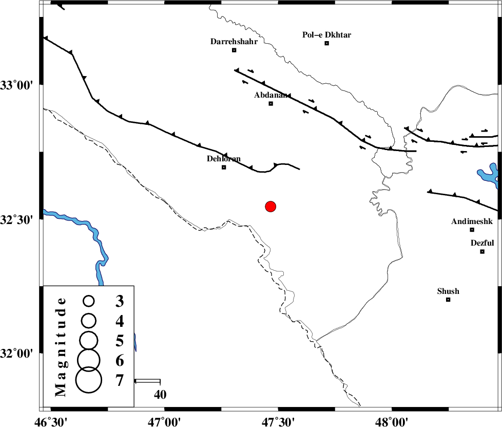
| Location | Lat:32.547 Lon: 47.466 |
| Region | Ilam Province, 25 km South-East of Dehloran |
Nearest Cities |
|
| 10 km North East of Musian, Ilam Province | |
| 25 km South East of Dehloran, Ilam Province | |
| 40 km South West of Sarabbagh, Ilam Province | |
| 43 km South of Abdanan, Ilam Province | |
| 55 km South East of Bishehzar, Ilam Province | |
| Depth | 15 km |
| Agency | |
Faults within 150 km: |
|
| MFF6 (Length: 144 km) , Distance to epicenter: 14 km | |
| BALARUD_F_Z1 (Length: 87 km) , Distance to epicenter: 45 km | |
| BALARUD_F_Z3 (Length: 53 km) , Distance to epicenter: 64 km | |
| Number of Phases | 6 |
| RMS | 0.1 |
| Number of Stations | 6 |
| Error in Latitude | >7.5 km |
| Error in Longitude | 1.4 km |
| Error in Depth | 0 km |
Download waveform in seisan format
to download seisan software Click here
to access information about IIEES stations Click here
Amplitude | ||||||||
| UID | Agency | Station | Component | Amplitude | Period | Arrival Time | Proccessing Time | Signal Clip |
| 137982 | IIEES | SNGE | E | 30.8 | 0.66 | 2018-10-21 19:39:51 | 2018-10-22 07:04:00 | n |
| 137983 | IIEES | ASAO | N | 28 | 0.67 | 2018-10-21 19:40:06 | 2018-10-22 07:04:00 | n |
| 137984 | IIEES | GHVR | N | 17.9 | 0.53 | 2018-10-21 19:40:13 | 2018-10-22 07:04:00 | n |
| 137985 | IIEES | GHVR | E | 19.1 | 0.38 | 2018-10-21 19:40:13 | 2018-10-22 07:04:00 | n |
| 137986 | IIEES | SRSL | N | 14.6 | 0.41 | 2018-10-21 19:40:21 | 2018-10-22 07:04:00 | n |
| 137987 | IIEES | SRSL | E | 8.8 | 0.54 | 2018-10-21 19:40:37 | 2018-10-22 07:04:00 | n |
Phase | ||||||||||||
| Agency | Station | Component | Phase Type | Phase Quality | First Motion | Observed Arrival Time | Time Residual | Loc. Flag | Input Weight | Distance | Azimuth | |
| IIEES | KHMZ | Z | Pn | E | 2018-10-21 19:39:07 | 0.14 | y | 268 | 60 | |||
| IIEES | SNGE | Z | Pn | E | 2018-10-21 19:39:09 | 0.09 | y | 283 | 358 | |||
| IIEES | ASAO | Z | Pn | E | 2018-10-21 19:39:14 | -0.04 | y | 325 | 46 | |||
| IIEES | GHVR | Z | Pn | E | 2018-10-21 19:39:24 | -0.21 | y | 411 | 58 | |||
| IIEES | SRSL | Z | Pn | E | 2018-10-21 19:39:29 | -0.08 | y | 447 | 336 | |||
| IIEES | NASN | Z | Pn | E | 2018-10-21 19:39:36 | 0.04 | y | 502 | 85 | |||
کلیه حقوق مادی و معنوی این سایت متعلق به پژوهشگاه بین المللی زلزله شناسی و مهندسی زلزله می باشد.
