خانه / مشخصات زلزله
Magnitude |
:3.1 |
| Date & Time (UTC) | 2018-10-25 05:49:29.7 |
| Date & Time (Local) | 1397/8/3 09:19:29.7 |
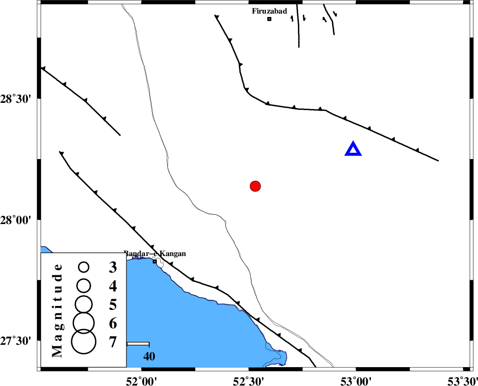
| Location | Lat:28.138 Lon: 52.53 |
| Region | Fars Province, 40 km North-East of Jam |
Nearest Cities |
|
| 23 km East of Dolatabad, Fars Province | |
| 24 km North West of Garmesht, Fars Province | |
| 28 km South West of Hengam, Fars Province | |
| 40 km North East of Jam, Bushehr Province | |
| 45 km South East of Dahrom, Fars Province | |
| Depth | 14 km |
| Agency | |
Faults within 150 km: |
|
| QIR_F (Length: 130 km) , Distance to epicenter: 38 km | |
| MFF3 (Length: 292 km) , Distance to epicenter: 50 km | |
| MFF5 (Length: 74 km) , Distance to epicenter: 66 km | |
| Number of Phases | 5 |
| RMS | 0.2 |
| Number of Stations | 3 |
| Error in Latitude | >9.8 km |
| Error in Longitude | 2 km |
| Error in Depth | 7.3 km |
Download waveform in seisan format
to download seisan software Click here
to access information about IIEES stations Click here
Amplitude | ||||||||
| UID | Agency | Station | Component | Amplitude | Period | Arrival Time | Proccessing Time | Signal Clip |
| 138059 | IIEES | GHIR | N | 2063.1 | 0.44 | 2018-10-25 05:49:51 | 2018-10-27 10:49:00 | n |
| 138060 | IIEES | AHRM | N | 313.2 | 0.6 | 2018-10-25 05:50:18 | 2018-10-27 10:49:00 | n |
Phase | ||||||||||||
| Agency | Station | Component | Phase Type | Phase Quality | First Motion | Observed Arrival Time | Time Residual | Loc. Flag | Input Weight | Distance | Azimuth | |
| IIEES | GHIR | Z | Pg | E | 2018-10-25 05:49:38 | -0.11 | y | 47.8 | 70 | |||
| IIEES | GHIR | N | Sg | E | 2018-10-25 05:49:44 | -0.06 | y | 47.8 | 70 | |||
| IIEES | AHRM | Z | Pg | E | 2018-10-25 05:49:53 | -0.17 | y | 145 | 304 | |||
| IIEES | AHRM | N | Sg | E | 2018-10-25 05:50:11 | 0.09 | y | 145 | 304 | |||
| IIEES | KRBR | Z | Pn | E | 2018-10-25 05:50:35 | 0.35 | y | 460 | 63 | |||
کلیه حقوق مادی و معنوی این سایت متعلق به پژوهشگاه بین المللی زلزله شناسی و مهندسی زلزله می باشد.
