خانه / مشخصات زلزله
Magnitude |
:4.3 |
| Date & Time (UTC) | 2018-11-05 20:32:08.7 |
| Date & Time (Local) | 1397/8/15 00:02:08.7 |
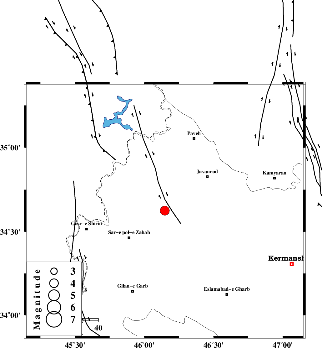
| Location | Lat:34.625 Lon: 46.148 |
| Region | Kermanshah Province, 30 km North-East of Sar-e pol-e zahab |
Nearest Cities |
|
| 11 km of Qolqoleh, Kermanshah Province | |
| 16 km West of Mirabad, Kermanshah Province | |
| 21 km North West of Zavleh olia, Kermanshah Province | |
| 21 km East of Bazmirabad, Kermanshah Province | |
| 22 km North East of Rijab, Kermanshah Province | |
| Depth | 14 km |
| Agency | |
Faults within 150 km: |
|
| HZF4 (Length: 492 km) , Distance to epicenter: 16 km | |
| MFF8 (Length: 48 km) , Distance to epicenter: 28 km | |
| SARTAKHT_F (Length: 78 km) , Distance to epicenter: 68 km | |
| Number of Phases | 9 |
| RMS | 0.2 |
| Number of Stations | 8 |
| Error in Latitude | >1.7 km |
| Error in Longitude | 2.8 km |
| Error in Depth | 4.6 km |
Download waveform in seisan format
to download seisan software Click here
to access information about IIEES stations Click here
Amplitude | ||||||||
| UID | Agency | Station | Component | Amplitude | Period | Arrival Time | Proccessing Time | Signal Clip |
| 138281 | IIEES | SNGE | E | 6338.9 | 0.52 | 2018-11-05 20:32:44 | 2018-11-06 10:07:00 | n |
| 138282 | IIEES | SNGE | N | 8408.8 | 0.4 | 2018-11-05 20:32:44 | 2018-11-06 10:07:00 | n |
| 138283 | IIEES | GIDE | N | 343.2 | 0.68 | 2018-11-05 20:34:15 | 2018-11-06 10:07:00 | n |
| 138284 | IIEES | GIDE | E | 469 | 0.68 | 2018-11-05 20:34:22 | 2018-11-06 10:07:00 | n |
Phase | ||||||||||||
| Agency | Station | Component | Phase Type | Phase Quality | First Motion | Observed Arrival Time | Time Residual | Loc. Flag | Input Weight | Distance | Azimuth | |
| IIEES | ILBA | Z | Pg | E | 2018-11-05 20:32:27 | -0.05 | y | 111 | 177 | |||
| IIEES | ILBA | E | Sg | E | 2018-11-05 20:32:41 | 0.06 | y | 111 | 177 | |||
| IIEES | SRSL | Z | Pg | E | 2018-11-05 20:32:39 | -0.17 | y | 188 | 340 | |||
| IIEES | ZNJK | Z | Pn | E | 2018-11-05 20:32:57 | 0.33 | y | 323 | 45 | |||
| IIEES | ASAO | Z | Pn | E | 2018-11-05 20:33:01 | 0.33 | y | 356 | 90 | |||
| IIEES | ASAO | E | Sg | E | 2018-11-05 20:33:48 | -0.16 | y | 356 | 90 | |||
| IIEES | KHMZ | Z | Pn | E | 2018-11-05 20:33:01 | -0.33 | y | 365 | 105 | |||
| IIEES | GIDE | Z | Pn | E | 2018-11-05 20:33:09 | 0.01 | y | 425 | 52 | |||
| IIEES | CHTH | Z | Pn | E | 2018-11-05 20:33:15 | -0.01 | y | 475 | 71 | |||
کلیه حقوق مادی و معنوی این سایت متعلق به پژوهشگاه بین المللی زلزله شناسی و مهندسی زلزله می باشد.
