خانه / مشخصات زلزله
Magnitude |
:2.7 |
| Date & Time (UTC) | 2018-11-27 12:19:11.7 |
| Date & Time (Local) | 1397/9/6 15:49:11.7 |
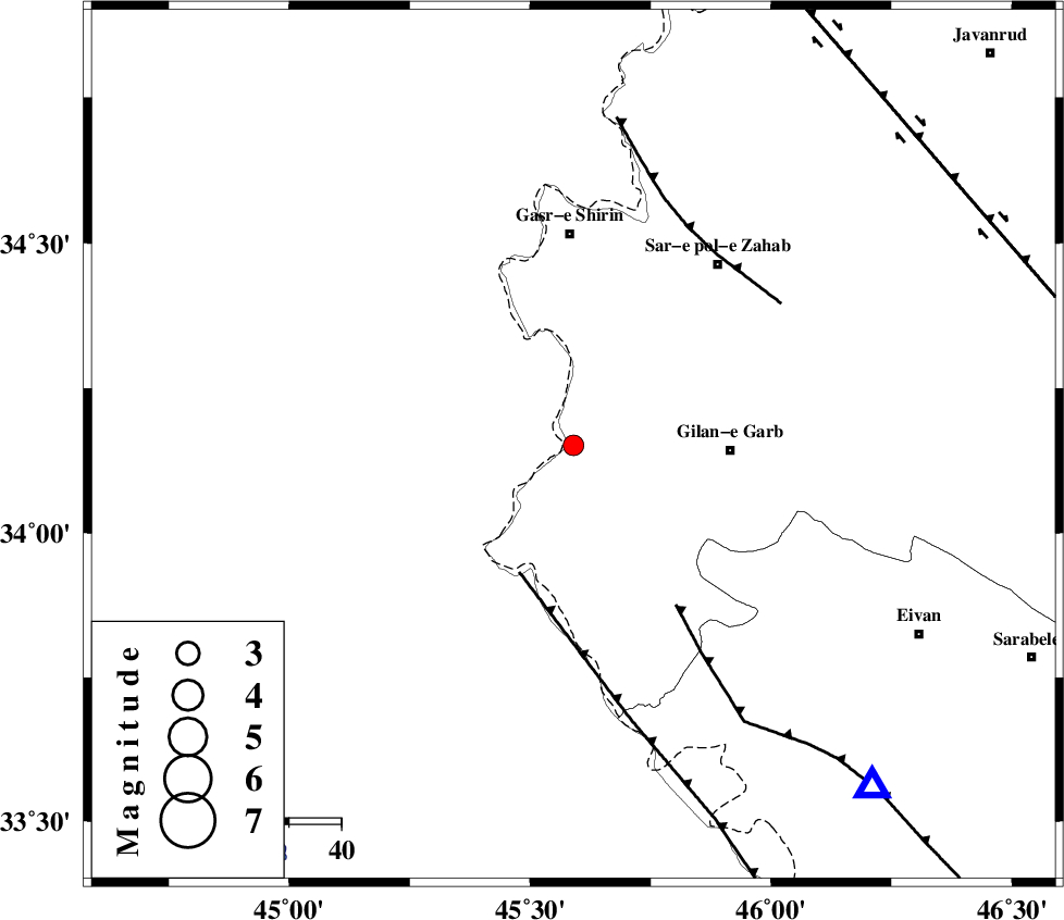
| Location | Lat:34.151 Lon: 45.59 |
| Region | Kermanshah Province, 30 km -West of Gilan-E-Gharb |
Nearest Cities |
|
| 30 km South East of Khosravi, Kermanshah Province | |
| 30 km North West of Gilan-E-Gharb, Kermanshah Province | |
| 31 km North of Sumar, Kermanshah Province | |
| 31 km South West of Chub baghan, Kermanshah Province | |
| 33 km South of Seyyed sohrab, Kermanshah Province | |
| Depth | 14 km |
| Agency | |
Faults within 150 km: |
|
| ZFF4 (Length: 128 km) , Distance to epicenter: 26 km | |
| MFF7 (Length: 99 km) , Distance to epicenter: 36 km | |
| MFF8 (Length: 48 km) , Distance to epicenter: 46 km | |
| Number of Phases | 5 |
| RMS | 0.1 |
| Number of Stations | 3 |
| Error in Latitude | >1.4 km |
| Error in Longitude | 2.8 km |
| Error in Depth | 5.1 km |
Download waveform in seisan format
to download seisan software Click here
to access information about IIEES stations Click here
Amplitude | ||||||||
| UID | Agency | Station | Component | Amplitude | Period | Arrival Time | Proccessing Time | Signal Clip |
| 138778 | IIEES | SNGE | E | 53.4 | 0.53 | 2018-11-27 12:20:12 | 2018-11-28 11:07:00 | n |
| 138779 | IIEES | SRSL | N | 66.9 | 0.67 | 2018-11-27 12:20:18 | 2018-11-28 11:07:00 | n |
| 138780 | IIEES | SRSL | E | 40.7 | 0.53 | 2018-11-27 12:20:19 | 2018-11-28 11:07:00 | n |
Phase | ||||||||||||
| Agency | Station | Component | Phase Type | Phase Quality | First Motion | Observed Arrival Time | Time Residual | Loc. Flag | Input Weight | Distance | Azimuth | |
| IIEES | ILBA | Z | Pg | E | 2018-11-27 12:19:25 | 0 | y | 81.7 | 135 | |||
| IIEES | SNGE | Z | Pg | E | 2018-11-27 12:19:43 | -0.13 | y | 192 | 57 | |||
| IIEES | SNGE | N | Sg | E | 2018-11-27 12:20:06 | 0.08 | y | 192 | 57 | |||
| IIEES | SRSL | Z | Pn | E | 2018-11-27 12:19:48 | 0.11 | y | 229 | 356 | |||
| IIEES | SRSL | N | Sg | E | 2018-11-27 12:20:16 | -0.05 | y | 229 | 356 | |||
کلیه حقوق مادی و معنوی این سایت متعلق به پژوهشگاه بین المللی زلزله شناسی و مهندسی زلزله می باشد.
