خانه / مشخصات زلزله
Magnitude |
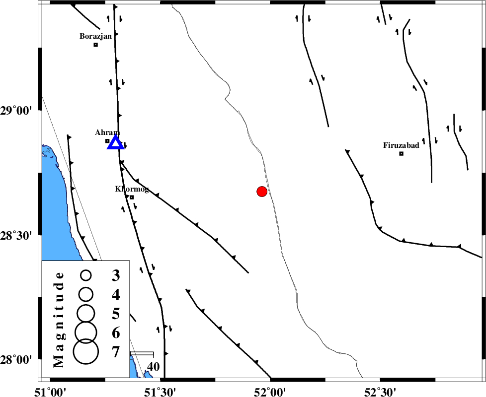
:2.9 |
| Date & Time (UTC) | 2018-12-01 16:38:13.0 |
| Date & Time (Local) | 1397/9/10 20:08:13.0 |
| Location | Lat:28.674 Lon: 51.962 |
| Region | Bushehr Province, 25 km South-West of Farashband |
Nearest Cities |
|
| 25 km South West of Farashband, Fars Province | |
| 29 km South of Aviz, Fars Province | |
| 37 km North East of Shanbeh, Bushehr Province | |
| 39 km North West of Dahrom, Fars Province | |
| 48 km South of Nujin, Fars Province | |
| Depth | 5 km |
| Agency | |
Faults within 150 km: |
|
| MFF5 (Length: 74 km) , Distance to epicenter: 30 km | |
| KAREBASS_F (Length: 98 km) , Distance to epicenter: 41 km | |
| QIR_F (Length: 130 km) , Distance to epicenter: 41 km | |
| Number of Phases | 6 |
| RMS | 0 |
| Number of Stations | 4 |
| Error in Latitude | >3.4 km |
| Error in Longitude | 1.2 km |
| Error in Depth | 3.2 km |
Download waveform in seisan format
to download seisan software Click here
to access information about IIEES stations Click here
Amplitude | ||||||||
| UID | Agency | Station | Component | Amplitude | Period | Arrival Time | Proccessing Time | Signal Clip |
| 138880 | IIEES | AHRM | N | 696.4 | 0.41 | 2018-12-01 16:38:41 | 2018-12-02 10:01:00 | n |
| 138881 | IIEES | AHRM | E | 671.5 | 0.41 | 2018-12-01 16:38:44 | 2018-12-02 10:01:00 | n |
Phase | ||||||||||||
| Agency | Station | Component | Phase Type | Phase Quality | First Motion | Observed Arrival Time | Time Residual | Loc. Flag | Input Weight | Distance | Azimuth | |
| IIEES | AHRM | Z | Pg | E | 2018-12-01 16:38:25 | 0 | y | 68.3 | 288 | |||
| IIEES | AHRM | N | S | E | 2018-12-01 16:38:34 | 0 | y | 68.3 | 288 | |||
| IIEES | GHIR | Z | Pg | E | 2018-12-01 16:38:33 | 0.01 | y | 109 | 113 | |||
| IIEES | GHIR | Z | Sg | E | 2018-12-01 16:38:48 | -0.01 | y | 109 | 113 | |||
| IIEES | NASN | Z | Pn | E | 2018-12-01 16:39:19 | -0.02 | y | 465 | 10 | |||
| IIEES | YZKH | Z | Pn | E | 2018-12-01 16:39:22 | 0.02 | y | 483 | 31 | |||
کلیه حقوق مادی و معنوی این سایت متعلق به پژوهشگاه بین المللی زلزله شناسی و مهندسی زلزله می باشد.
